
The Brahmaputra is a trans-boundary river which flows through Tibet (China), Northeastern India, and Bangladesh. It is known as Brahmaputra or Luit in Assamese,Yarlung Tsangpo in Tibetan, the Siang/Dihang River in Arunachali and Jamuna River in Bengali. It is the 9th largest river in the world by discharge, and the 15th longest.

Lakhimpur district is an administrative district in the state of Assam in India. The district headquarter is located at North Lakhimpur. The district is bounded on the North by Siang and Papumpare districts of Arunachal Pradesh and on the East by Dhemaji District and Subansiri River. Majuli District stands on the Southern side and Biswanath District is on the West.

Morigaon district is an administrative district in the state of Assam in India. The district headquarters is located at Morigaon. The ancient place of occult Mayong is located in this district as well as Pobitora Wildlife Sanctuary.
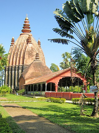
Sivasagar district, formerly known as Sibsagar, is one of the 34 districts of Assam state in Northeast India. Sivasagar city is the administrative headquarters of this district. This historic place is also known for its rich biodiversity. The districts covers an area of 2668 square kilometers. The district comprises two sub-divisions – Sivasagar and Nazira. The district of Sivasagar lies between 26.45°N and 27.15°N latitudes and 94.25°E and 95.25°E longitudes. The district is bounded by the Brahmaputra River to the north, Nagaland to the south, the Charaideo district to the east and the Jhanji River to the west. The Sivasagar district has acquired its distinct identity due to the co-existence of different races, tribes, languages and cultures.
This article discusses the geological origin, geomorphic characteristics, and climate of the northeastern Indian state of Assam. Extending from 89° 42′ E to 96° E longitude and 24° 8′ N to 28° 2′ N latitude, it has an area of 78,438 km2, similar to that of Ireland or Austria.

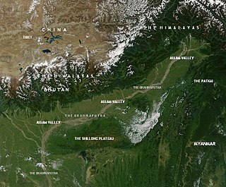
Assam is the main and oldest state in the North-East Region of India and as the gateway to the rest of the Seven Sister States. The land of red river and blue hills, Assam comprises three main geographical areas: the Brahmaputra Valley which stretching along the length of the Brahmaputra river, the Barak Valley extending like a tail, and the intervening Karbi Plateau and North Cachar Hills. Assam shares its border with Meghalaya, Arunachal Pradesh, Nagaland, Manipur, Tripura, Mizoram and West Bengal; and there are National Highways leading to their capital cities. It also shares international borders with Bhutan and Bangladesh and is very close to Myanmar. In ancient times Assam was known as Pragjyotisha or Pragjyotishpura, and Kamarupa.

Upper Assam is an administrative division of the state of Assam comprising the undivided Lakhimpur and Sivasagar districts, of the upper reaches of the Brahmaputra valley. The other divisions are: Lower Assam, North Assam and Hills and Barak Valley. The division is under the jurisdiction of a Commissioner, stationed at Jorhat.
The Mitong is a river of Sivasagar District, Assam, India. It is a tributary of the Jhanji River.
Pani-Dihing Bird Sanctuary is a 33.93-square-kilometre (13.10 sq mi) bird sanctuary located in Sivasagar district, Assam. It is 22 km (14 mi) away from Sivasagar town. This protected area was established as a Bird Sanctuary in August 1996 by the Government of Assam. It was identified as a potential bird sanctuary in late 1980s. The first systematic ornithological surveys in the area was conducted by noted conservationist Dr Anwaruddin Choudhury in 1987-88. Pani-Dihing is a complex of grassland and wetland. Some of the wetlands including channels or beels include Tokia, Jarjaria, Boloma, Dighali, Singorajan, Sagunpora, Kandhulijan, Fulai and Gaiguma. A detailed background of Pani-Dihing has also been published. Pani-Dihing and adjacent areas is on the global map being an Important Bird & Biodiversity Area
Chandra Prasad Saikia (1927–2006) was a writer from Assam, India. He was the president of the Asam Sahitya Sabha held at Hajo and Jorhat district, Assam in 1999 and 2000, respectively. Saikia was born on 8 July 1927 in Jalukgaon, Jhanji in Sivasagar district, Assam. After having primary education in Sivasagar he had left for Kolkata for higher education.
Jhanji is a small semi-rural area situated in Sivasagar and Jorhat districts. The river Jhanji River divides these two districts.
Jhanji Hemnath Sarma College is a college situated at Jhanji, Sivasagar, Assam, India. It was founded on 25 July 1964. The college is affiliated to Dibrugarh University and recognized by University Grants Commission.
Assam – 16th largest, 15th most populous and 26th most literate state of the 28 states of the democratic Republic of India. Assam is at 14th position in life expectancy and 8th in female-to-male sex ratio. Assam is the 21st most media exposed states in India. The Economy of Assam is largely agriculture based with 69% of the population engaged in it. Growth rate of Assam's income has not kept pace with that of India's during the Post-British Era; differences increased rapidly since the 1970s. While the Indian economy grew at 6 percent per annum over the period of 1981 to 2000, the same of Assam's grew only by 3.3 percent.
Bhogamukh is located in Assam, India. It comes under two districts Jorhat and Sivasagar.
The Brahmaputra floods refers to a catastrophic flood event that occurred in 2012 along the Brahmaputra River and its tributaries, as well as in subsequent years.
Charul Kora is a small scattered rural village in the Sivasagar tehsil, Sivasagar district, Assam state, India. In the census and other sources it is qualified as No.2 in order to distinguish it from the nearly homonymous village of Chaul Kora (No.1) in the same district, about 8 km to the southwest.
Khar-Khori or Khar Khori is a tiny village in the Sivasagar tehsil, Sivasagar district, Assam state, India. It is located about 330 km east by northeast of Dispur, 20 km west of Sivasagar, and 5 km southeast of the Brahmaputra river. Its PIN is 785640.

The Dikhow River is a left tributary of the Brahmaputra River in the Indian state of Assam. It rises in the Zunheboto district in Nagaland, flows through the Sivasagar district of Assam and joins the Brahmaputra at Dikhowmukh.
The Gabharu River is a northern bank tributary of the Brahmaputra River in the Indian state of Assam. The Gabharu river originates in the Kalafangapo hills of Arunachal Pradesh in the West Kameng District and flows through Sonitpur district of Assam before its confluence with the Brahmaputra river at Gadharu Mukh of Sonitpur district. The Gabharu river consists of two right bank subtributaries known as Sonairupai river and Gelgeli river and Mora Depota river is the left bank sub tributary.

