South Jhitakaiya दक्षिण झिटकैया | |
|---|---|
Village Development Committee | |
 | |
| Country | |
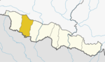
| Zone | Narayani Zone |
| District | Bara District |
| Population (1991) | |
• Total | 7,235 |
| Time zone | UTC+5:45 (Nepal Time) |
South Jhitakaiya is a town and Village Development Committee, near by Dewapur- Chowk/Pokhara/Mandir/School/Police Station and Pashah River, Bara District in the Madhesh Province of south-eastern Nepal. At the time of the 1991 Nepal census it had a population of 7,235. [1]