
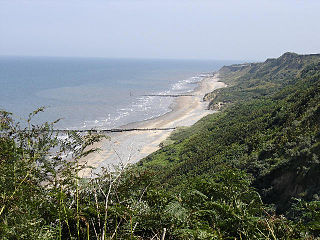
Durlston Country Park is a 320-acre country park and nature reserve stretching along the coast of the Isle of Purbeck on the outskirts of Swanage in Dorset, England. The park is a popular destination for tourists to enjoy the walks, views, visitor centre, climbing, and wildlife, including Durlston Castle, the Great Globe, Tilly Whim Caves, and Anvil Point Lighthouse. It is a gateway to the Jurassic Coast World Heritage Site, forms part of the 630 mile South West Coast Path, and is owned by Dorset Council.

The River Dove is the principal river of the southwestern Peak District, in the Midlands of England and is around 45 miles (72 km) in length. It rises on Axe Edge Moor near Buxton and flows generally south to its confluence with the River Trent at Newton Solney. From there, its waters reach the North Sea via the Humber Estuary. For almost its entire course it forms the boundary between the counties of Staffordshire and Derbyshire. The river meanders past Longnor and Hartington and cuts through a set of deep limestone gorges, Beresford Dale, Wolfscote Dale, Milldale and Dovedale.

The Swale is a tidal channel of the Thames estuary that separates the Isle of Sheppey from the rest of Kent. On its banks is a 6,509.4-hectare (16,085-acre) biological Site of Special Scientific Interest which stretches from Sittingbourne to Whitstable in Kent. It is also a Ramsar internationally important wetland site and a Special Protection Area under the European Union Directive on the Conservation of Wild Birds. Parts of it are a Nature Conservation Review site, Grade I, National Nature Reserves, a Kent Wildlife Trust nature reserve and a Local Nature Reserve.
The Lynn River is a fresh water river located in Norfolk County in Southwestern Ontario, Canada. It empties into Lake Erie at Port Dover.

Rolleston on Dove, also known simply as Rolleston, is a village and civil parish in the East Staffordshire district, in the county of Staffordshire, England near Burton upon Trent. On 28 March 1983 the parish was renamed from "Rolleston" to "Rolleston on Dove". According to the University of Nottingham English Place-names project, the settlement name Rolleston could mean 'Hrothwulf's farm/settlement' or 'Hrolfr's farm/settlement'. The 2011 census for Rolleston returned 1,467 households and 3,267 residents.

Nailstone is a village and civil parish in the Hinckley and Bosworth district of Leicestershire, England, situated to the west of Leicester and 3 miles (5 km) north-east of Market Bosworth. According to the 2001 census the parish had a population of 521, reducing slightly to 514 at the 2011 census. The village has a primary school: Dove Bank Primary School the catchment area for which also includes the neighbouring village of Bagworth. The village also has a pub: The Bull's Head

Breckland in Norfolk and Suffolk is a 39,433 hectare Special Protection Area (SPA) under the European Union Directive on the Conservation of Wild Birds. The SPA partly overlaps the 7,544 hectare Breckland Special Area of Conservation. As a landscape region it is an unusual natural habitat of England. It comprises the gorse-covered sandy heath that lies mostly in the south of the county of Norfolk but also in the north of Suffolk. An area of considerable interest for its unusual flora and fauna, it lies to the east of another unusual habitat, the Fens, and to the south west of the Broads. The typical tree of this area is the Scots pine. Breckland is one of the driest areas in England.

Rolleston station is around half a mile from the small village of Rolleston, one of the Trent-side villages near Southwell in Nottinghamshire, England. The station adjoins Southwell Racecourse.
Shree Jalaram Prarthana Mandal is a Hindu mandir dedicated to Jalaram Bapa who was an Indian saint on Narborough Road in the West End of Leicester, England. According to the official website, the foundation stone was laid on a Monday.
The Norfolk Coast Area of Outstanding Natural Beauty is a protected landscape in Norfolk, England. It covers over 450 km2 of coastal and agricultural land from The Wash in the west through coastal marshes and cliffs to the sand dunes at Winterton in the east. It was designated AONB in 1968, under the National Parks and Access to the Countryside Act 1949.

Thompson Water, Carr and Common is a 154.7-hectare (382-acre) biological Site of Special Scientific Interest north of Thetford in Norfolk. Most of it is managed by the Norfolk Wildlife Trust as Thompson Common. It is a Nature Conservation Review site, Grade I, and part of the Norfolk Valley Fens Special Area of Conservation. It is crossed by the Great Eastern Pingo Trail Local Nature Reserve.

The Colne Valley Regional Park is 43 square miles (110 km2) of parks, green spaces and reservoirs alongside the often multi-channel River Colne and parallel Grand Union Canal, mainly in Hertfordshire and Buckinghamshire, with parts in the London Borough of Hillingdon, Berkshire and a small area in Surrey.

Alde–Ore Estuary is a 2,534 hectare biological and geological Site of Special Scientific Interest which stretches along the Suffolk coast between Aldeburgh and Bawdsey, and also includes parts of the Alde, Ore and Butley Rivers. It is in the Suffolk Coast and Heaths Area of Outstanding Natural Beauty, and is a Grade I Nature Conservation Review site, a Special Area of Conservation, a Ramsar internationally important wetland site, and a Special Protection Area under the European Union Directive on the Conservation of Wild Birds. It includes two Geological Conservation Review sites, "Orfordness and Shingle Street" and "The Cliff, Gedgrave", and two nature reserves managed by the Suffolk Wildlife Trust, Alde Mudflats and Simpson's Saltings. The coastal part of the site is Orfordness-Havergate, a National Nature Reserve, and Orford Ness is managed by the National Trust, while Havergate Island is managed by the Royal Society for the Protection of Birds.
Alde Mudflats is a 22 hectare nature reserve west of Iken in Suffolk. It is owned by the Crown Estate and managed by the Suffolk Wildlife Trust. It is in the Suffolk Coast and Heaths Area of Outstanding Natural Beauty, and part of the Alde-Ore Estuary Site of Special Scientific Interest, Ramsar internationally important wetland site, Special Area of Conservation, Special Protection Area under the European Union Directive on the Conservation of Wild Birds, and Grade I Nature Conservation Review site,
Tutbury Jinnie was the name given to a local rail service between the stations at Burton upon Trent and Tutbury. The service consisted, at various times, of up to eight trains on weekdays and two on Sundays.

Rolleston Hall was a country house in Rolleston-on-Dove, Staffordshire. Originally built in the early 17th century for Sir Edward Mosley, it had been substantially renovated after a fire in 1871. It was the seat of the Mosley family until the house was demolished in 1928.

Southwell railway station was a railway station that served the minster town of Southwell in Nottinghamshire, England from 1847 to 1959.

Fishguard and Goodwick is the name of a community that wraps around Fishguard Bay, on the northern coast of Pembrokeshire, Wales. It comprises the two towns of Fishguard and Goodwick, with their neighbourhoods of Dyffryn, Harbour Village, Penyraber, Lower Town, and Stop-and-Call. Within the community are two railway stations and Goodwick Ferry Terminal, which is the terminus of the A40 London to Fishguard Trunk Road.

Portholme is a 106-hectare (260-acre) biological Site of Special Scientific Interest in the Parish of Brampton between Huntingdon and Godmanchester in Cambridgeshire, England. It is a Nature Conservation Review site, and a Special Area of Conservation.
Cranberry Rough is an 81.1-hectare (200-acre) biological and geological Site of Special Scientific Interest in the parish of Hockham, east of Attleborough in Norfolk. It is a Nature Conservation Review site, Grade 2, and the Great Eastern Pingo Trail, which is a Local Nature Reserve, goes through the site. Part of it is a Geological Conservation Review site, and it is part of the Breckland Special Protection Area.
