
Luís Severino de Almeida Cabral was the first President of Guinea-Bissau. He served from 1974 to 1980, when a military coup d'état led by João Bernardo Vieira deposed him. Luís Cabral was a half-brother of Amílcar Cabral, with whom he co-founded the African Party for the Independence of Guinea and Cape Verde (PAIGC) in 1956.
Articles related to Guinea-Bissau include:

Bubaque is one of the Bijagós Islands in Guinea-Bissau, and is also the name of its main town. The island has a population of 6,427, the town Bubaque 4,299. The area of the island is 75 km², it is 13.6 km long and 8 km wide.
Manuel Saturnino da Costa is a Guinea-Bissau politician who served as Prime Minister of Guinea-Bissau from 26 October 1994 to 6 June 1997.
Formosa is an island in the Bissagos Islands, Guinea-Bissau, part of the sector of Caravela. Its area is 140 km², its length is 19.9 km and its width is 10 km. It forms practically one island with Ponta and Maio, separated by creeks. The island has a population of 1,873 ; the largest village is Abú.

Roxa or Canhabaque is an island in the Bissagos Islands, Guinea-Bissau. It is part of the sector of Bubaque. Its area is 111 square kilometres (43 sq mi); it is 20 kilometres (12 mi) long and 11 kilometres (6.8 mi) wide. The island has a population of 2,478, divided over the villages Ambuduco, Ampucute, Ancanhozinho, Indenazinho, Ancaguine, Ancatipe, Angaura, Indena Grande, Ga-Cote, Inore, Ambena, Bine, Inhoda, Idjoue, Eboco, Meneque, Ancanam, Anghudjiga, Anghumba and Antchurupe. There is a lighthouse on the east side of the island, its focal height is 26 m (85 ft).
Uno is an island in the Bissagos Islands, Guinea-Bissau. With the islands Eguba, Orango, Unhocomo, Unhocomozinho and Uracane it forms the sector of Uno. Its area is 104 km2 (40 sq mi). The island has a population of 3,324, the sector of Uno 6,751. It is part of the Boloma Bijagós Biosphere Reserve.
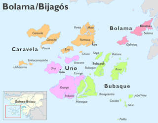
Orangozinho is an island in the Bissagos Islands, Guinea-Bissau, it is part of the Bolama Region and the Bubaque sector. Its area is 107 km², its length is 19 km and its width is 11.8 km. It has a population of 706 ; the largest village is Wite. The island forms a part of the Orango National Park.
Carache is an island in the northwestern part of the Bissagos Islands group, Guinea-Bissau. It belongs to the Bolama Region and the sector of Caravela. Its area is 80.4 km², the island is 18.7 km long and 7.3 km wide. It is separated from the island of Caravela by a narrow channel. The largest villages on the island are Binte and Ampintcha. Its population is 428.
Uracane is an island in the Bissagos Islands of Guinea-Bissau. The island has a population of 1,181. It is part of the sector of Uno within the Bolama Region. It lies northeast of Uno, and south of Formosa.
Caió is a sector in the Cacheu Region of Guinea-Bissau. Its population is 12,696. The island Pecixe is part of the sector.
Raúl Pires Ferreira Chaves was a Portuguese civil engineer and inventor. A graduate of the Instituto Superior Técnico of Lisbon, he lived and primarily worked in Portugal, Portuguese Cape Verde and Portuguese Guinea.

The Orango National Park is a protected area in Guinea-Bissau. It was established in December 2000. The park has an area of 1,582 km2 (611 sq mi), which is partly marine. It covers the southern part of the Bissagos Archipelago, notably the islands Orango, Orangozinho, Meneque, Canogo and Imbone, and the surrounding sea. The marine area does not exceed 30 m (100 ft) depth. The park is administered by: Instituto da Biodiversidade e das Áreas Protegidas da Guiné-Bissau. About 160 km2 (60 sq mi) of the park is covered by mangroves. It plays a crucial role for the reproduction of molluscs, fish and sea turtles.
Jorge Ferreira Chaves was a Portuguese architect.
The Liberation Front of Portuguese Guinea and Cape Verde was a militant political party in Guinea-Bissau, then part of Portuguese Guinea, formed to seek independence from Portugal.
Rubane is one of the Bijagós Islands in Guinea-Bissau. The island has a population of 165. The island lies northeast of the larger island of Bubaque, across a narrow strait. It is part of the Boloma Bijagós Biosphere Reserve.

