
Bubaque is one of the Bijagós Islands in Guinea-Bissau, and is also the name of its main town. The island has a population of 6,427, the town Bubaque 4,299. The area of the island is 75 km², it is 13.6 km long and 8 km wide.

Bolama is the closest of the Bijagós Islands to the mainland of Guinea-Bissau, and is also the name of the island's main town, the capital of the Bolama Region. The island has a population of 6,024, the town Bolama 4,819.
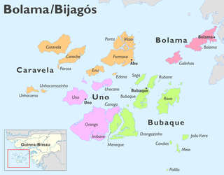
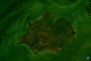
Orango is one of the Bijagós Islands, located 60 kilometers off the coast of mainland Guinea-Bissau. At 272.5 km2 (105.2 sq mi), it is the largest island in the archipelago. The island has a population of 1,250 ; the largest village is Eticoga. With the neighbouring islands Imbone, Canongo, Meneque and Orangozinho it forms the Orango National Park. It belongs to the Uno Sector.
João Vieira is an island in the Bijagós Archipelago of Guinea-Bissau. Its population is 6. It is part of the João Vieira and Poilão Marine National Park. It lies 11 nmi (20 km) north-northeast of the island Poilão. Other nearby islands are Meio and Cavalos. The islands are important nesting grounds for sea turtles.
Galinhas is an island in the Bijagós Archipelago of Guinea-Bissau. Galinhas is located about 25 km southwest of Bolama town. The Canal de Bolama separates it from Bolama Island, the easternmost island of the group that lies close to the mainland. The area of the island is 50 km², its length is 10 km and its width is 6 km.
Farim is a town of northern Guinea-Bissau. It sits on the north bank of the Farim/Cacheu River, about 215 km up the river from Cacheu. Population 8,661.

Ilhéu das Rolas is an islet in the African island nation of São Tomé and Príncipe. The island lies on the equator, off the southern tip of São Tomé Island, separated by Canal das Rolas. Its maximum elevation is 96 m. Its population is 76. It is part of the Caué District. Access is only by ferry departing from Ponta Baleia on São Tomé Island. There is a lighthouse on the islet, built in 1929. Its focal height is 106 meters and its range is 12 nmi. The island is home to a small resort, the Pestana Equador.

Ilhéu das Cabras is an uninhabited island in the Gulf of Guinea. It is one of the smaller islands of São Tomé and Príncipe. The islet is located about 2 km off the northeast coast of the island of São Tomé, 8 km north of the city centre of São Tomé. The islet consists of two hills, about 90 metres high. There is a lighthouse on the northeastern summit, built in 1890; its focal height 97 metres and its range is 12 nmi. The islet was mentioned as "Mooro Caebres" in the 1665 map by Johannes Vingboons.

Seal Island is an island on the outermost extreme of Southwestern Nova Scotia, Canada, in the Municipality of the District of Argyle in Yarmouth County. It is approximately 4.3 kilometres (2.7 mi) long and 0.8 kilometres (0.50 mi) wide and is surrounded on its east, south and west sides by dangerous shoals. It is surrounded by the Atlantic Ocean and is the biggest of a group of five islands which extend north for 12 kilometres (7.5 mi). It is the second southernmost point of land of Nova Scotia. The southern tip of nearby Cape Sable Island is 250 metres (820 ft) farther south than the southern tip of land on Seal Island.

Caravela is the northernmost island of the Bissagos Islands of Guinea-Bissau, part of the Sector of Caravela, which also includes the islands Carache, Maio, Ponta and Formosa. The population of the sector is 4,263, the population of the island is 907. The area of the island is 128 km2, its length is 19.3 km and its width is 10 km. The island is heavily forested with mangroves. It has white, sandy beaches. Caravela has a small airfield. The island Carache lies to its southeast.
Pecixe is an island in Guinea-Bissau. It is a coastal island belonging to the Cacheu Region and the Caió sector. Its area is 167 km². The island has a population of 3,207 ; the largest village is Cassaca. The language of the island is reported to be Mandjak, a language of Guinea-Bissau with over 72,000 speakers altogether. Jeta island lies to the west. It is 3 km off the mainland, about 50 km west of the capital city Bissau.
Formosa is an island in the Bissagos Islands, Guinea-Bissau, part of the sector of Caravela. Its area is 140 km², its length is 19.9 km and its width is 10 km. It forms practically one island with Ponta and Maio, separated by creeks. The island has a population of 1,873 ; the largest village is Abú.
Uno is an island in the Bissagos Islands, Guinea-Bissau. With the islands Eguba, Orango, Unhocomo, Unhocomozinho and Uracane it forms the sector of Uno. Its area is 104 km2 (40 sq mi). The island has a population of 3,324, the sector of Uno 6,751. It is part of the Boloma Bijagós Biosphere Reserve.
Orangozinho is an island in the Bissagos Islands, Guinea-Bissau, it is part of the Bolama Region and the Bubaque sector. Its area is 107 km², its length is 19 km and its width is 11.8 km. It has a population of 706 ; the largest village is Wite. The island forms a part of the Orango National Park.
Carache is an island in the northwestern part of the Bissagos Islands group, Guinea-Bissau. It belongs to the Bolama Region and the sector of Caravela. Its area is 80.4 km², the island is 18.7 km long and 7.3 km wide. It is separated from the island of Caravela by a narrow channel. The largest villages on the island are Binte and Ampintcha. Its population is 428.
Uracane is an island in the Bissagos Islands of Guinea-Bissau. The island has a population of 1,181. It is part of the sector of Uno within the Bolama Region. It lies northeast of Uno, and south of Formosa.
Caió is a sector in the Cacheu Region of Guinea-Bissau. Its population is 12,696. The island Pecixe is part of the sector.
Poilão is a small uninhabited island in the Bijagós Archipelago of Guinea-Bissau. It contains the country's southernmost point, at 10°51'53"N,15°43'36"W. It is part of the João Vieira and Poilão Marine National Park. The island is heavily forested. The nearest islands are Meio, 7 nmi (13 km) to the north, Cavalos, 9 nmi (17 km) to the north and João Vieira, 11 nmi (20 km) to the north-northeast. Its area is 43 ha. Between ca. 7000 and 29,000 green sea turtle nests are laid per year at the globally important site of Poilão Island. There is a lighthouse on the island, with focal height 27 m (89 ft).
Rubane is one of the Bijagós Islands in Guinea-Bissau. The island has a population of 165. The island lies northeast of the larger island of Bubaque, across a narrow strait. It is part of the Boloma Bijagós Biosphere Reserve.


