
Namakkal is a city and the headquarters of Namakkal district, Tamil Nadu. It is the first ISO 14001-2004 certified municipality in Asia for environmental management, specifically the provision and maintenance of water supply, solid waste and sewage management, town planning, lighting and other social services. Namakkal is known as the Egg City due to its large egg production and Transport city.
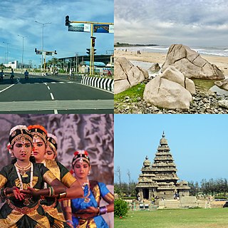
Mamallapuram, is a town in Chengalpattu district in the southeastern Indian state of Tamil Nadu, best known for the UNESCO World Heritage Site of 7th- and 8th-century Hindu Group of Monuments at Mahabalipuram. It is one of the famous tourist sites in India. The ancient name of the place is Thirukadalmallai. It is a part of Chennai Metropolitan Area. It is a satellite town of Chennai.
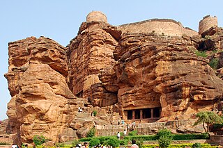
Badami, formerly known as Vātāpi, is a town and headquarters of a taluk by the same name, in the Bagalkot district of Karnataka, India. It was the regal capital of the Badami Chalukyas from 540 to 757. It is famous for its rock cut monuments such as the Badami cave temples, as well as the structural temples such as the Bhutanatha temples, Badami Shivalaya and Jambulingesvara Temple. It is located in a ravine at the foot of a rugged, red sandstone outcrop that surrounds Agastya lake.

The Pataleshwar Caves, also referred to as the Panchaleshvara temple or Bhamburde Pandav cave temple, are an 8th-century rock-cut Hindu temple from the Rashtrakuta period located in Pune, Maharashtra, India. Dedicated to Shiva, it was a monumental monolithic excavation with a notable circular Nandi mandapa and a large pillared mandapa. It is a temple of three rock-cut cave sanctums, likely dedicated to Brahma-Shiva-Vishnu originally, but currently to Parvati-original Shiva-Ganesha. A garden now surrounds the site, new idols have been placed elsewhere in the complex. The interior of the caves have suffered damage from vandalism. Outside, the monument shows the effects of natural elements over the centuries.
Aurangabad district, officially known as Chhatrapati Sambhajinagar district, is one of the 36 districts of the state of Maharashtra in western India. It borders the districts of Nashik to the west, Jalgaon to the north, Jalna to the east, and Ahmednagar to the south. The city of Aurangabad houses the district's administrative headquarters. The district has an area of 10,100 km2, of which 37.55% is urban and the rest is rural. Aurangabad District is a major tourism region in Marathwada, with attractions including the Ajanta Caves and Ellora Caves.
Junnar is a city in the Pune district of the Indian state of Maharashtra. The city has history dating back to the first millennium. The nearby fort of Shivneri was the birthplace of Maratha king Shivaji, the founder of the Maratha Empire. Junnar was declared the first tourism taluka in Pune district by the government of Maharashtra on 9 January 2018.

The Undavalli Caves, a monolithic example of Indian rock-cut architecture and one of the finest testimonials to ancient viswakarma sthapathis, are located in Guntur district in the Indian state of Andhra Pradesh. The caves are located south west of Vijayawada City It is one of the centrally protected monuments of national importance.

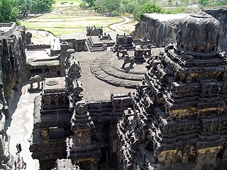
Indian rock-cut architecture is more various and found in greater abundance in that country than any other form of rock-cut architecture around the world. Rock-cut architecture is the practice of creating a structure by carving it out of solid natural rock. Rock that is not part of the structure is removed until the only rock left makes up the architectural elements of the excavated interior. Indian rock-cut architecture is mostly religious in nature.

The Manas River, known in Bhutan as the Drangme Chhu, is a transboundary river in the Himalayan foothills between southern Bhutan, India, and China. It is the largest of Bhutan's four major river systems, with the other three being the Amo Chu or Torsa River, the Wang Chu or Raidak, and the Puna Tshang Chu or Sankosh. It is met by three other major streams before it again debouches into India in western Assam. The river flows for a total length of 400 kilometres (250 mi), including through Tibet for 24 km (15 mi), Bhutan for 272 kilometres (169 mi), and Assam for 104 kilometres (65 mi) before it joins the mighty Brahmaputra River at Jogighopa. A major tributary of the Manas, the Aie River, joins it in Assam at Bangpari.

Naranarayan Setu (IPA - nərəˈna:ra:jənə ˈseɪtu:) is the third bridge to have been constructed over the Brahmaputra River in Assam, India. It is a double-deck bridge with a railway track on the lower deck and a road on the upper deck. It has a length of 2.284 kilometres and connects Jogighopa, a town of Bongaigaon District on the north with Pancharatna, a town of Goalpara District on the south. The bridge was inaugurated on 15 April 1998 by Atal Bihari Vajpayee, the Prime Minister of India at that time. Construction was carried out by the consortium of The Braithwaite Burn and Jessop Construction Company Limited(BBJ). The approximate cost of construction of this bridge is Rs. 301 crore. This bridge is located on route of National Highway 17, erstwhile route NH-37.
Sittanavasal is a small hamlet in Pudukkottai district of Tamil Nadu, India. It is known for the Sittanavasal Cave, a 2nd-century Jain cave complex. From the 7th to the 9th century A.D., the village flourished as a Jain centre.
Golakganj is a railway junction station on the Fakiragram–Dhubri branch line and the New Cooch Behar–Golakganj branch line. A new line is being laid to connect Golakganj with Jogighopa. It is located in Dhubri district in the Indian state of Assam. This station serves the Golakganj town. Important trains like Alipurduar–Silghat Town Rajya Rani Express, Siliguri–Dhubri Intercity Express are available from this station.

The Talaja Caves are located in Bhavnagar district of the Indian state of Gujarat at Talaja. The rock cuts are carved out into deserted conical rocks. The rock cut group include 30 caves among which about 15 are water tanks. The cave has unique architecture known as Ebhal Mandapa. The halls are plain. "On the facade there are chaitya windows with a broad bank below them." The chaitya and cells were carved during a time of Buddhist influence in the 2nd century BC.

There are two sets of Buddhist caves in two different places taking the name of Shana caves.

The Mogalrajapuram Caves are five rock-cut cave temple groups located in different parts of Vijayawada, Andhra Pradesh, India. Dedicated to Shiva, they were excavated during the Eastern Chalukya reign or the Vishnukundins reign. They are generally dated to about the 7th century, after the Akkanna Madanna Caves. They are simple and small, yet the artwork and iconography is more sophisticated than Akkanna Madanna Caves. These include Nataraja, Ganesh and Ardhanarisvara. They are generally numbered as Cave I through V, with Mogalrajapuram Cave II being the most architecturally and iconographically evolved of the five.

Kunnandarkoil Cave Temple in Kunnandarkoil, a village in Pudukottai district in the South Indian state of Tamil Nadu, is dedicated to the Hindu god Shiva. Constructed in Rock-cut architecture, the temple is believed to have been built during the 8th century by Muttaraiyar kings, the cardinals of Pallavas, with later expansion from the Vijayanagar Empire. The rock-cut architecture in the temple is a specimen of the late Pallava Art and an early example of Chola Art. The temple has various inscriptions from Cholas, Chalukyas, Pandyas and Vijayanagar Empire. The temple is considered one of the oldest stone temples in South India. The temple is maintained and administered by Department of Archaeological Survey of India as a protected monument.
Karoh Peak is a 1,467-metre (4,813 ft) tall mountain peak in the Sivalik Hills range of greater Himalayas range located near Morni Hills area of Panchkula district, Haryana, India. It is the highest point in the state of Haryana.

Ancient Indian architecture ranges from the Indian Bronze Age to around 800 CE. By this endpoint Buddhism in India had greatly declined, and Hinduism was predominant, and religious and secular building styles had taken on forms, with great regional variation, which they largely retain even after some forceful changes brought about by the arrival of first Islam, and then Europeans.

The Vijasan Caves are a series of caves containing Buddhist art located near the village of Vijasan in Chandrapur district, Maharashtra, India. Some of the caves at Vijasan have been in use since the 1st century AD. The closest nearby city is Bhadravati.

