
The Willamette River is a major tributary of the Columbia River, accounting for 12 to 15 percent of the Columbia's flow. The Willamette's main stem is 187 miles (301 km) long, lying entirely in northwestern Oregon in the United States. Flowing northward between the Oregon Coast Range and the Cascade Range, the river and its tributaries form the Willamette Valley, a basin that contains two-thirds of Oregon's population, including the state capital, Salem, and the state's largest city, Portland, which surrounds the Willamette's mouth at the Columbia.
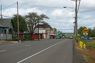
Gaston is a city in Washington County, Oregon, United States. Located between Forest Grove to the north and Yamhill to the south, the city straddles Oregon Route 47 and borders the Tualatin River. Named after railroad executive Joseph Gaston, its population was 637 as of the 2010 census.
The Territory of Oregon was an organized incorporated territory of the United States that existed from August 14, 1848, until February 14, 1859, when the southwestern portion of the territory was admitted to the Union as the State of Oregon. Originally claimed by several countries, the region was divided between the UK and the US in 1846. When established, the territory encompassed an area that included the current states of Oregon, Washington, and Idaho, as well as parts of Wyoming and Montana. The capital of the territory was first Oregon City, then Salem, followed briefly by Corvallis, then back to Salem, which became the state capital upon Oregon's admission to the Union.

The Modoc are a Native American people who originally lived in the area which is now northeastern California and central Southern Oregon. They are currently divided between Oregon and Oklahoma and are enrolled in either of two federally recognized tribes, the Klamath Tribes in Oregon and the Modoc Tribe of Oklahoma, now known as the Modoc Nation.

The Donation Land Claim Act of 1850, sometimes known as the Donation Land Act, was a statute enacted in late 1850 by the United States Congress. It followed the Distribution-Preemption Act 1841. It was intended to promote homestead settlements in the Oregon Territory. The law, a forerunner of the later Homestead Act, brought thousands of white settlers into the new territory, swelling the ranks of settlers traveling along the Oregon Trail. 7,437 land patents were issued under the law, which expired in late 1855. The Donation Land Claim Act allowed white men or partial Native Americans who had arrived in Oregon before 1850 to work on a piece of land for four years and legally claim the land for themselves.

The Willamette Stone was a small stone obelisk originally installed by the Department of Interior in 1885 in the western hills of Portland, Oregon in the United States to mark the intersection and origin of the Willamette meridian and Willamette baseline. It replaced a cedar stake placed by the Surveyor General of the Oregon Territory in 1851; this stake defined the grid system of sections and townships from which all real property in the states of Oregon and Washington has been measured following the Donation Land Claim Act of 1850. The Willamette meridian runs north–south, and the Willamette baseline runs east–west through the marker. The easternmost northeast corner of Washington County is sited on the marker.

The Confederated Tribes of the Grand Ronde Community of Oregon (CTGR) consists of twenty-seven Native American tribes with long historical ties to present-day western Oregon between the western boundary of the Oregon Coast and the eastern boundary of the Cascade Range, and the northern boundary of southwestern Washington and the southern boundary of northern California. The community has an 11,288-acre (45.7 km2) Indian reservation, the Grand Ronde Indian Reservation, which was established in 1855 in Yamhill and Polk counties.

The United States census of 1850 was the seventh census of the United States. Conducted by the Census Office, it determined the resident population of the United States to be 23,191,876—an increase of 35.9 percent over the 17,069,453 persons enumerated during the 1840 census. The total population included 3,204,313 slaves.

Arthur Armstrong Denny was one of the founders of Seattle, Washington, the acknowledged leader of the pioneer Denny Party, and later the city's wealthiest citizen and a 9-term member of the territorial legislature. Seattle's former Denny Hill was named after him; it was flattened in a series of regrading projects and its former site is now known as the Denny Regrade. The city's Denny Way, however, is named not after Arthur Denny, but after his younger brother David Denny.

George Law Curry was a predominant American political figure and newspaper publisher in the region that eventually became the state of Oregon. A native of Pennsylvania, he published a newspaper in St. Louis, Missouri, before traveling the Oregon Trail to the unorganized Oregon Country. A Democrat, Curry served in the new Oregon Territory's government as a representative to the legislature and as Territorial Secretary before appointment as the last Governor of the Oregon Territory. Curry County in Southern Oregon is named in his honor.
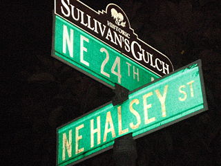
Sullivan's Gulch is a neighborhood in the Northeast section of Portland, Oregon. The name commemorates Timothy Sullivan, an early farmer in the area. Sullivan settled his donation land claim on January 27, 1851. He was born in Ireland in 1805, received citizenship in the United States in 1855, and most likely received title to the claim around 1863.

George Gibbs (1815–1873) was an American ethnologist, naturalist and geologist who contributed to the study of the languages of indigenous peoples in Washington Territory. Known for his expertise in Native American customs and languages, Gibbs participated in numerous treaty negotiations between the U.S. government and the native tribes.

Bethel is an unincorporated community in Polk County, Oregon, United States at the base of the Eola Hills in Plum Valley. Bethel is considered a ghost town as the only remaining structure is a school, now serving as a church. The locale was named by the Rev. Glen O. Burnett for a Church of Christ in Missouri where he had served as pastor. Bethel is a common name for churches as it is a Hebrew word that means "house of god". After traveling with his family on the Oregon Trail, Burnett settled on a Donation Land Claim in 1846. Burnett later rode circuit to the surrounding area, preaching in nearby communities, including Rickreall.
Absalom Jefferson Hembree was an American soldier and politician in what became the state of Oregon. A native of Tennessee, he served in the Provisional Legislature of Oregon and the Oregon Territorial Legislature before being killed in action during the Yakima War.

Fort Umpqua was a trading post built by the Hudson's Bay Company in the company's Columbia District, in what is now the U.S. state of Oregon. It was first established in 1832 and moved and rebuilt in 1836.

Wapato Lake was a historic lake located in what became parts of Washington County and Yamhill County in the U.S. state of Oregon. The area is sometimes known as Wapato Lake Bed and Wapato Flat. The lake bed is located about a half mile east of Gaston at 55 metres (180 ft) elevation. The lake bed soils contain a layer of organic peat that once supported a wetland community dominated by the wapato plant, Sagittaria latifolia, particularly in the upper marsh areas.
The Coast Indian Reservation is a former Indian reservation in the U.S. state of Oregon, established in 1855. It was gradually reduced in size and in the 21st century is known as the present-day Siletz Reservation.

Edward Jay Allen was a pioneer, entrepreneur, and businessman.

Randolph is an unincorporated community in Coos County, Oregon, United States, founded as a "black sand" gold mining boomtown in the 1850s. Although it is considered a ghost town because there are no significant structures left at the site, the USGS classifies Randolph as a populated place. It is on the north bank the Coquille River about 7 miles (11 km) north of Bandon and about 3 miles east of the Pacific Ocean.

Peoria is an unincorporated community and census-designated place (CDP) in Linn County, Oregon, United States. It is on the right bank of the Willamette River at river mile 141 between Eugene and Corvallis. Lacking stores and services, it is a cluster of houses plus a county park along Peoria Road, about 8 miles (13 km) south of Oregon Route 34 and 12 miles (19 km) north of Harrisburg. As of the 2010 census, the population was 94.

