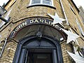
| John Darlington Building | |
|---|---|
 | |
 Interactive map of the John Darlington Building area | |
| General information | |
| Location | Quebec City, Quebec, Canada, 7 Rue de Baude |
| Coordinates | 46°48′48″N71°12′20″W / 46.81341639°N 71.2054397°W |
| Completed | 1775 |
| Technical details | |
| Floor count | 4 |
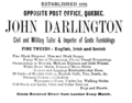
The John Darlington Building is the oldest commercial building in Quebec City, Quebec, Canada. Located at 7 Rue de Buade, at its junction with Rue du Fort, it was built in 1775 for merchant tailor John Darlington. [1] [2]