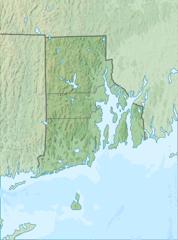
The Narragansett people are an Algonquian American Indian tribe from Rhode Island. Today, Narragansett people are enrolled in the federally recognized Narragansett Indian Tribe. They gained federal recognition in 1983.

The United States Board on Geographic Names (BGN) is a federal body operating under the United States Secretary of the Interior. The purpose of the board is to establish and maintain uniform usage of geographic names throughout the federal government of the United States. Nevertheless, its rulings and policies have been controversial from time to time.

Block Island is an island of the Outer Lands coastal archipelago, located approximately 9 miles (14 km) south of mainland Rhode Island and 14 miles (23 km) east of Long Island's Montauk Point. The island is coterminous with the town of New Shoreham, Rhode Island and is part of Washington County. The island is named after Dutch explorer Adriaen Block, and the town was named for Shoreham, Kent, in England.

Ell Pond is a kettle hole in Hopkinton, Washington County, Rhode Island. It is surrounded by a swamp of red maple and Atlantic white cypress, and by steep granitic monadnocks. The small area contains communities of both hydrophytic and xeric plants, which makes it ideal for ecological research and education. It was designated a National Natural Landmark in May 1974. In 1972, The Nature Conservancy purchased 50 acres (20 ha) including the pond to extend 218 acres (88 ha) of protected land owned by the Audubon Society of Rhode Island and the 1,002 acres (405 ha) of Rockville Wildlife Management Area owned by the state. The preserve is jointly managed by all three entities. There are hiking trails in the preserve, but Ell pond is specifically not reachable due to its fragile environment.
Long Pond is an unincorporated community in Monroe County in the Pocono Mountains region of Pennsylvania, a part of the Appalachian Mountains. Long Pond is located within the Tunkhannock Creek Watershed. Its ZIP code is 18334.

A kettle is a depression or hole in an outwash plain formed by retreating glaciers or draining floodwaters. The kettles are formed as a result of blocks of dead ice left behind by retreating glaciers, which become surrounded by sediment deposited by meltwater streams as there is increased friction. The ice becomes buried in the sediment and when the ice melts, a depression is left called a kettle hole, creating a dimpled appearance on the outwash plain. Lakes often fill these kettles; these are called kettle hole lakes. Another source is the sudden drainage of an ice-dammed lake and when the block melts, the hole it leaves behind is a kettle. As the ice melts, ramparts can form around the edge of the kettle hole. The lakes that fill these holes are seldom more than 10 m (33 ft) deep and eventually fill with sediment. In acidic conditions, a kettle bog may form but in alkaline conditions, it will be kettle peatland.

Fenn's, Whixall and Bettisfield Mosses National Nature Reserve is a national nature reserve (NNR) which straddles the border between England and Wales, near Whixall and Ellesmere in Shropshire, England and Bettisfield in Wrexham County Borough, Wales. It comprises three peat bogs, Bettisfield Moss, Fenn's Moss and Whixall Moss. With Wem Moss and Cadney Moss, they are collectively a Site of Special Scientific Interest called The Fenn's, Whixall, Bettisfield, Wem & Cadney Moss Complex and form Britain's third-largest lowland raised bog, covering 2,388 acres (966 ha). The reserve is part of the Midland Meres and Mosses, an Important Plant Area which was declared a Wetland of International Importance under the Ramsar Convention in 1997. It is also a European Special Area of Conservation.

Located in northern California, the Suisun Marsh has been referred to as the largest brackish water marsh on west coast of the United States of America. The marsh land is part of a tidal estuary, and subject to tidal ebb and flood. The marsh is home to many species of birds and other wildlife, and is formed by the confluence of the Sacramento and San Joaquin rivers between Martinez and Suisun City, California and several other smaller, local watersheds. Adjacent to Suisun Bay, the marsh is immediately west of the legally defined Sacramento-San Joaquin Delta as well as part of the San Francisco Bay estuary.

Rossport is a dispersed rural community and unincorporated place in the Unorganized part of Thunder Bay District in northwestern Ontario, Canada. It is on the north shore of Lake Superior in geographic Lahontan Township, and is on Ontario Highway 17. Rossport is a designated place served by a local services board, and has a population of 65.
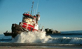
The North Cape oil spill took place on January 19, 1996, when the tank barge North Cape and the tug Scandia grounded on Moonstone Beach in South Kingstown, Rhode Island, after the tug caught fire in its engine room during a winter storm. An estimated 828,000 US gallons (3,130 m3) of home heating oil was spilled. Oil spread throughout a large area of Block Island Sound, including Trustom Pond National Wildlife Refuge, resulting in the closure of a 250-square-mile (650 km2) area of the sound for fishing.

Trustom Pond is a closed lagoon in South Kingstown, Washington County, Rhode Island, United States. It is one of nine coastal lagoons in southern Rhode Island. It has a surface area of 800 acres (320 ha), and is the only undeveloped salt pond in the state. The pond averages 1.3 feet (0.40 m) deep, and has a salinity level of 5 parts per thousand. It is non-tidal, except when breached by storms. The water directly receives about 219,844,022 US gallons (832,200 m3) of precipitation per year, with an estimated 796,215 US gallons (3,014 m3) in daily groundwater flow. No streams flow into the pond, though a nearby stream "captures water that otherwise would have flowed to Trustom Pond".
The John H. Chafee National Wildlife Refuge is a national wildlife refuge of the United States, located along the Narrow River on the southern coast of Rhode Island.
Sandy Point Island is a 35-acre (14 ha) island in Little Narragansett Bay, lying mostly in Westerly, Rhode Island and partly in Stonington, Connecticut. Once an extension of Napatree Point, Sandy Point is now a one-mile-long (1.6 km) island that serves as an important nature preserve and recreation site. Sandy Point is the westernmost piece of land in the state of Rhode Island.

Quicksand Pond is a pond in Little Compton, Rhode Island.

The Narragansett Trail is a 16 miles (26 km) hiking trail located in Connecticut. It is one of the Blue-Blazed Trails maintained by the Connecticut Forest and Park Association, the Narragansett Council, and the Rhode Island chapter of Scouts BSA.

Scudders Falls is an area of whitewater rapids on the Delaware River between Ewing, New Jersey and Lower Makefield, Pennsylvania in the United States. It is popular with local whitewater enthusiasts.

Clark's Mountain is a summit in Clatsop County, Oregon. It is named for William Clark (1770–1838), who during the Lewis and Clark Expedition, likely viewed the summit from the vicinity of Cape Disappointment. It is located in Ecola State Park, 2.4 km northeast of Tillamook Head, 0.8 km south of West Point, 3.5 km southwest of Seaside, Oregon. The summit has an elevation of 355 metres (1,165 ft).
Mashapaug Pond is the largest freshwater pond in the city of Providence, Rhode Island.

The Blackstone Park Conservation District is a public, 45-acre woodland conservation area on the East Side of Providence, Rhode Island. It is run by the non-profit Blackstone Parks Conservancy in partnership with the Providence Parks Department. The park is situated on the west bank of the tidal Seekonk River, the northernmost part of Narragansett Bay tidewater. The park lies within the watershed and wildlife corridor of the Blackstone River Valley. Unlike many city parks, it is actively managed as a preserve for the purpose of providing habitats for wildlife and supporting a healthy ecosystem for native flora and fauna.
Ike's Point is a small, swampy point that protrudes into the western side of Jenkins Sound in Cape May County, New Jersey.