Related Research Articles
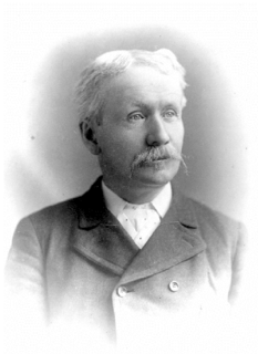
Charles Augustus "Charlie" Semlin was a Canadian politician and rancher.

The Peace River is a 1,923-kilometre-long (1,195 mi) river in Canada that originates in the Rocky Mountains of northern British Columbia and flows to the northeast through northern Alberta. The Peace River joins the Athabasca River in the Peace-Athabasca Delta to form the Slave River, a tributary of the Mackenzie River. The Finlay River, the main headwater of the Peace River, is regarded as the ultimate source of the Mackenzie River. The combined Finlay–Peace–Slave–Mackenzie river system is the 13th longest river system in the world.

Andrew Onderdonk was an American construction contractor who worked on several major projects in the West, including the San Francisco seawall in California and the Canadian Pacific Railway in British Columbia. He was born on August 30, 1848 in New York City, New York to an established ethnic Dutch family. He received his education at the Rensselaer Polytechnic Institute.
Skookum is a Chinook Jargon word that has historical use in the Pacific Northwest. It has a range of meanings, commonly associated with an English translation of "strong" or "monstrous". The word can mean "strong", "greatest", "powerful", "ultimate", or "brave". Something can be skookum, meaning "strong" or "monstrously significant". When used in reference to another person, e.g., "he's skookum", it conveys connotations of reliability or a monstrous nature, as well as strength, size or hard-working.
The 1933 British Columbia general election was the eighteenth general election in the Province of British Columbia, Canada. It was held to elect members of the Legislative Assembly of British Columbia. The election was called on September 13, 1933, and held on November 2, 1933. The new legislature met for the first time on February 20, 1934.

The Rocky Mountain Trench, also known as the Valley of a Thousand Peaks or simply the Trench, is a large valley on the western side of the northern part of North America's Rocky Mountains. The Trench is both visually and cartographically a striking physiographic feature extending approximately 1,600 km (1,000 mi) from Flathead Lake, Montana to the Liard River, just south of the British Columbia–Yukon border near Watson Lake, Yukon. The trench bottom is 3–16 km (1.9–9.9 mi) wide and is 600–900 m (2,000–3,000 ft) above sea level. The general orientation of the Trench is an almost straight 150/330° geographic north vector and has become convenient as a visual guide for aviators heading north or south.

Masset, formerly Massett, is a village in Haida Gwaii in British Columbia, Canada. It is located on Masset Sound on the northern coast of Graham Island, the largest island in the archipelago, and is approximately 50 km (31 mi) west of mainland British Columbia. It is the primary western terminus of Trans-Canada Highway 16 and is served by Masset Airport, with flights to Vancouver and Prince Rupert. During the maritime fur trade of the early 19th century, Masset was a key trading site. It was incorporated as a village municipality on May 11, 1961.
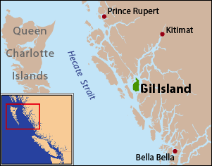
Gil Island is an island on the North Coast of British Columbia, Canada, located on the west side of Whale Channel in the entrance to Douglas Channel, one of the main coastal inlets, on the route of the Inside Passage between Pitt Island and Princess Royal Island. It is 26 km long, with a width ranging from 6 to 13 km, and an area of 231 km2. The only named summit on the mountainous island is Mount Gil, which faces the opening of Douglas Channel.

The Cassiar Mountains are the most northerly group of the Northern Interior Mountains in the Canadian province of British Columbia and also extend slightly into the southernmost Yukon Territory. They lie north and west of the Omineca Mountains, west of the northernmost Rockies and the Rocky Mountain Trench, north of the Hazelton Mountains and east of the Boundary Ranges. They form a section of the Continental Divide, that, in this region, separates water drainage between the Arctic and Pacific Oceans. Physiographically, they are a section of the larger Yukon-Tanana Uplands province, which in turn are part of the larger Intermontane Plateaus physiographic division.

The Lil'wat First Nation, a.k.a. the Lil'wat Nation or the Mount Currie Indian Band, is a First Nation band government located in the southern Coast Mountains region of the Interior of the Canadian province of British Columbia. It is a member of the Lillooet Tribal Council, which is the largest grouping of band governments of the St'at'imc or Stl'atl'imx people. Other St'at'imc governments include the smaller In-SHUCK-ch Nation on the lower Lillooet River to the southwest, and the independent N'quatqua First Nation at the near end of Anderson Lake from Mount Currie, which is the main reserve of the Lil'wat First Nation, and also one of the largest Indian reserves by population in Canada.
Ashcroft Manor Ranch, known also as Ashcroft Ranch, is an historic ranch in the Thompson Country of British Columbia, Canada, founded by Clement Francis Cornwall and his brother, Henry Cornwall. Ashcroft Manor's main house and buildings are an historic site adjacent to the Trans-Canada Highway and the Canadian Pacific mainline, which named its whistlestop at the current site of the village of Ashcroft after it, naming it Ashcroft Station. The Ashcroft Manor is located on the Trans-Canada Hwy #1, at the junction for southern cutoff from the highway to the town of Ashcroft below on the Thompson River.
Simon Gunanoot was a prosperous Gitxsan man and a merchant in the Kispiox Valley region of Hazelton, British Columbia, Canada. He lived with his wife and children on a large ranch. A posse sought him after a murder but he escaped, retrieved his family and hid out. Eventually he surrendered and stood trial. He was found not guilty. The case garnered extensive media coverage and Gunanoot became a figure of legendary status.

Mount Ratz is a mountain located just west of the Stikine River, about 5 km (3 mi) east of the British Columbia-Alaska border. It is the highest peak in the Stikine Icecap and of the Boundary Ranges which in turn form part of the Coast Mountains. It is an extremely high-prominence summit, with a difference in elevation with its "key col" at Hyland Ranch Pass of 2,430 m (7,972 ft). Thus making it one of Canada's Ultra peaks.

Marion was a small sternwheel steamboat that operated in several waterways in inland British Columbia from 1888 to 1901.
Francis Patrick Armstrong was a steamboat captain in the East Kootenay region of British Columbia. He also operated steamboats on the Kootenay River in Montana and on the Stikine River in western British Columbia. Steam navigation in the Rocky Mountain Trench which runs through the East Kootenay region was closely linked to Armstrong's personality and career. In addition to being a steamboat captain, Armstrong was also a prospector, white-water boat pilot and guide in the Big Bend country of the Columbia River.
Fireside is an unincorporated locality on the Alaska Highway in far northern British Columbia, Canada, located at the junction of the Kechika and Liard Rivers. Muddy River Indian Reserve No. 1 is located nearby, as is an old steamer landing named Skooks.
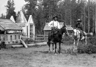
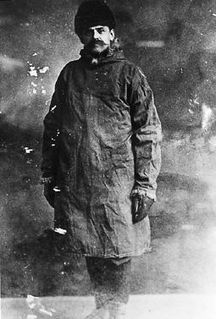
Mount Skook Davidson, 2,382 metres (7,815 ft), is a mountain in the Kechika Ranges of the Cassiar Mountains in far northern British Columbia, Canada. It overlooks the "Diamond J Ranch", which was founded by John Ogilvie Davidson also known as "Skook" Davidson or "Skookum" Davidson because of his stature. Davidson was a notable local pioneer who worked as a land surveyor before taking up packing, guiding, and ranching in this area. He helped discover and select the route for the Alaska Highway.
The Dall River is a river in northern British Columbia, Canada, flowing northwest into the Turnagain River, a tributary of the Kechika, to the west of Mount Skook Davidson. Originally named the Cold Fish River, it was renamed in 1944 to avoid confusion with another river of that name that is a tributary of the Spatsizi, and because of the presence of Dall's sheep in the area. Dall Lake is along its course, south of Dall River Old Growth Provincial Park, which lies between the lake and the confluence with the Turnagain. Denetiah Provincial Park, on the river's upper course, includes Dall Lake.

Kuskanook was a wooden, stern-wheel driven steamboat that operated on Kootenay Lake, in British Columbia from 1906 to 1931. After being taken out of service, Kuskanook was sold for use as a floating hotel, finally sinking in 1936. The vessel name is also seen spelled Kooskanook.
References
- ↑ "Corporal John Ogilvie Davidson".
- ↑ Image - Library and Archives Canada
- ↑ BC Names entry "Mount Skook Davidson"
- ↑ BC Names entry "Skooks Landing"
- ↑ The Newspapering Murrays, Georgina Keddell