Related Research Articles

Captain George Vancouver was a British Royal Navy officer best known for his 1791–1795 expedition, which explored and charted North America's northwestern Pacific Coast regions, including the coasts of what are now the Canadian province of British Columbia as well as the US states of Alaska, Washington, Oregon, and California. He also explored the Hawaiian Islands and the southwest coast of Australia.

Otto von Kotzebue was a Russian naval officer in the Imperial Russian Navy. He commanded two naval expeditions into the Pacific for the purposes of exploration and scientific investigation. The first expedition explored Oceania, the western coast of North America and passed through the Bering Strait in search of a passage across the Arctic Ocean. His second voyage was intended as a military resupply mission to Kamchatka but again included significant explorations of the west coast of North America and Oceania.

John Wesley Powell was an American geologist, U.S. Army soldier, explorer of the American West, professor at Illinois Wesleyan University, and director of major scientific and cultural institutions. He is famous for his 1869 geographic expedition, a three-month river trip down the Green and Colorado rivers, including the first official U.S. government-sponsored passage through the Grand Canyon.
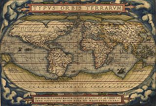
Geographical exploration, sometimes considered the default meaning for the more general term exploration, refers to the practice of discovering remote lands and regions of the planet Earth. It is studied by geographers and historians.
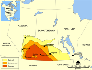
Palliser's Triangle, or the Palliser Triangle, is a semi-arid steppe occupying a substantial portion of the Western Canadian Prairie Provinces, Saskatchewan, Alberta and Manitoba, within the Great Plains region. While initially determined to be unsuitable for crops outside of the fertile belt due to arid conditions and dry climate, expansionists questioned this assessment, leading to homesteading in the Triangle. Agriculture in the region has since suffered from frequent droughts and other such hindrances.

John Septimus Roe was the first Surveyor-General of Western Australia. He was a renowned explorer, a member of Western Australia's legislative and executive councils for nearly 40 years, but also a participant in the Pinjarra massacre on 28 October 1834.

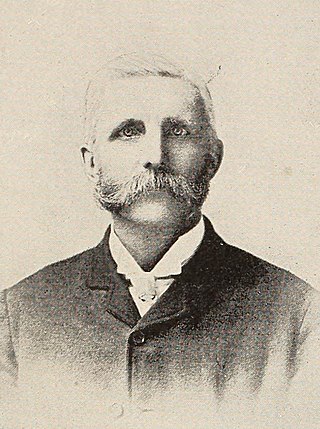
John Palliser was an Irish-born geographer and explorer. Following his service in the Waterford Militia and hunting excursions to the North American prairies, he led the British North American Exploring Expedition which investigated the geography, climate and ecology of what would later become western Canada.

Charles Wilkes was an American naval officer, ship's captain, and explorer. He led the United States Exploring Expedition (1838–1842).

Events from the year 1857 in Canada.

The Palliser expedition, officially the British North American Exploring Expedition, explored and surveyed the open prairies and rugged wilderness of western Canada from 1857 to 1860. The expedition was led by Irish-born explorer John Palliser, and accompanied by a party of four other men: James Hector, Eugène Bourgeau, Thomas Blakiston and John W. Sullivan. With the support of the British government and the Royal Geographical Society it became an official expedition with the stated purpose of gathering scientific information about the landscapes of British-claimed north-western North America, in particular the territory of Rupert's Land, including information on the geography, climate, soil, flora and fauna, in order to discover its capabilities for settlement and transportation.

Marie Byrd Land (MBL) is an unclaimed region of Antarctica. With an area of 1,610,000 km2 (620,000 sq mi), it is the largest unclaimed territory on Earth. It was named after the wife of American naval officer Richard E. Byrd, who explored the region in the early 20th century.

Henry Youle Hind was a Canadian geologist and explorer. He was born in Nottingham, England, and immigrated to Canada, settling in Toronto, Ontario, in 1846. Hind led expeditions to explore the Canadian prairies in 1857 and 1858. In 1857, he explored the Red and Assiniboine River valleys, and in 1858, the Assiniboine, Souris, Qu'Appelle, and South Saskatchewan River valleys. The expeditions are described in his reports Narrative of the Canadian Red River Exploring Expedition of 1857 and Reports of Progress on the Assiniboine and Saskatchewan Exploring Expedition. Hind's activities changed perceptions of the North West and helped open up the Canadian Prairies for agriculture settlement.

Kicking Horse Pass is a high mountain pass across the Continental Divide of the Americas of the Canadian Rockies on the Alberta–British Columbia border, and lying within Yoho and Banff national parks. Divide Creek forks onto both sides of the Continental Divide.

Vice Admiral Sir Henry Kellett, was an Irish naval officer and explorer.

Franklin's lost expedition was a failed British voyage of Arctic exploration led by Captain Sir John Franklin that departed England in 1845 aboard two ships, HMS Erebus and HMS Terror, and was assigned to traverse the last unnavigated sections of the Northwest Passage in the Canadian Arctic and to record magnetic data to help determine whether a better understanding could aid navigation. The expedition met with disaster after both ships and their crews, a total of 129 officers and men, became icebound in Victoria Strait near King William Island in what is today the Canadian territory of Nunavut. After being icebound for more than a year Erebus and Terror were abandoned in April 1848, by which point Franklin and nearly two dozen others had died. The survivors, now led by Franklin's second-in-command, Francis Crozier, and Erebus's captain, James Fitzjames, set out for the Canadian mainland and disappeared, presumably having perished.
The Canadian Arctic Expedition 1913–1916 was a scientific expedition in the Arctic Circle organized and led by Vilhjalmur Stefansson. The expedition was originally to be sponsored by the (US) National Geographic Society and the American Museum of Natural History. Canada took over the sponsorship because of the potential for discovery of new land and Stefansson, who though born in Canada was now an American, re-established his Canadian citizenship. The expedition was divided into a Northern Party led by Stefansson, and a Southern Party led by R M. Anderson.

Arctic exploration is the physical exploration of the Arctic region of the Earth. It refers to the historical period during which mankind has explored the region north of the Arctic Circle. Historical records suggest that humankind have explored the northern extremes since 325 BC, when the ancient Greek sailor Pytheas reached a frozen sea while attempting to find a source of the metal tin. Dangerous oceans and poor weather conditions often fetter explorers attempting to reach polar regions, and journeying through these perils by sight, boat, and foot has proven difficult.

Castle Provincial Park is a provincial park in southern Alberta, Canada. It is located within the Municipal District of Pincher Creek No. 9 south of the Municipality of Crowsnest Pass, northwest of Waterton Lakes National Park and west of the Town of Pincher Creek. It shares a boundary with Castle Wildland Provincial Park to the west and south.
Humphrey Lloyd Hime was an Irish-Canadian photographer, surveyor, businessman, and politician. He accompanied Henry Youle Hind on his 1858 Assiniboine and Saskatchewan Exploring Expedition, which was meant to assess the viability of settling Western Canada. After the expedition, Hime returned to Toronto and continued to work at the firm Armstrong, Beere and Hime, Civil Engineers Draughtsmen, and Photographists, and eventually held several municipal offices. The firm produced the Armstrong, Beere and Hime panorama in 1857, the earliest known photographs of Toronto.

The PEF Survey of Palestine was a series of surveys carried out by the Palestine Exploration Fund (PEF) between 1872 and 1877 for the Survey of Western Palestine and in 1880 for the Survey of Eastern Palestine. The survey was carried out after the success of the Ordnance Survey of Jerusalem by the newly-founded PEF, with support from the War Office. Twenty-six sheets were produced for "Western Palestine" and one sheet for "Eastern Palestine". It was the first fully scientific mapping of Palestine.
References
- ↑ Larmour, Judy (2005), Laying Down the Lines: A History of Land Surveying in Alberta, Brindle and Glass, p. 7, ISBN 978-1-897142-04-2 .
- ↑ Davis, Richard Clarke; Ruggles, Richard I. (1988), Rupert's Land: a cultural tapestry, Calgary Institute for the Humanities Series, Wilfrid Laurier Univ. Press, p. 197, ISBN 978-0-88920-976-3 .
- ↑ Oltmann, Ruth (1997), My Valley: The Kananaskis, Rocky Mountain Books, p. 13, ISBN 978-0-921102-40-3 .
- ↑ Cook, Eung-Do (1984), A Sarcee grammar, UBC Press, p. 3, ISBN 978-0-7748-0200-0 .
- ↑ Spry, Irene M. (1959), "Captain John Palliser and the Exploration of Western Canada", The Geographical Journal, 125 (2): 149–184, doi:10.2307/1790499, JSTOR 1790499 .
| | This article about a Canadian scientist is a stub. You can help Wikipedia by expanding it. |