
Eritrea is located in the Horn of Africa and is bordered on the northeast and east by the Red Sea, on the west and northwest by Sudan, on the south by Ethiopia, and on the southeast by Djibouti. The country has a high central plateau that varies from 1,800 to 3,000 meters (5,906–9,843 ft) above sea level. A coastal plain, western lowlands, and some 350 islands comprise the remainder of Eritrea's land mass.

The United States Virgin Islands are a group of several dozen islands and cays located in the Caribbean, about 1,100 miles (1,770 km) southeast of Florida, 600 miles (966 km) north of Venezuela, 40 miles (64 km) east of Puerto Rico, and immediately west and south of the British Virgin Islands.
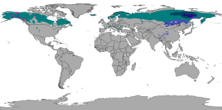
The subarctic climate is a continental climate with long, cold winters, and short, warm to cool summers. It is found on large landmasses, often away from the moderating effects of an ocean, generally at latitudes from 50°N to 70°N, poleward of the humid continental climates. Subarctic or boreal climates are the source regions for the cold air that affects temperate latitudes to the south in winter. These climates represent Köppen climate classification Dfc, Dwc, Dsc, Dfd, Dwd and Dsd.

The United Kingdom straddles the higher mid-latitudes between 49° and 61°N on the western seaboard of Europe. Since the UK is always in or close to the path of the polar front jet stream, frequent changes in pressure and unsettled weather are typical. Many types of weather can be experienced in a single day.

A Mediterranean climate, also called a dry summer climate, described by Köppen as Cs, is a temperate climate type that occurs in the lower mid-latitudes. Such climates typically have dry summers and wet winters, with summer conditions ranging from warm to hot and winter conditions typically being mild to cool. These weather conditions are typically experienced in the majority of Mediterranean-climate regions and countries, but remain highly dependent on proximity to the ocean, altitude and geographical location.

Tropical climate is the first of the five major climate groups in the Köppen climate classification identified with the letter A. Tropical climates are defined by a monthly average temperature of 18 °C (64.4 °F) or higher in the coolest month, featuring hot temperatures and high humidity all year-round. Annual precipitation is often abundant in tropical climates, and shows a seasonal rhythm but may have seasonal dryness to varying degrees. There are normally only two seasons in tropical climates, a wet (rainy/monsoon) season and a dry season. The annual temperature range in tropical climates is normally very small. Sunlight is intense in these climates.
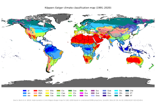
The Köppen climate classification is one of the most widely used climate classification systems. It was first published by German-Russian climatologist Wladimir Köppen (1846–1940) in 1884, with several later modifications by Köppen, notably in 1918 and 1936. Later, German climatologist Rudolf Geiger (1894–1981) introduced some changes to the classification system in 1954 and 1961, which is thus sometimes called the Köppen–Geiger climate classification.

The climate of India consists of a wide range of weather conditions across a vast geographic scale and varied topography. Based on the Köppen system, India hosts six major climatic sub types, ranging from arid deserts in the west, alpine tundra and glaciers in the north, and humid tropical regions supporting rain forests in the southwest and the island territories. Many regions have starkly different microclimates, making it one of the most climatically diverse countries in the world. The country's meteorological department follows the international standard of four seasons with some local adjustments: winter, summer, monsoon or rainy season, and a post-monsoon period.

A humid continental climate is a climatic region defined by Russo-German climatologist Wladimir Köppen in 1900, typified by four distinct seasons and large seasonal temperature differences, with warm to hot summers, and cold and snowy winters. Precipitation is usually distributed throughout the year, but often these regions do have dry seasons. The definition of this climate in terms of temperature is as follows: the mean temperature of the coldest month must be below 0 °C (32.0 °F) or −3 °C (26.6 °F) depending on the isotherm, and there must be at least four months whose mean temperatures are at or above 10 °C (50 °F). In addition, the location in question must not be semi-arid or arid. The cooler Dfb, Dwb, and Dsb subtypes are also known as hemiboreal climates. Although amount of snowfall is not a factor used in defining the humid continental climate, snow during the winter in this type of climate is almost a guarantee, either intermittently throughout the winter months near the poleward or coastal margins, or persistently throughout the winter months elsewhere in the climate zone.
The Poles of Cold are the places in the southern and northern hemispheres where the lowest air temperatures have been recorded.
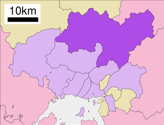
Asakita-ku (安佐北区) is one of the eight wards of the city of Hiroshima.
Karachi has a semi-arid climate, formerly a hot desert climate, albeit a moderate version of this climate, influenced by monsoons. Karachi has a tropical climate, despite being located slightly above the Tropic of Cancer. It is situated in the monsoon region of Pakistan. It is located on the coast bordering the Arabian Sea, and as a result, has a relatively mild climate. However, in more recent years, rainfall has become more abundant. For this reason, the city may be classed as semi-arid (BSh), since it has a mild climate with a short but defined wet season, along with a lengthy dry season.
Singarayakonda is a town in Prakasam district of the Indian state of Andhra Pradesh. It is the mandal headquarters of Singarayakonda mandal. Singarayakonda is located at sea level. It is spread across 10 Grama panchayats. It is under Kandukur Revenue division. Singarayakonda is located 30 kilometers from Ongole. This is situated on the NH-5 Highway and has a connectivity of the Railway line between Vijayawada and Chennai. This gives highest revenue than any other station in this line of South Central Railway in the Prakasam district. This also has been the center for transportation for all the nearby villages which are located around a distance of the 15 kilometres (9.3 mi) from this place.
Tarana is a town and a nagar parishad in Ujjain district in the Indian state of Madhya Pradesh. Tarana is a tehsil in Ujjain and the distance to Ujjain is 34 km. Tarana was part of Holkar estate. The current M.L.A of Tarana constituency is Mahesh Parmar (INC).

The climate of Italy is highly diverse. In most of the inland northern and central regions, the climate ranges from humid subtropical to humid continental and oceanic. The climate of the Po valley geographical region is mostly humid subtropical, with cool winters and hot summers. The coastal areas of Liguria, Tuscany and most of the South experience a Mediterranean climate according to the Köppen climate classification.
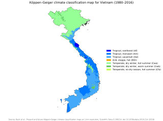
Vietnam has a monsoon-influenced climate typical of that of mainland Southeast Asia. The diverse topography, long latitude, and influences from the South China Sea lead to climatic conditions varying significantly between regions. The northern region experiences a monsoonal and temperate climate (Cfa) with four distinct seasons with winters typically dry and summers ranging from hot to mild. In southern and central areas, the climate is tropical monsoon (Aw) with only two seasons. In addition, a temperate climate exists in mountainous areas, which are found in Sa Pa and Da Lat, while a more continental climate exists in Lai Châu Province and Sơn La Province.

The climate of Wales refers to the weather conditions prevailing in Wales in general or over a long period.
Lakhne Wala is a village of Mandi Bahauddin District in Punjab, Pakistan, located between River Jhelum and River Chenab. The total area of the village is approximately 119,790,000 sq ft or 2750 acres. It is about 8 km east of the city of Mandi Bahauddin. North are Kot Baloch, Rasul and the Government College of Technology, Rasul. It sits at 222 meters (728 feet) in average elevation.

Cyprus has a subtropical climate - Mediterranean and semi-arid type - Csa and BShaccording to Köppen climate classification, with very mild winters on sea level and warm to hot summers. Snow is possible only in the Troodos mountains in the central part of the island. Rain occurs mainly in winter, with summer being generally dry.
The climate of Faisalabad features a semi-arid climate (BSh) in Köppen-Geiger classification, bordering a humid subtropical climate (Cwa) with very hot and humid summers and dry cool winters. The average maximum and minimum temperatures in June are 45.5 °C (113.9 °F) and 26.9 °C (80.4 °F). In January the average minimum and maximum are 19.4 °C (66.9 °F) and 4.1 °C (39.4 °F).