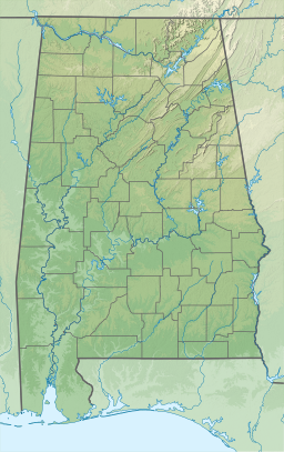
The Alabama River, in the U.S. state of Alabama, is formed by the Tallapoosa and Coosa rivers, which unite about 6 miles (10 km) north of Montgomery, near the town of Wetumpka.

The Coosa River is a tributary of the Alabama River in the U.S. states of Alabama and Georgia. The river is about 280 miles (450 km) long.

Lake Allatoona is a U.S. Army Corps of Engineers reservoir on the Etowah River in northwestern part of the State of Georgia. This reservoir is mostly in southeastern Bartow County and southwestern Cherokee County. A small portion is located in Cobb County near Acworth.

Lake Cumberland is a reservoir in Clinton, Pulaski, Russell, Wayne, and Laurel, counties in Kentucky. The primary reasons for its construction were a means for flood control and the production of hydroelectric power. Its shoreline measures 1,255 miles (2,020 km) and the lake covers 65,530 acres (265 km2) at the maximum power pool elevation. The reservoir ranks 9th in the U.S. in size, with a capacity of 6,100,000 acre-feet (7.5 km3) of water, enough to cover the entire Commonwealth of Kentucky with 3 inches (76 mm) of water. The main lake is 101 miles (163 km) long and over one mile (1.6 km) across at its widest point.

The Tallapoosa River runs 265 miles (426 km) from the southern end of the Appalachian Mountains in Georgia, United States, southward and westward into the Appalachian foothills in Alabama. It is formed by the confluence of McClendon Creek and Mud Creek in Paulding County, Georgia. Lake Martin at Dadeville, Alabama is a large and popular water recreation area formed by a dam on the river. The Tallapoosa joins the Coosa River about 10 miles (16 km) northeast of Montgomery near Wetumpka to form the Alabama River.

Lake Martin is located in Tallapoosa, Elmore and Coosa counties in Alabama. It is a 44,000-acre (178 km2) reservoir with over 750 miles (1,200 km) of wooded shoreline. Lake Martin is a reservoir, enlarged by the construction of Martin Dam on the Tallapoosa River. The Martin Dam powerhouse is used to generate hydroelectric power for the Alabama Power Company. Construction on Martin Dam began in 1923 and was completed in 1926, creating what was, at that time, the largest human-made body of water in the world. Originally known as Cherokee Bluffs for the geological formation upon which it was built, the dam was renamed in 1936 in honor of Thomas Martin, the then-president of Alabama Power Company. Alabama Power and Russell Lands own some of the shoreline.

Guntersville Dam is a hydroelectric dam on the Tennessee River in Marshall County, in the U.S. state of Alabama. It is one of nine dams on the river owned and operated by the Tennessee Valley Authority, which built the dam in the late 1930s as part of a New Deal era initiative to create a continuous navigation channel on the entire length of the river and bring flood control and economic development to the region. The dam impounds the Guntersville Lake of 67,900 acres (27,500 ha), and its tailwaters feed into Wheeler Lake.
Sardis Lake is a 98,520-acre (398.7 km2) reservoir on the Tallahatchie River in Lafayette, Panola, and Marshall counties, Mississippi. Sardis Lake is impounded by Sardis Dam, located nine miles (14 km) southeast of the town of Sardis. It is approximately an hour drive from Memphis, Tennessee. The dam is 15,300 feet (4,700 m) long, has an average height of 97 feet (30 m), and a maximum height of 117 feet (36 m).

Logan Martin Lake is a reservoir located in east central Alabama on the Coosa River approximately 30 miles (48 km) east of Birmingham, Alabama. This 17,000-acre (69 km2) reservoir was built in 1965 by Alabama Power Company. The lake, nicknamed Lake of a Thousand Coves by locals, has 275 miles (443 km) of shoreline along its 48.5-mile (78.1 km) length sandwiched between Logan Martin Dam on the south and Neely Henry Dam on the north. The depth of the lake is 35 to 110 feet (34 m) with only five feet average water level variance.
Neely Henry Lake is located on the Coosa River near Gadsden, Alabama. The lake was formed by the Neely Henry Dam, built in 1966 by Alabama Power Company for hydroelectric power and recreation.

Lewis Smith Lake, also known as Smith Lake, is a reservoir in north Alabama. Located on the Sipsey Fork of the Black Warrior River, it covers over 21,000 acres (85 km2) in Cullman, Walker, and Winston Counties. The maximum depth at the dam is 264 feet (80 m). It is the deepest lake in Alabama. The three-fingered reservoir has over 500 miles (800 km) of shoreline, and at full pool has a level of 510 feet (160 m).

Carters Lake is a man-made reservoir located on the Coosawattee River in the Blue Ridge Mountains in Gilmer and Murray counties in the U.S. state of Georgia. It is the state's deepest lake.
Weiss Lake in northeastern Alabama is owned and operated by the Alabama Power Company. At full summer pool, Weiss Lake sits 564 feet (172 m) above sea level. The lake covers 30,200 acres (122 km2) from the Coosa River, Chattooga River (Alabama–Georgia) and Little River, offering over 447 miles (719 km) of shoreline and shallow flats, large coves, under-water drop offs and deep channels. Weiss Lake also has privately owned hotels, marinas, campground and bait and tackle stores. There are 11 bridges that cross Weiss Lake.
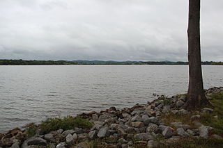
R.E. "Bob" Woodruff Lake is a lake on the Alabama River in central Alabama. Woodruff Lake stretches along 80 miles (130 km) of the Alabama River and has an area of about 20 square miles (52 km2).
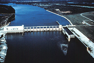
Martin Dam is a concrete arch gravity dam on the Tallapoosa River in Alabama in the United States, about 10 miles (16 km) southwest of Dadeville. Impounding the 40,000-acre (16,000 ha) Lake Martin, the dam was built in the 1920s to provide flood control, hydroelectric power generation and water supply. Originally known as the Cherokee Bluffs dam, the dam is named in honor of Thomas Wesley Martin, president of the Alabama Power Company during the dam's construction. The African American community of Kowaliga was submerged by Lake Martin.
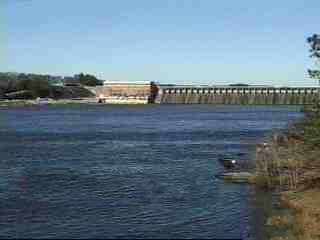
Lay Dam is a hydroelectric power dam on the Coosa River in Chilton County and Coosa County, near Clanton, Alabama.
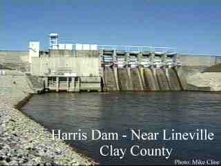
R. L. Harris Dam is a hydroelectric dam in Randolph County, Alabama, the fourth of four such dams on the Tallapoosa River.
Walter Bouldin Dam is a dam in Elmore County, Alabama. The closest town is Wetumpka.

Stony Gorge Dam is a dam in Glenn County, California.
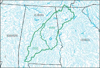
The Alabama-Coosa-Tallapoosa River Basin is a drainage basin (watershed) in the Southeastern United States. The basin is located mainly in eastern Alabama, but also goes includes a small part of Georgia. This area is classified as a sub-region by the USGS hydrological code system.