The British Columbia Hydro and Power Authority, operating as BC Hydro, is a Canadian electric utility in the province of British Columbia. It is the main electricity distributor, serving more than 4 million customers in most areas, with the exception of the City of New Westminster, where the city runs its own electrical department and portions of the West Kootenay, Okanagan, the Boundary Country and Similkameen regions, where FortisBC, a subsidiary of Fortis Inc. directly provides electric service to 213,000 customers and supplies municipally owned utilities in the same area. As a provincial Crown corporation, BC Hydro reports to the BC Ministry of Energy, Mines and Low Carbon Innovation, and is regulated by the British Columbia Utilities Commission (BCUC). Its mandate is to generate, purchase, distribute and sell electricity.
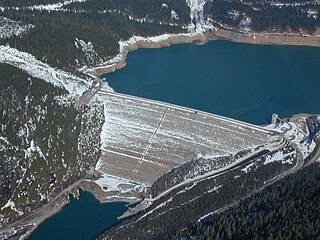
Mica Dam is a hydroelectric embankment dam spanning the Columbia River 135 kilometres north of Revelstoke, British Columbia, Canada. It was built as one of three Canadian projects under the terms of the 1964 Columbia River Treaty and is operated by BC Hydro. Completed in 1973, the Mica powerhouse had an original generating capacity of 1,805 megawatts (MW). Mica Dam, named after the nearby settlement of Mica Creek and its associated stream, in turn named after the abundance of mica minerals in the area, is one of the largest earthfill dams in the world. The reservoir created by the dam is Kinbasket Lake. Water from the dam flows south directly into Revelstoke Lake, the reservoir for the Revelstoke Dam. Mica Dam is the tallest dam in Canada and second tallest in North America after the Chicoasén Dam in Mexico and it is the farthest upstream dam on the Columbia River. The dam's underground powerhouse was the second largest in the world at the time of its construction, and was the first 500 kV installation of sulphur hexafluoride (SF6) insulated switchgear in the world.

Hugh Keenleyside Dam is a flood control dam spanning the Columbia River, 12 km upstream of the city of Castlegar, British Columbia, Canada.

New Bullards Bar Dam is a variable radius concrete arch dam constructed in the early 1960s in California on the North Yuba River. Located near the town of Dobbins in Yuba County, the dam forms the New Bullards Bar Reservoir, which can hold about 969,600 acre⋅ft (1.1960×10⁹ m3) of water. The dam serves for irrigation, drinking water and hydroelectric power generation.

The Bridge River is an approximately 120 kilometres (75 mi) long river in southern British Columbia. It flows south-east from the Coast Mountains. Until 1961, it was a major tributary of the Fraser River, entering that stream about six miles upstream from the town of Lillooet; its flow, however, was near-completely diverted into Seton Lake with the completion of the Bridge River Power Project, with the water now entering the Fraser just south of Lillooet as a result.

Terzaghi Dam is the key diversion dam in BC Hydro's Bridge River Power Project. It forms the project's largest reservoir, Carpenter Lake west of Lillooet. Originally known as the Mission Dam, it was renamed Terzaghi Dam in 1965 to honor Karl von Terzaghi, the civil engineer who founded the science of soil mechanics. It is located about 30 km up the Bridge River from its confluence with the Fraser.

Jordan River, founded as and still officially gazetted as River Jordan, is a small settlement on the west coast of Vancouver Island, British Columbia, Canada, located approximately 70 km (43 mi) west of Victoria.
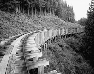
The Bridge River Power Project is a hydroelectric power development in the Canadian province of British Columbia, located in the Lillooet Country between Whistler and Lillooet. It harnesses the power of the Bridge River, a tributary of the Fraser, by diverting it through a mountainside to the separate drainage basin of Seton Lake, utilizing a system of three dams, four powerhouses and a canal.
Run-of-river hydroelectricity (ROR) or run-of-the-river hydroelectricity is a type of hydroelectric generation plant whereby little or no water storage is provided. Run-of-the-river power plants may have no water storage at all or a limited amount of storage, in which case the storage reservoir is referred to as pondage. A plant without pondage is subject to seasonal river flows, thus the plant will operate as an intermittent energy source. Conventional hydro uses reservoirs, which regulate water for flood control, dispatchable electrical power, and the provision of fresh water for agriculture.
Coquitlam Dam is a hydraulic fill embankment dam on the Coquitlam River in the city of Coquitlam, British Columbia. Although it has no powerhouse of its own, its waters divert to Buntzen Lake, making it part of BC Hydro's electrical generation infrastructure. It is also one of the main reservoirs for the Greater Vancouver Water District. BC Hydro has released a new document in March 2018 that addresses emergency preparedness and outlines the areas effected should the dam fail as a result of an extreme earthquake event.

Cougar Dam is a 519-foot (158 m) tall rockfill hydroelectric dam in the U.S. state of Oregon. It has a gated concrete spillway and a powerhouse with two turbines totaling 25 megawatts of electric power.
The Clowhom River is a short, 19.8-kilometre (12.3 mi) river in British Columbia. It flows into the head of the Salmon Inlet about 26.2 km west of Squamish.
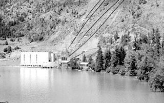
The Goldstream Powerhouse is a decommissioned hydroelectric plant located near Goldstream Provincial Park in Langford, near Victoria, British Columbia. This plant provided electricity to Victoria for 60 years and is one of the little-known and ingenious chapters in the history of Victoria. This plant was one of the first hydro plants of this type on the west coast of North America. The structure is over a century old and is unsafe to inhabit. It is within the boundaries of the watershed lands owned by the CRD and is inaccessible to the public due to its proximity to a drinking water reservoir.

Ruskin Dam is a concrete gravity dam on the Stave River in Ruskin, British Columbia, Canada. The dam was completed in 1930 for the primary purpose of hydroelectric power generation. The dam created Hayward Lake, which supplies water to a 105 MW powerhouse and flooded the Stave's former lower canyon, which ended in a small waterfall approximately where the dam is today.

Stave Falls Dam is a dual-dam power complex on the Stave River in Stave Falls, British Columbia, Canada. The dam was completed in 1912 for the primary purpose of hydroelectric power production. To increase the capacity of Stave Lake, the dam was raised in 1925 and the Blind Slough Dam constructed in an adjacent watercourse 500 m (1,600 ft) to the north, which was the site of the eponymous Stave Falls. In 2000, the dam's powerhouse was replaced after a four-year upgrade. The original Stave Falls powerhouse was once British Columbia's largest hydroelectric power source, and is a National Historic Site of Canada.

Gibson Dam is a concrete arch dam on the Sun River, a tributary of the Missouri River, about 60 miles (97 km) west of Great Falls, Montana in the United States. Located on the eastern edge of the Rocky Mountains, the dam was built by the U.S. Bureau of Reclamation (USBR) between 1926 and 1929 as part of the Sun River Project to develop about 93,000 acres (38,000 ha) of irrigated land in the Sun River Valley.

The Yuba–Bear Hydroelectric Project is a complex hydroelectric scheme in the northern Sierra Nevada in California, tapping the upper Yuba River and Bear River drainage basins. The project area encompasses approximately 400 square miles (1,000 km2) in Nevada, Placer, and Sierra Counties. Owned by the Nevada Irrigation District, it consists of 16 storage dams plus numerous diversion and regulating dams, and four generating stations producing 425 million kilowatt hours of electricity each year. The Yuba–Bear Hydroelectric Project consists of the Bowman development, Dutch Flat No. 2 development, Chicago Park development, and Rollins development.
The John Hart Dam is one of three hydroelectric dams on the Campbell River, located on Vancouver Island in British Columbia, Canada. The dam is located at the outflow of John Hart Lake. The John Hart Generating Station is located nearby.
The Electron Hydroelectric Project, originally known as the Puyallup Project, is a hydroelectric power plant operated by Electron Hydro LLC on the Puyallup River in Pierce County, Washington. It generates 22 megawatts (30,000 hp) of electricity and is operated and maintained by approximately 20 full-time employees.
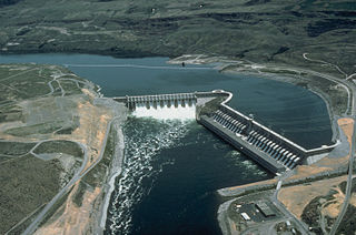
The Kemano Generating Station is situated 75 km (47 mi) southeast of Kitimat in the province of British Columbia, Canada. It was completed in 1954, providing hydroelectricity for Alcan's Kitimat Aluminum smelter. The powerhouse is built in a cavern created 427 m (1,400 ft) inside the base of Mt Dubose. It produces 896 MW of power from its eight generator units, each of which has a capacity of 112 MW. It was the largest producer in the province when it was built, and is now the fifth largest electrical plant in British Columbia.

