
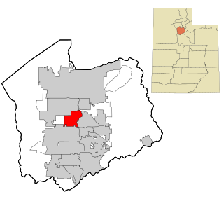
Salt Lake County is located in the U.S. state of Utah. As of the 2020 United States census, the population was 1,185,238, making it the most populous county in Utah. Its county seat and largest city is Salt Lake City, the state capital. The county was created in 1850. Salt Lake County is the 37th most populated county in the United States and is one of four counties in the Rocky Mountains to make it into the top 100. Salt Lake County has been the only county of the first class in Utah – under the Utah Code is a county with a population of 700,000 or greater. Although, Utah County directly to the south has recently reached this threshold.

Kanab is a city in and the county seat of Kane County, Utah, United States. It is located on Kanab Creek just north of the Arizona state line.

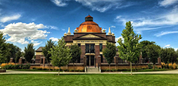
Murray is a city situated on the Wasatch Front in the core of Salt Lake Valley in the U.S. state of Utah. Named for territorial governor Eli Murray, the city had a population of 50,637 as of the 2020 United States Census. Murray shares borders with Taylorsville, Holladay, South Salt Lake, Millcreek and West Jordan, Utah. Once teeming with heavy industry, Murray's industry mix has now shifted significantly toward healthcare, retail, and professional, scientific, and technical services. Known for its central location in Salt Lake County, Murray has been called the Hub of Salt Lake County. Unlike most of its neighboring communities, Murray operates its own police, fire, power, water, library, and parks and recreation departments and has its own school district. While maintaining many of its own services, Murray has one of the lowest city tax rates in the state.
Riverton is a city in Salt Lake County, Utah, United States. It is part of the Salt Lake City metropolitan area. The population was 45,285 as of the 2020 census. Riverton is located in the rapidly growing southwestern corner of the Salt Lake Valley.

Sandy is a city in the Salt Lake City metropolitan area, located in Salt Lake County, Utah, United States. The population was 96,904 according to the 2020 United States Census.

South Jordan is a city in south central Salt Lake County, Utah, United States, 18 miles (29 km) south of Salt Lake City. Part of the Salt Lake City metropolitan area, the city lies in the Salt Lake Valley along the banks of the Jordan River between the 10,000-foot (3,000 m) Oquirrh Mountains and the 11,000-foot (3,400 m) Wasatch Mountains. The city has 3.5 miles (5.6 km) of the Jordan River Parkway that contains fishing ponds, trails, parks, and natural habitats. The Salt Lake County fair grounds and equestrian park, 67-acre (27 ha) Oquirrh Lake, and 37 public parks are located inside the city. As of 2020, there were 77,487 people in South Jordan.
Taylorsville is a city in Salt Lake County, Utah. It is part of the Salt Lake City metropolitan area. The population was 60,448 at the time of the 2020 census. Taylorsville was incorporated from the Taylorsville–Bennion CDP and portions of the Kearns metro township on July 1, 1996. The city is located adjacent to Interstate 215 and Bangerter Highway. It is located in the middle of the Salt Lake Valley.

West Jordan is a city in Salt Lake County, Utah, United States. It is a suburb of Salt Lake City. According to the 2020 Census, the city had a population of 116,961, placing it as the third most populous in the state. The city occupies the southwest end of the Salt Lake Valley at an elevation of 4,330 feet (1,320 m). Named after the nearby Jordan River, the limits of the city begin on the river's western bank and end in the eastern foothills of the Oquirrh Mountains, where Kennecott Copper Mine, the world's largest man-made excavation, is located.

Utah Lake is a shallow freshwater lake in the center of Utah County, Utah, United States. It lies in Utah Valley, surrounded by the Provo-Orem metropolitan area. The lake's only river outlet, the Jordan River, is a tributary of the Great Salt Lake. Evaporation accounts for 42% of the lake's outflow, which leaves the lake slightly saline. The elevation of the lake is at 4,489 feet (1,368 m) above sea level. If the lake's water level rises above that, the pumps and gates on the Jordan River are left open. Recently the lake has been at a lower level because of a drought.

The Jordan River is a 51.4-mile-long (82.7 km) river in the U.S. state of Utah. Regulated by pumps at its headwaters at Utah Lake, it flows northward through the Salt Lake Valley and empties into the Great Salt Lake. Four of Utah's six largest cities border the river: Salt Lake City, West Valley City, West Jordan, and Sandy. More than a million people live in the Jordan Subbasin, part of the Jordan River watershed that lies within Salt Lake and Utah counties. During the Pleistocene, the area was part of Lake Bonneville.

The Utah Transit Authority (UTA) is a special service district responsible for providing public transportation throughout the Wasatch Front of Utah, in the United States, which includes the metropolitan areas of Ogden, Park City, Provo, Salt Lake City and Tooele. It operates fixed route buses, flex route buses, express buses, ski buses, three light rail lines in Salt Lake County (TRAX), a streetcar line in Salt Lake City, and a commuter rail train (FrontRunner) from Ogden through Salt Lake City to Provo. UTA is headquartered in Salt Lake City with operations and garages in locations throughout the Wasatch Front, including Ogden, Midvale and Orem. Light rail vehicles are stored and maintained at yards at locations in South Salt Lake and Midvale. UTA's commuter rail equipment is stored and serviced at a facility in Salt Lake City. In 2023, the system had a ridership of 35,058,000, or about 133,400 per weekday as of the second quarter of 2024.
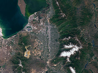
Salt Lake Valley is a 500-square-mile (1,300 km2) valley in Salt Lake County in the north-central portion of the U.S. state of Utah. It contains Salt Lake City and many of its suburbs, notably Murray, Sandy, South Jordan, West Jordan, and West Valley City; its total population is 1,029,655 as of 2010. Brigham Young said, "this is the right place," when he and his fellow Mormon settlers moved into Utah after being driven out of several states.

Area codes 801 and 385 are telephone area codes in the North American Numbering Plan (NANP) serving Salt Lake City and the four surrounding counties of the Wasatch Front in north-central Utah. The numbering plan area comprises Davis, Morgan, Salt Lake, Utah, and Weber counties. Other major towns and cities within the area are Alta, American Fork, Bountiful, Layton, Lehi, Murray, Ogden, Orem, Provo, Sandy, South Jordan, Spanish Fork, Taylorsville, West Jordan, and West Valley City. This numbering plan area is located in the Mountain Time Zone. Area code 801 is one of the original North American area codes created in 1947. Area code 385 was assigned to the same numbering plan area in 2008, creating an overlay complex.
The Central Utah Project is a United States federal water project that was authorized for construction under the Colorado River Storage Project Act of April 11, 1956, as a participating project. In general, the Central Utah Project develops a portion of Utah's share of the yield of the Colorado River, as set out in the Colorado River Compact of 1922.
The High Line Canal (HLC) is a man-made waterway, used for irrigation and recreation, that serves the Denver-Aurora metropolitan area. It begins at a diversion dam on the South Platte River, some 1.8 miles (2.9 km) above the mouth of Waterton Canyon. From its headgate, the HLC runs generally northeast for 66 miles (106 km), passing through Douglas, Arapahoe, Denver, and Adams Counties.
Canyons School District is a school district in the southeastern portion of Salt Lake County in Utah, United States.

Little Cottonwood Creek is one of the principal streams entering Salt Lake Valley from the east. The creek rises near the summit of the Wasatch Mountains, a short distance south of the ski resort town of Alta, and flows in a westerly direction through Little Cottonwood Canyon until it emerges into Salt Lake Valley about eleven miles from its source. Thence its course is north westerly through Sandy, Midvale and Murray, Utah until it empties into the Jordan River, about six miles south of Salt Lake City. Its whole length is nearly 27 miles (43 km). The headwaters of Little Cottonwood Creek are in Little Cottonwood Canyon, a glaciated canyon in Uinta-Wasatch-Cache National Forest and the Wasatch and Uinta Mountains eco-region. One of the main tributaries of the creek rises in Cecret Lake, a small sheet of water situated near Alta. The entire Little Cottonwood Creek drainage basin encompasses 46 square miles (120 km2), ranging in elevation from about 4,490 to 11,500 feet.

Conservation Garden Park is located on the grounds of Jordan Valley Water Conservancy District at 8215 South 1300 West, West Jordan, Utah. The project consists of approximately six acres of demonstration gardens and waterwise landscape exhibits and the new Education Center which was completed and opened to the public in summer 2011. The Center is designed to LEED Platinum standards, showcases environmental building technologies, and broadens the theme of the gardens to include conservation of energy and natural resources.
The Sandy Historic District is a Historic District in Sandy, Utah, United States, that is listed on the National Register of Historic Places (NRHP) and covers most of the city's pre-suburbanization extent.
The Washington County Water Conservancy District (WCWCD) is a water district covering Washington County, Utah. It was formed in 1962 by local petition. The district provides wholesale water to the cities of St. George, Washington, Hurricane, Santa Clara, Ivins, Toquerville, La Verkin, Leeds, and the town of Virgin. The cities are required to engage in water conservation and recycling, and the district is required to develop water sources to meet the needs determined by city governments. The district also supplies drinking water to retail customers in the unincorporated areas of Sky Ranch, Cliffdweller Ranch, Casa de Oro, and (seasonally) Kolob.
