
Cartography is the study and practice of making and using maps. Combining science, aesthetics and technique, cartography builds on the premise that reality can be modeled in ways that communicate spatial information effectively.

The Habsburg monarchy, also known as Habsburg Empire, or Habsburg Realm, was the collection of empires, kingdoms, duchies, counties and other polities that were ruled by the House of Habsburg. From the 18th century it is also referred to as the Austrian monarchy or the Danubian monarchy.
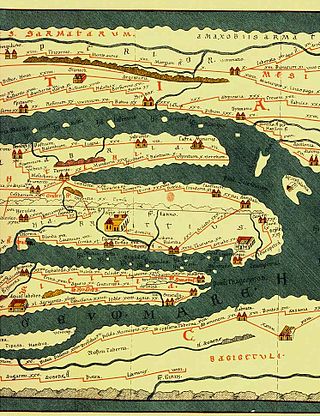
Tabula Peutingeriana, also referred to as Peutinger's Tabula, Peutinger tables or Peutinger Table, is an illustrated itinerarium showing the layout of the cursus publicus, the road network of the Roman Empire.

Szabadegyháza is a village in Fejér county, Hungary.
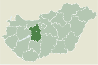
Pázmánd is a village in Fejér county, Hungary. As of 2004, it had 2,015 residents.
Pusztaszabolcs is a town in Fejér County, Hungary.

Archduchess Maria Johanna of Austria was an Archduchess of Austria as the eleventh child of Empress Maria Theresa and Francis I, Holy Roman Emperor. She was originally meant to marry Ferdinand I of the Two Sicilies, however, the marriage plans were never finalised due to Maria Johanna's death due to smallpox.

Giovanni Alessandro Brambilla, Baron of Carpiano was a personal physician of Holy Roman Emperor Joseph II and the first director of the Josephinian Military Academy of Surgery in Vienna.

Blăjeni is a commune in Hunedoara County, Transylvania, Romania. It is composed of eight villages: Blăjeni, Blăjeni-Vulcan, Criș, Dragu-Brad, Groșuri, Plai, Reț and Sălătruc.

A national mapping agency (NMA) is an organisation, usually publicly owned, that produces topographic maps and geographic information of a country. Some national mapping agencies also deal with cadastral matters.

Rut is a village north of Koritnica in the Municipality of Tolmin in the Littoral region of Slovenia.

Forkontumac is a river island in Serbia, located on the Danube, east of Belgrade and north of the neighbouring island Čakljanac. Both islands are the southernmost part of Pančevo. The island has an area of 391,7 hectares. The river mouth of Tamiš into Danube is located north of Forkontumac.

Picturesque Palestine, Sinai, and Egypt was a lavishly illustrated set of books published by D. Appleton & Co. in the early 1880s based on their phenomenally successful Picturesque America and Picturesque Europe series. It was edited by Charles William Wilson, following his leadership of the seminal Ordnance Survey of Palestine and PEF Survey of Palestine. The Appleton series was issued as "two volumes or four divisions"; it was reprinted in London by J.S. Virtue & Co., simply published as four volumes.

The cartography of Jerusalem is the creation, editing, processing and printing of maps of Jerusalem from ancient times until the rise of modern surveying techniques. Most extant maps known to scholars from the pre-modern era were prepared by Christian mapmakers for a Christian European audience.

The Ordnance Survey of Jerusalem of 1864–65 was the first scientific mapping of Jerusalem, and the first Ordnance Survey to take place outside the United Kingdom. It was undertaken by Charles William Wilson, a 28-year-old officer in the Royal Engineers corps of the British Army, under the authority of Sir Henry James, as Superintendent of the Ordnance Survey, and with the sanction of George Robinson, 1st Marquess of Ripon as Secretary of State for War. The team of six Royal Engineers began their work on 3 October 1864. The work was completed on 16 June 1865, and the report was published on 29 March 1866.
The cartography of the region of Palestine, also known as cartography of the Holy Land and cartography of the Land of Israel, is the creation, editing, processing and printing of maps of the region of Palestine from ancient times until the rise of modern surveying techniques. For several centuries during the Middle Ages it was the most prominent subject in all of cartography, and it has been described as an "obsessive subject of map art".

The PEF Survey of Palestine was a series of surveys carried out by the Palestine Exploration Fund (PEF) between 1872 and 1877 for the completed Survey of Western Palestine and in 1880 for the soon abandoned Survey of Eastern Palestine. The survey was carried out after the success of the Ordnance Survey of Jerusalem by the newly-founded PEF, with support from the War Office. Twenty-six sheets were produced for "Western Palestine" and one sheet for "Eastern Palestine". It was the first fully scientific mapping of Palestine.

The 1840–41 Royal Engineers maps of Palestine, Lebanon and Syria was an early scientific mapping of Palestine, Lebanon and Syria.
The Survey of Palestine was the government department responsible for the survey and mapping of Palestine during the British mandate period.

Franz Kuhn von Kuhnenfeld was an Austro-Hungarian military officer who fought against Giuseppe Garibaldi in the wars of Italian independence and served as Imperial and Royal Minister of War from 1868 to 1874. During his term, a unified system of conscription for both Cisleithania and Transleithania was introduced, corporal punishment in military service was abolished, and the Franz-Josephinian Land Survey was initiated. He was a supporter of the Austro-Hungarian polar expedition and an opponent of the Austria-Hungary's 1879 alliance with the German Empire.
