Peñacerrada is a town and municipality located in the province of Álava, in the Basque Country, northern Spain. The Church of Nuestra Señora de la Peña de Faido is located in the town.
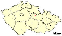
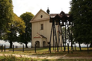
Ostrov is a small village in the Pardubice Region of the Czech Republic. It has 9 inhabitants.
Karłowice is a village in the administrative district of Gmina Olszyna, within Lubań County, Lower Silesian Voivodeship, in south-western Poland.

Kołaczkowo is a village in the administrative district of Gmina Szubin, within Nakło County, Kuyavian-Pomeranian Voivodeship, in north-central Poland. It lies approximately 4 kilometres (2 mi) north-east of Szubin, 18 km (11 mi) south-east of Nakło nad Notecią, and 18 km (11 mi) south-west of Bydgoszcz.
Huta Padniewska is a village in the administrative district of Gmina Mogilno, within Mogilno County, Kuyavian-Pomeranian Voivodeship, in north-central Poland. It lies approximately 7 kilometres (4 mi) west of Mogilno and 54 km (34 mi) south of Bydgoszcz.
Sycyna is a village in the administrative district of Gmina Biała Podlaska, within Biała Podlaska County, Lublin Voivodeship, in eastern Poland. It lies approximately 12 kilometres (7 mi) west of Biała Podlaska and 91 km (57 mi) north of the regional capital Lublin.
Budziski is a village in the administrative district of Gmina Sztabin, within Augustów County, Podlaskie Voivodeship, in north-eastern Poland. It lies approximately 8 kilometres (5 mi) north-west of Sztabin, 15 km (9 mi) south of Augustów, and 69 km (43 mi) north of the regional capital Białystok.
Zawady is a village in the administrative district of Gmina Błaszki, within Sieradz County, Łódź Voivodeship, in central Poland. It lies approximately 4 kilometres (2 mi) east of Błaszki, 20 km (12 mi) west of Sieradz, and 70 km (43 mi) west of the regional capital Łódź.
Chruślina-Kolonia is a village in the administrative district of Gmina Józefów nad Wisłą, within Opole Lubelskie County, Lublin Voivodeship, in eastern Poland.
Oddziały is a part of village Sulborowice in the administrative district of Gmina Fałków, within Końskie County, Świętokrzyskie Voivodeship, in south-central Poland.
Zawierzbie is a village in the administrative district of Gmina Samborzec, within Sandomierz County, Świętokrzyskie Voivodeship, in south-central Poland. It lies approximately 4 kilometres (2 mi) east of Samborzec, 6 km (4 mi) south-west of Sandomierz, and 82 km (51 mi) east of the regional capital Kielce.
Moszyny is a village in the administrative district of Gmina Bogoria, within Staszów County, Świętokrzyskie Voivodeship, in south-central Poland. It lies approximately 2 kilometres (1 mi) east of Bogoria, 13 km (8 mi) north-east of Staszów, and 54 km (34 mi) south-east of the regional capital Kielce.
Malawa is a village in the administrative district of Gmina Krasne, within Rzeszów County, Subcarpathian Voivodeship, in south-eastern Poland. It lies approximately 3 kilometres (2 mi) south of Krasne and 7 km (4 mi) east of the regional capital Rzeszów.
Staszów is a village in the administrative district of Gmina Kozienice, within Kozienice County, Masovian Voivodeship, in east-central Poland. It lies approximately 6 kilometres (4 mi) east of Kozienice and 85 km (53 mi) south-east of Warsaw.
Łebień is a village in the administrative district of Gmina Nowa Wieś Lęborska, within Lębork County, Pomeranian Voivodeship, in northern Poland. It lies approximately 10 kilometres (6 mi) north of Nowa Wieś Lęborska, 11 km (7 mi) north of Lębork, and 67 km (42 mi) north-west of the regional capital Gdańsk.
Logovardi is a village situated in Pelagonia, east of Bitola, Republic of Macedonia. Located in the village of Logovardi is the cemetery of the buried French soldiers, who lost their lives during World War II. France had deployed many soldiers, to help Yugoslavia during the Nazi invasions of Europe.
Kursi is a village in Tapa Parish, Lääne-Viru County, in northeastern Estonia.
Paluküla is a village in Kehtna Parish, Rapla County in northern-central Estonia.
Mustla is a village in Saaremaa Parish, Saare County in western Estonia.
Ridala is a village in Saaremaa Parish, Saare County in western Estonia.


