Related Research Articles

The Guiana Shield is one of the three cratons of the South American Plate. It is a 1.7 billion-year-old Precambrian geological formation in northeast South America that forms a portion of the northern coast. The higher elevations on the shield are called the Guiana Highlands, which is where the table-like mountains called tepuis are found. The Guiana Highlands are also the source of some of the world's most well-known waterfalls such as Angel Falls, Kaieteur Falls and Cuquenan Falls.
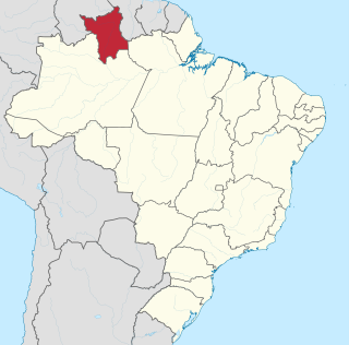
Roraima is one of the 26 states of Brazil. Located in the country's North Region, it is the northernmost and most geographically and logistically isolated state in Brazil. It is bordered by the state of Pará to the southeast, Amazonas to the south and west, Venezuela to the north and northwest, and Guyana to the east.
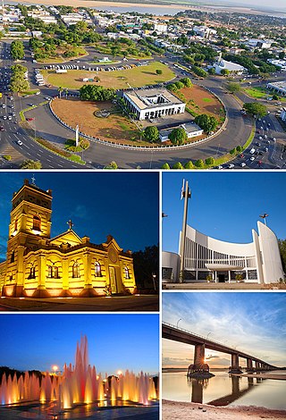
Boa Vista is the capital of the Brazilian state of Roraima. Situated on the western bank of the Branco River, the city lies 220 km (140 mi) from Brazil's border with Venezuela. It is the only Brazilian state capital located entirely north of the equator.
Micrandra is a plant genus of the family Euphorbiaceae first described in 1854. It is native to South America.

The golden-winged parakeet is a species of bird in the family Psittacidae, the true parrots.

The violaceous jay is a species of bird in the family Corvidae, the crows and their allies.
Nhamundá River or Jamundá River is a river in northern Brazil, which marks part of the northeastern boundary between states of Amazonas and Pará. The 300 km long Nhamundá River originates in the plateau Serra do Jatapu near the division of the Brazilian States of Roraima, Amazonas and Pará, and from there it flows in a southeastern direction, forming the natural division between Amazonas and Pará. It then crosses the Nhamundá-Mapuera Reserve (EG033) before joining the Trombetas River near the city of Oriximiná. The river, which flows through the Lago Nhamundá, is the last major right-hand affluent of the Trombetas River before the Trombetas joins the Amazon River. The mouth is located about 480 km east of Manaus.
Alalaú River is a river forming part of the border between the Amazonas and Roraima states in north-western Brazil, a tributary of the Jauaperi River.
The Jauaperi River is a river of Amazonas state in northwestern Brazil, a tributary of the Rio Negro.
The Ajarani River is a river of Roraima state in northern Brazil.
The Branquinho River is a river of Roraima state in northern Brazil.
The Catrimani River is a river of Roraima state in northern Brazil.
The Furo Santa Rosa is a river of Roraima state in northern Brazil. It is an anabranch - a diversionary channel - of the Uraricoera River; together they bound the Ilha de Maracá.
The Macucuaú River is a river of Roraima state in northern Brazil.
The Traida River is a river of Roraima state in northern Brazil.
The Xeriuini River is a river located in the Roraima state in northern Brazil.
The Água Boa do Univini River is a river of Roraima state in northern Brazil.
In 2011, the Campeonato Brasileiro Série D, the fourth division of the Brazilian League, will be contested for the third time in history, during 18 July and 13 November. It will be contested by 40 clubs, four of which will eventually qualify to the Campeonato Brasileiro Série C to be contested in 2012.
The Waimiri-Atroari or Uaimiris-Atroari are an indigenous group inhabiting the southeastern part of the Brazilian state of Roraima and northeastern Amazonas, specifically the Waimiri Atroari Indigenous Territory. They call themselves Kinja people.
References
Coordinates: 1°13′S61°59′W / 1.217°S 61.983°W