Related Research Articles
Fruit Cove is a census-designated place (CDP) in St. Johns County, Florida, United States. The population was 16,077 at the 2000 census. It is located in the community of St. Johns.
Summit Metro Parks is a Metroparks system serving the citizens of Summit County, Ohio by managing 14,000 acres (5,700 ha) in 16 developed parks, six conservation areas and more than 150 miles (240 km) of trails, with 22.4 miles (36.0 km) of the Ohio & Erie Canal Towpath Trail.

The 74-mile-long (119 km) Ocklawaha River flows north from central Florida until it joins the St. Johns River near Palatka. Its name is derived from ak-lowahe, Creek for "muddy".

Switzerland is an unincorporated community in northwest St. Johns County, Florida, United States, adjacent to Fruit Cove.
Julington Creek Plantation is an unincorporated community in the larger community of St. Johns, St. Johns County, Florida, United States. It consists of several large neighborhoods, and is located along Race Track Road east of State Road 13, across from Fruit Cove.
Mandarin is a neighborhood located in the southernmost portion of Jacksonville, in Duval County, Florida, United States. It is located on the eastern banks of the St. Johns River, across from Orange Park. It's a short drive south of Jacksonville's city center, and is bordered by Beauclerc to the north, Julington Creek to the south and St. John's River to the west.
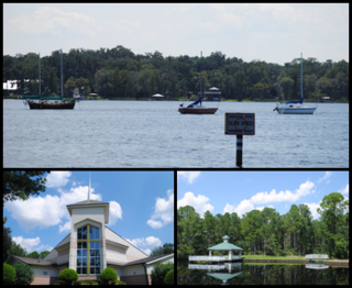
Saint Johns is an unincorporated community in northwest St. Johns County, Florida, United States and a suburb of Jacksonville. The population as of the 2000 census was 18,063, though considerable growth has taken place in the past ten years. As of 2016, the population is estimated to be approximately 86,400 people. It is located in the Jacksonville metropolitan area, and lies approximately halfway between downtown Jacksonville and downtown St. Augustine.

The Trout River is a 20-mile-long (32 km) tributary of the St. Johns River in Duval County, Florida. Located entirely within Jacksonville's Northside area, the river is brackish in its lower section. The widest point of the river is near the St. Johns River, where it is 0.6 miles (1.0 km) across. The Trout River has wetlands as far as the mouth of the river's longest tributary, the Ribault River.
The Econlockhatchee River is an 87.7-kilometer-long (54.5 mi) north-flowing blackwater tributary of the St. Johns River. The Econ River flows through Osceola, Orange, and Seminole counties in Central Florida, just east of the Orlando Metropolitan Area. It is a designated Outstanding Florida Waters.
The Buffalo Creek and Gauley Railroad (BC&G) was a railroad chartered on April 1, 1904 and ran along Buffalo Creek in Clay County, West Virginia. The original Buffalo Creek and Gauley ended service in 1965.

St. Johns County School District (SJCSD) is the public school district for St. Johns County, Florida.
Hal Scott Regional Preserve and Park is a 9,515-acre (38.51 km2) nature preserve located along the banks of the Econlockhatchee River in east Orange County, Florida, United States. The Preserve is bordered by the Econlockhatchee on the West and Wedgefield, Florida on the East. It is managed by the St. Johns River Water Management District and Orange County Parks and Recreation. Recreational amenities include camping, hiking, horseback riding, mountain biking, fishing, and wildlife viewing.
Blackwater Creek is an approximately 19 mile riverine feature in Florida. The creek flows from Lake Norris and has a confluence with the Wekiva River near where it in turn flows into the St. Johns River. The upper sections of Black Creek are traversed by kayak and canoe. Other sections a difficult to navigate due to snags.
Deep Creek Conservation Area is an area of protected lands near Hastings, Florida in St. Johns County and Putnam County that is managed by the St. Johns River Water Management District.
Deep Creek State Forest (DCSF) is a 380-acre state forest 11 miles north of St. Augustine, Florida in St. Johns County, Florida. Deep Creek State Forest is located on both sides of Deep Creek, for which it is named. The state forest is west of the Guana River Wildlife Management Area across the Intracoastal Waterway.
Ferncliff Forest is a 200-acre (0.81 km2) old-growth forest preserve of deciduous and hemlock trees located in Rhinebeck, a town in the northern part of Dutchess County, New York, USA. The property had been bought in 1900 by John Jacob Astor IV and remained in the Astor family until 1964, when it was donated as a forest preserve and game refuge.
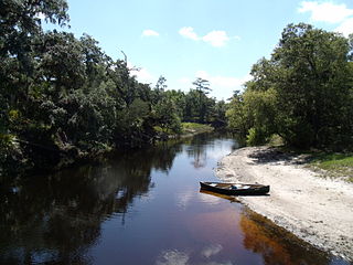
Julington Creek is a stream in Duval County, Florida, near Jacksonville. Durbin Creek is a tributary. Julington Creek feeds into the St Johns River widening out into Old Bull Bay. Both are navigable by paddlecraft and has a marina on it.
References
- ↑ Recreation Guide to District Lands, Julington-Durbin Preserve. http://www.sjrwmd.com/recreationguide/julington-durbin/ Retrieved on Sept 15, 2013.