Related Research Articles

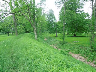
Fort Ancient is a Native American earthworks complex located in Washington Township, Warren County, Ohio, along the eastern shore of the Little Miami River about seven miles (11 km) southeast of Lebanon on State Route 350. The site is the largest prehistoric hilltop enclosure in the United States with three and one-half miles (18,000 ft) of walls in a 100-acre (0.40 km2) complex. Built by the Hopewell culture, who lived in the area from the 200 BC to AD 400, the site is situated on a wooded bluff 270 feet (82 m) above the Little Miami. It is the namesake of a culture known as Fort Ancient who lived near the complex long after it was constructed.

Hopewell Culture National Historical Park is a United States national historical park with earthworks and burial mounds from the Hopewell culture, indigenous peoples who flourished from about 200 BC to AD 500. The park is composed of six separate sites in Ross County, Ohio, including the former Mound City Group National Monument. The park includes archaeological resources of the Hopewell culture. It is administered by the United States Department of the Interior's National Park Service.

Fortified Hill Works is a registered historic site near Hamilton, Ohio, listed in the National Register on July 12, 1974.

The Alligator Effigy Mound is an effigy mound in Granville, Ohio, United States. The mound is believed to have been built between AD 800 and 1200 by people of the Fort Ancient culture. The mound was likely a ceremonial site, as it was not used for burials.
The Newark Earthworks in Newark and Heath, Ohio, consist of three sections of preserved earthworks: the Great Circle Earthworks, the Octagon Earthworks, and the Wright Earthworks. This complex, built by the Hopewell culture between 100 BCE and 400 CE, contains the largest earthen enclosures in the world, and was about 3,000 acres in total extent. Less than 10 percent of the total site has been preserved since European-American settlement; this area contains a total of 206 acres (83 ha). Newark's Octagon and Great Circle Earthworks are managed by the Ohio History Connection. A designated National Historic Landmark, in 2006 the Newark Earthworks was also designated as the "official prehistoric monument of the State of Ohio."

The Hopeton Earthworks are an Ohio Hopewell culture archaeological site consisting of mounds and earthwork enclosures. It is located on the eastern bank of the Scioto River just north of Chillicothe in Ross County, Ohio, about 1 mile (1.6 km) east of the Mound City Group and Shriver Circle on a terrace of the Scioto River. The site is a detached portion of the Hopewell Culture National Historic Park, along with the Mound City Group, Hopewell Mound Group, Seip Earthworks, Spruce Hill Earthworks and the High Bank Works. The site is open to the public.

The Tremper Mound and Works are a Hopewell earthen enclosure and large, irregularly shaped mound. The site is located in Scioto County, Ohio, about five miles northwest of Portsmouth, Ohio, on the second terrace floodplain overlooking the Scioto River. It was listed on the National Register of Historic Places in 1972.

The Portsmouth Earthworks are a large prehistoric mound complex constructed by the Native American Adena and Ohio Hopewell cultures of eastern North America. The site was one of the largest earthwork ceremonial centers constructed by the Hopewell and is located at the confluence of the Scioto and Ohio Rivers, in present-day Ohio.
The Mount Horeb Earthworks Complex is an Adena culture group of earthworks in Lexington, Kentucky. It consists of two major components, the Mount Horeb Site 1 and the Peter Village enclosure, and several smaller features including the Grimes Village site, Tarleton Mound, and Fisher Mound. The Peter Village and Grimes Village enclosures were mapped by Rafinesque and featured in Squier and Davis's landmark publication Ancient Monuments of the Mississippi Valley in 1848 as Plate XIV Figures 3 and 4.

The Biggs site (15Gp8), also known as the Portsmouth Earthworks Group D, is an Adena culture archaeological site located near South Shore in Greenup County, Kentucky. Biggs was originally a concentric circular embankment and ditch surrounding a central conical burial mound with a causeway crossing the ring and ditch. It was part of a larger complex, the Portsmouth Earthworks located across the Ohio River, now mostly obliterated by agriculture and the developing city of Portsmouth, Ohio.

The Marietta Earthworks is an archaeological site located at the confluence of the Muskingum and Ohio Rivers in Washington County, Ohio, United States. Most of this Hopewellian complex of earthworks is now covered by the modern city of Marietta. Archaeologists have dated the ceremonial site's construction to approximately 100 BCE to 500 CE.
Indian Mound Reserve is a public country park near the village of Cedarville, Ohio, United States. Named for two different earthworks within its bounds — the Williamson Mound and the Pollock Works — the park straddles Massies Creek as it flows through a small canyon.

Fort Hill State Memorial is a Native American earthwork located in Highland County, Ohio, United States. Built by the Hopewell culture, it is maintained by the Arc of Appalachia Preserve System and the Ohio History Connection.
Howard Baum Site is a Hopewell tradition earthworks site located in Ross County, Ohio, in the United States. The work is located near the north fork of Paint Creek. It was described, in 1848, as "one of the largest and most interesting in the Scioto valley."

Cedar-Bank Works is group of Adena culture earthworks located in Ross County, Ohio in the United States. It is located approximately five miles north of the town of Chillicothe, Ohio.
The Dunlap Works are a group of Hopewell tradition earthworks located in Ross County, Ohio in the United States. It is located approximately 6 miles (9.7 km) north of the city of Chillicothe, Ohio on the left bank of the Scioto River. The site should not be confused with the earthworks in Hamilton County on the Great Miami River near Dunlap's Station, the former site of a pioneer fort.

The Piketon Mounds are a group of earthworks located in Piketon, Ohio in the United States. The site is listed on the National Register of Historic Places. The specific age of the site is unknown. Some mounds were created by the Adena culture, while other mounds were built by the Hopewell culture.

Cross Mound is an earthwork located near Tarlton, Ohio in the United States. The culture who built it and the time it was built remains unknown. It is listed on the National Register of Historic Places. Contemporary archaeologists have described it as "one of the many enigmatic effigy mounds in Southern Ohio."

The Stubbs Earthworks was a massive Ohio Hopewell culture archaeological site located in Morrow in Warren County, Ohio.

The Shriver Circle Earthworks are an Ohio Hopewell culture archaeological site located in Chillicothe in Ross County, Ohio. At 1,200 feet (370 m) in diameter the site is one of the largest Hopewell circular enclosures in the state of Ohio.
References
- ↑ "What is the Junction Group". Earthworks Conservancy. Retrieved 2014-03-26.[ permanent dead link ]
- 1 2 3 4 5 6 Ephraim George Squier; Edwin Hamilton Davis (1848). Ancient Monuments of the Mississippi Valley. Smithsonian Institution. pp. 153–158.
- ↑ Romain, William F.; Jarrod Burks (2008). "LiDAR Analyses of Prehistoric Earthworks in Ross County, Ohio". Articles and Abstracts. Ohio Archaeological Society. Retrieved 30 July 2013.