
The East Walker River is an approximately 90 miles (140 km) long, tributary of the Walker River, in eastern California and western Nevada in the United States. It drains part of the eastern side of the Sierra Nevada in the watershed of Walker Lake in the Great Basin. Recently boated successfully. The river provides continuous Class IV for kayaks and IK at high water. Be aware many ranchers have placed barbed wire illegally across the river in a number of places on both the CA and NV sides of the river.

Donner Lake is a freshwater lake in Northeast California on the eastern slope of the Sierra Nevada and about 20 miles (32 km) northwest of the much larger Lake Tahoe. A moraine serves as a natural dam for the lake. The lake is located in the town of Truckee, between Interstate 80 to the north and Schallenberger Ridge to the south. The tracks of the Union Pacific Railroad run along Schallenberger Ridge and closely follow the route of the original transcontinental railroad. The historic route of the Lincoln Highway, the first automobile road across America and US 40 follows the northern shoreline, then climbs to Donner Pass from where the entire lake may be viewed.

The cutthroat trout(Oncorhynchus clarkii) is a fish species of the family Salmonidae native to cold-water tributaries of the Pacific Ocean, Rocky Mountains, and Great Basin in North America. As a member of the genus Oncorhynchus, it is one of the Pacific trout, a group that includes the widely distributed rainbow trout. Cutthroat trout are popular gamefish, especially among anglers who enjoy fly fishing. The common name "cutthroat" refers to the distinctive red coloration on the underside of the lower jaw. The specific name clarkii was given to honor explorer William Clark, coleader of the Lewis and Clark Expedition.

Convict Lake is a lake located in Mono County, California, United States, situated in the Sherwin Range of the Sierra Nevada mountains. It is known for its turquoise-blue water, the dramatic mountains that surround it, the trout fishing it affords, and its unusual history. The lake, known to the Paiute as Wit-sa-nap, was renamed by settlers after an incident on September 23, 1871, in which a group of convicts escaped from prison in Carson City, Nevada, and took refuge near the lake. They were pursued by a posse, and after it caught up to the convicts, a shootout followed, in which a number of both posse members and convicts were killed or wounded. The remaining convicts who survived initially escaped but were eventually captured and lynched.
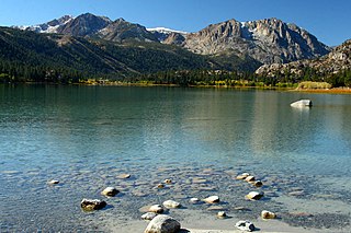
June Lake is a subalpine lake within the Inyo National Forest, in Mono County, eastern California. It is at an elevation of 7,621 ft (2,323 m) in the Eastern Sierra Nevada.

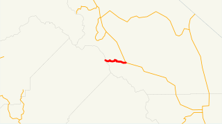
State Route 266 is a state highway in the U.S. state of California. The route traverses Fish Lake Valley, which is part in California and part in Nevada. The route connects two Nevada state routes that traverse the Nevada portion of the valley, NV 264 and NV 266. The only connection from SR 266 to the rest of California's road network is via SR 168 in the community of Oasis. Prior to 1986 the southern and northern halves of modern SR 266 had separate numerical designations. The southern portion of the highway, along with modern SR 168, dates to the auto trail era, forming part of the Midland Trail.

For the trail's section in West Virginia see: The Midland Trail in West Virginia.

State Route 158 is a state highway in the U.S. state of California. Known as the June Lake Loop, it is a loop route of U.S. Route 395 in Mono County that serves the community of June Lake.
State Route 203 is a state highway in the U.S. state of California that basically serves as a spur route from U.S. Route 395 in Mono County to the town of Mammoth Lakes and Minaret Summit. Within Mammoth Lakes, State Route 203 is known as both "Minaret Road" and "Main Street." It connects to Lake Mary and the Mammoth Scenic Loop via secondary roads.

The Trinity Alps Wilderness is a 525,627-acre (212,714 ha) designated wilderness located in northern California, roughly between Eureka and Redding. It is jointly administered by Shasta-Trinity, Klamath, and Six Rivers National Forests. About 4,623 acres (1,871 ha) are administered by the Bureau of Land Management. The wilderness is located in the Salmon and Scott Mountains, subranges of the Klamath Mountains region. The high, granitic and ultramafic peaks of the eastern half of the wilderness area are known as the Trinity Alps. Granite peaks at the core of the area are known as the White Trinities, reddish ultramafic peaks in the southeast are known as the Red Trinities, and the forested mountains in the western half of the wilderness are known as the Green Trinities.

Topaz Lake is a reservoir located on the California-Nevada border, about 75 miles (121 km) south of Reno. The census-designated place of Topaz Lake, Nevada, is located along its northwest shore.

San Leandro Creek is a 21.7-mile-long (34.9 km) year-round natural stream in the hills above Oakland in Alameda County and Contra Costa County of the East Bay in northern California.
U.S. Route 395 (US 395) is a United States Numbered Highway, stretching from Hesperia, California to the Canadian border in Laurier, Washington. The California portion of US 395 is a 557-mile (896 km) route which traverses from Interstate 15 (I-15) in Hesperia, north to the Oregon state line in Modoc County near Goose Lake. The route clips into Nevada, serving the cities Carson City and Reno, before returning to California.

June Lake is a census-designated place in Mono County, California. It is located against the southern rim of the Mono Basin, 12.5 miles (20 km) south of Lee Vining, at an elevation of 7654 feet.

Rush Creek is a 27.2-mile-long (43.8 km) creek in California on the eastern slope of the Sierra Nevada, running east and then northeast to Mono Lake. Rush Creek is the largest stream in the Mono Basin, carrying 41% of the total runoff. It was extensively diverted by the Los Angeles Aqueduct system in the twentieth century until California Trout, Inc., the National Audubon Society, and the Mono Lake Committee sued Los Angeles Department of Water and Power (LADWP) for continuous low flows in Rush Creek to maintain trout populations in good condition, which was ordered by the court in 1985.

The Fish Lake Valley is a 25 miles (40 km) long endorheic valley in southwest Nevada, one of many contiguous inward-draining basins collectively called the Great Basin. The alluvial valley lies just northwest of Death Valley and borders the southeast, and central-northeast flank of the massif of the White Mountains of California. The valley's southern end lies in eastern Inyo County, California. The valley is sparsely populated with ranchers and indigenous Paiute. Business services are located in the valley's only town, Dyer.

Queechy Lake is a lake in Canaan, Columbia County, New York. Situated near the Massachusetts state border, the lake is 40 feet (12 m) deep and contains a surface area of 141 acres (0.57 km2). The name comes from the Native American Mahican name Quis-sich-kook, of unknown meaning.

Mono Village is a former settlement in Mono County, California. It was located 11 miles (18 km) southwest of Bridgeport, at an elevation of 7142 feet. It is currently a vacation destination that attracts hundreds of fishermen and outdoor enthusiasts every year. It is a full service destination with a camp ground, motel, cabins, grocery store, cafe, and other amenities. The main attraction is the two lakes known as Twin Lakes. Both of these lakes are filled with water from Robinson's Creek which flows down from the top of the mountains and ends at the Bridgeport Reservoir. It has some of the best trout fishing in California with record size fish being caught there. Both lakes have boat access and the Upper Twin allows for water sports. Mono Village is also a starting off point for many back country hiking trails. It sits on the back side of Yosemite which makes it attractive to expert backpackers and horseback tours.
Oasis is an unincorporated community in Mono County, California. It is located in Fish Lake Valley 20 miles (32 km) east-southeast of Mount Bancroft. Oasis is at the junction of California State Route 266 and California State Route 168. The 2000 Census reports that Oasis had a population of 22.

The Fish River chain of lakes is a series of five lakes in the North Maine Woods region of northern Maine, in a tributary stream to the Fish River. The lakes are an important northern Maine recreation area providing habitat for wildlife including rainbow smelt, brook trout, lake trout, and land-locked Atlantic salmon.

