Related Research Articles

Saxton is a borough in Bedford County, Pennsylvania, United States. The population was 726 at the 2020 census.
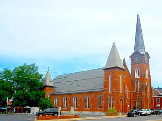
Huntingdon is a borough in and county seat of Huntingdon County, Pennsylvania, in the Middle Atlantic states region of the Northeastern United States. It is located along the Juniata River, approximately 32 miles (51 km) east of larger Altoona and 92 miles (148 km) west of the state capital of Harrisburg on the Susquehanna River. With a population of 6,827 in the 2020 U.S. Decennial Census, it is the largest population center near Raystown Lake, a winding, 28-mile-long (45 km) flood-control reservoir managed by the United States Army Corps of Engineers.
Penn Township is a township in Huntingdon County, Pennsylvania, United States. The population was 1,078 at the 2020 census. The township includes the village of Hesston and the Seven Points Marina of Raystown Lake.
Huntingdon and Broad Top Mountain Railroad (H&BTM) is a former short line railroad company operating passenger and freight service on standard gauge track in south central Pennsylvania.
Midlothian is an unincorporated community and census-designated place (CDP) in Allegany County, Maryland, United States; at one time it was called Midlothian Junction. As of the 2010 census it had a population of 320. Its ZIP code is 21543.

Pennsylvania Route 26 is a 125.5-mile (202.0 km) highway in the south-central area of Pennsylvania. Its northern terminus is at PA 150 northwest of Howard; its southern terminus is at the Maryland state line near Barnes Gap in Union Township. Two major destinations along this route are Raystown Lake near Huntingdon and the Pennsylvania State University at State College.
The Bellefonte Central Railroad was a shortline connecting Bellefonte and State College, Pennsylvania. Constructed in the late 19th century to haul local iron ore to furnaces in the Bellefonte region, it later hauled freight traffic to Penn State and lime for steelmaking from local quarries. The line to State College was abandoned in 1974, and most of the remaining railroad in 1984, but a small portion is still used by the Nittany and Bald Eagle Railroad.
The Catasauqua and Fogelsville Railroad was built in the 1850s to transport iron ore from local mines in Lehigh and later Berks County to furnaces along the Lehigh River in eastern Pennsylvania. Originally owned by two iron companies, the railroad later became part of the Reading Company, and parts of it remain in operation today.
The Central Railroad of Pennsylvania was a short railroad of 27.3 miles (43.9 km) built to connect Bellefonte, Pennsylvania with the Beech Creek Railroad at Mill Hall, Pennsylvania. Sustained by shipments from the Bellefonte iron industry, the abandonment of the iron furnaces there led to its demise in 1918.

Trough Creek State Park is a 554 acres (224 ha) Pennsylvania state park in Cass, Penn and Todd Townships, Huntingdon County, Pennsylvania in the United States. The majority of the park is in Todd Township along Pennsylvania Route 994, east of the unincorporated village of Entriken. Huntingdon is the nearest borough. The park borders Rothrock State Forest and Raystown Lake National Recreation Area. There is a growing population of bald eagles at the lake. Fourteen eagles were spotted in January 2007. This is up from two that were spotted in 1990, the first year that an eagle survey was taken. These three sections of state and federal owned property combine together to provide hunting, hiking and fishing opportunities for the outdoorsman.
The Tuscarora Valley Railroad was a 3 ft narrow gauge short-line railroad that operated in central Pennsylvania from 1891 to 1934.

Tussey Mountain is a stratigraphic ridge in central Pennsylvania, United States, trending east of the Bald Eagle, Brush, Dunning and Evitts Mountain ridges. Its southern foot just crosses the Mason–Dixon line near Flintstone, Maryland, running north 130 km (80 mi) to the Seven Mountains of central Pennsylvania, near Tusseyville, making it one of the longest named ridges in this section of the Ridge-and-valley Appalachians.
The Georges Creek Coal and Iron Company is a defunct coal mining, iron producer and railroad company that operated in Maryland from 1835 to 1863.

Bedford County, Pennsylvania is situated along the western border of the Ridge and Valley physiographic province, which is characterized by folded and faulted sedimentary rocks of early to middle Paleozoic age. The northwestern border of the county is approximately at the Allegheny Front, a geological boundary between the Ridge and Valley Province and the Allegheny Plateau.

The Altoona and Beech Creek Railroad was a 3 ft narrow gauge railroad in Pennsylvania that operated during the late ninteeth and early twentieth centuries. It carried passenger traffic from the vicinity of Altoona to Wopsononock and coal and timber from Wopsononock and Dougherty to Altoona.

The Ironton Railroad was a shortline railroad in Lehigh County, Pennsylvania. Originally built in 1861 to haul iron ore and limestone to blast furnaces along the Lehigh River, traffic later shifted to carrying Portland cement when local iron mining declined in the early 20th century. Much of the railroad had already been abandoned when it became part of Conrail in 1976, and the last of its trackage was removed in 1984.
Hesston is an unincorporated community in Penn Township of Huntingdon County, Pennsylvania, United States. Also located in Hesston is Raystown Lake. Hesston is the home of the Hesston Speedway. The community was originally called Pleasant Grove and Grafton, but renamed Hesston.

The Buffalo and Susquehanna Railroad was a railroad company that formerly operated in western and north central Pennsylvania and western New York. It was created in 1893 by the merger and consolidation of several smaller logging railroads. It operated independently until 1929, when a majority of its capital stock was purchased by the Baltimore and Ohio Railroad. At the same time, the B&O also purchased control of the neighboring Buffalo, Rochester, and Pittsburgh Railway. The Baltimore and Ohio officially took over operations of both roads in 1932.
The Woodward Iron Company was founded on December 31, 1881, by brothers William and Joseph Woodward. William was the company president and Joseph was the company secretary. The company operated iron and coal mines, quarries and furnaces; these were connected by a private industrial railroad based in Bessemer, Alabama. The company administrative office was located near Woodward Ore Mine #1, south of Paul's Hill in Bessemer.
Alexander Alan Arthur was a Scottish-born engineer and entrepreneur active primarily in the southeastern United States in the latter half of the 19th century. Flamboyant, charismatic, and energetic, Arthur used his prominent American and European financial connections to fund numerous business ventures, most of which were overly ambitious and ultimately failed. A proponent of economic advancement in what became known as the New South, Arthur played a primary role in the development of the Cumberland Gap area, and in the course of his endeavors established the cities of Middlesboro, Kentucky and Harrogate, Tennessee. The community of Arthur, Tennessee, is named for him.
References
- 1 2 3 Rainey, Lee; Kyper, Frank (1996) [1982]. East Broad Top. San Marino, California: Golden West Books. pp. 108–109. ISBN 0-87095-078-9.
- 1 2 Morgan, Ronald L.; Baughman, Jon D. (1992). "The Juniata & Southern Railroad". From Coal to Glory: The History of the Huntingdon & Broad Top Mountain Railroad & Coal Co. Vol. II.
- ↑ "Hiking at Raystown Lake". Archived from the original on 2006-03-27. Retrieved 2006-10-08.