
Tiruchirappalli, is a major tier II city in the Indian state of Tamil Nadu and the administrative headquarters of Tiruchirappalli district. The city is credited with being the best livable and the cleanest city of Tamil Nadu, as well as the fifth safest city for women in India. It is the fourth largest city as well as the fourth largest urban agglomeration in the state. Located 322 kilometres (200 mi) south of Chennai and 374 kilometres (232 mi) north of Kanyakumari, Tiruchirappalli sits almost at the geographic centre of Tamil Nadu state. The Cauvery Delta begins 16 kilometres (9.9 mi) west of the city where the Kaveri river splits into two, forming the island of Srirangam which is now incorporated into the Tiruchirappalli City Municipal Corporation. The city occupies an area of 167.23 square kilometres (64.57 sq mi) and had a population of 916,857 in 2011.
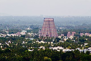
Srirangam is a neighbourhood in the city of Tiruchirappalli in the Indian state of Tamil Nadu. A river island, Srirangam is bounded by the Kaveri River on one side and its distributary Kollidam on the other side. Considered as the first among the 108 Divya Desams, a group of Vishnu temples, it is famous for the Ranganathaswamy Temple, the largest temple complex in India and the biggest functioning Hindu temple in the world. Srirangam is also home to a significant population of Sri Vaishnavas.

Bharathidasan University (BDU) is a university in the city of Tiruchirappalli, Tamil Nadu, India. It is located on Tiruchirappalli-Pudukkottai National Highway 336. It has affiliated colleges in the districts of Ariyalur district, Karur, Nagapattinam, Perambalur, Pudukkottai, Thanjavur, Tiruvarur and Tiruchirapalli. It is a recognised university, supported by the University Grants Commission of India. All major faculties of science and arts are represented. The university has totally 4 Faculties, 16 Schools, 37 Departments and 29 Specialized Research Centres.
K.K. Nagar is a neighbourhood located in the southern part of Chennai, India. This is situated west of Ashok Nagar and the Chennai Airport is around 10 km southwest of this place. K.K. Nagar was a locality developed in the 1970s and early 1980s. K.K. Nagar is roughly 5 km2 in area. K.K. Nagar is organized by sectors and streets, and there are 15 sectors, and around 102 streets.
Karumathampatti is a Municipality in the Coimbatore district in the state of Tamil Nadu, India. It is one of the prominent developing suburb in Coimbatore metropolitan area, about 25 km away from the city centre. It is situated in between NH544 which connects the city of Coimbatore with Salem – Erode – Tirupur and also in between the State Highway 165 connects Annur – Kamanaikenpalayam. Nearby places are Somanur-3 km, Avinashi-10 km, Tirupur-20 km, Sulur-15 km, Annur-16 km. Coimbatore -27,Mettupalayam-38,Palladam-19. Karumathampatti lies near the junction of two major roads, NH544(Coimbatore – Salem) and Karumathampatti – Annur road.
Thammampatti is a Town Panchayat in the Gangavalli taluk of Salem District of Tamil Nadu, India. The town is located between Pachamalai and the Kolli Hills on the banks of the River Swetha bordering Tiruchirappalli district, and is known mainly for its fine wood carvings.
Thiruverumbur is a neighbourhood in the city of Tiruchirapalli in the Indian state of Tamil Nadu. It was merged with the Tiruchirappalli Corporation in 2011.
Located in the Indian state of Tamil Nadu, Vinayagapuram is a northern region of Chennai city's Chennai district.
Pettavaithalai is a panchayat town in Srirangam taluk Tiruchirappalli district in the Indian state of Tamil Nadu.

Tiruchirappalli has a well-developed transport infrastructure. Being located almost at the geographic centre of the state Tamil Nadu India, Tiruchirappalli is well connected by Road, Rail and Air with most cities.

Thanjavur has a well-developed transport infrastructure. Thanjavur is well connected by Road, and Rail with most cities and towns in India
Edamalaipatti Pudur or E.Pudur is a large residential neighbourhood and extension of Tiruchirappalli in Tamil Nadu, India. Surrounded by KK Nagar to East, Karumandapam to West, Crawford to North & Panjapur to South. The areas has amenities such as Popular Temples, hospitals,smart mediequip services, Pazhamudircholai, tailors, flour mills, schools and petrol stations.

Thuvarankurichi is a town in Tiruchirappalli district in the Chola Nadu region of the Indian state of Tamil Nadu. It is situated 65 kilometers away from both Tiruchirappalli and Madurai. The town is located within the drainage basin of the Vellar River Raja college of Allied Health Science and Hotel Management College located at Thuvarankurichi.

Madurai in Southern Tamil Nadu, India, has well-developed transport facilities. Modes of transport in Madurai include road, rail and air. Madurai faces increasing daily traffic problems, so master plans have been prepared to reduce the city traffic and traffic problems in suburbs.
Central Bus Station, popularly known as Central Bus Stand, is one of the bus termini of Trichy, located near Cantonment, the other being the Chatram Bus Stand.
Thirudesamalai or Thiruthiyamalai, is a village in Tiruchirappalli District in the Indian state of Tamil Nadu.
The town of Viluppuram in the Indian state of Tamil Nadu is well connected by both rail and road to other major cities in the state including Chennai, Trichy, Madurai, Salem, Thanjavur, Coimbatore, Dindigul and Vellore. And also other state major cities such as Bengaluru, Tirupati, Pondicherry and Mangalore. Viluppuram serves as one of the important railway junction of Tamil Nadu and Southern Railway Zone. The nearest domestic airport is Pondicherry, which has a daily chartered flight to Bengaluru. The nearest international airports are Chennai and Tiruchirappalli.
People see Madurai Metro DPR & efforts from the Government of TN, as an eyewash. Madurai Metro rail is a hot subject for all the political parties & not for the people. If one party does not talk about metro rail, other party will claim that they brought metro rail. People of Madurai are well aware of this. Madurai is not an industrial town & economics will not viable for that investment.
