
Chiba Prefecture is a prefecture of Japan located in the Kantō region of Honshu. Chiba Prefecture has a population of 6,278,060 and has a geographic area of 5,157 km2 (1,991 sq mi). Chiba Prefecture borders Ibaraki Prefecture to the north, Saitama Prefecture to the northwest, and Tokyo to the west.
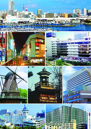
Funabashi is a city located in Chiba Prefecture, Japan. As of 1 December 2020, the city had an estimated population of 644,668 in 309,238 households and a population density of 7,500 inhabitants per square kilometre (19,000/sq mi). The total area of the city is 85.62 square kilometres (33.06 sq mi). It is the Greater Tokyo Area's 7th most populated city, and second largest in Chiba Prefecture.
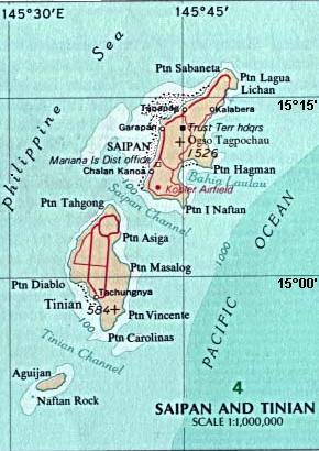
Tinian is one of the three principal islands of the Commonwealth of the Northern Mariana Islands (CNMI). Together with uninhabited neighboring Aguiguan, it forms Tinian Municipality, one of the four constituent municipalities of the Northern Marianas. Tinian's largest village is San Jose. Tinian is just south of the Northern Marianas' most inhabited island, Saipan, but north of the populated Rota to the south. The island has many World War II historical sites, cattle ranches, and beaches. There was a 5-star casino that operated from 1998 to 2015; the remaining are other hotels/resorts and a golf course. The main Saipan access is a short airplane ride from the international airport or a charter boat.

Ichikawa is a city in western Chiba Prefecture, Japan. As of 31 January 2024, the city had an estimated population of 492,749 in 256,229 households and a population density of 8577 persons per km2. The total area of the city is 57.45 square kilometres (22.18 sq mi). The city has good transportation connections to the center of Tokyo, as with many areas of Chiba Prefecture. Major rail routes and roads pass through the city.

Nakatsu is a city on the northern border of Ōita Prefecture in Kyushu, Japan. As of 31 October 2023, the city had an estimated population of 82,301 in 41222 households, and a population density of 96 persons per km2. The total area of the city is 491.53 km2 (189.78 sq mi).

Nichinan is a city in Miyazaki Prefecture, Japan. As of 1 May 2023, the city had an estimated population of 47,872 in 21482 households, and a population density of 89 persons per km². The total area of the city is 536.11 km2 (206.99 sq mi).

Dalka ogadenOgaden (Somali: Deegaanka Soomaalida, Amharic: ሱማሌ ክልል, romanized: Sumalē Kilil, Arabic: المنطقة الصومالية), also known as Ogadenia (Soomaali Galbeed) (lit. 'Western Somalia') and officially the Somali Regional State, is a regional state in eastern Ethiopia. Its territory is the largest. The regional state borders the Ethiopian regions of Afar and Oromia to the west, as well as Djibouti to the north, Somalia to the northeast, east and south; and Kenya to the southwest.
The Movement for the Survival of the Ogoni People (MOSOP), is a social movement organization representing the indigenous Ogoni people of Rivers State, Nigeria. The Ogoni contend that Shell Petroleum Development Company (SPDC), along with other petroleum multinationals and the Nigerian government, have destroyed their environment, polluted their rivers, and provided no benefits in return for enormous oil revenues extracted from their lands.

The Tugen are a sub tribe of the Kenyan Kalenjin people. They fall under the highland nilotes category. They occupy Baringo County and some parts of Nakuru County and Elgeyo Marakwet County in the former Rift Valley Province. Daniel Arap Moi, the second president of Kenya (1978–2002), came from this sub-tribe. The Tugen people speak the Tugen language. The Tugen population was 197,556 as of 2019.

Payakumbuh is the second largest city in West Sumatra province, Indonesia, with a population of 116,825 at the 2010 Census and 139,576 at the 2020 Census; the official estimate as at mid 2023 was 144,830 - comprising 72,840 males and 71,990 females. It covers an area of 80.42 km² and is in the Minangkabau Highlands, 120 km by road from the West Sumatran capital city of Padang and 180 km from the Riau capital city of Pekanbaru.

The Ogoni is an ethnic group located in Rivers South-East senatorial district of Rivers State, in the Niger Delta region of southern Nigeria. They number just over 2 million and live in a 1,050-square-kilometre (404-square-mile) homeland which they also refer to as Ogoniland. They share common oil-related environmental problems with the Ijaw people of the Niger Delta.

East Kazakhstan Region is a region of Kazakhstan. It occupies the easternmost part of Kazakhstan, and includes parts of the Irtysh River, Lake Markakol, and Lake Zaysan. Its administrative center is Öskemen. The region borders Altai Krai and Altai republic in Russia in the north and northeast and the People's Republic of China, via Xinjiang, in the south and southeast. The easternmost point of the Oblast is within about 50 kilometres of the westernmost tip of Mongolia; however, Kazakhstan and Mongolia do not share a common border, the two countries being separated by a small part of Russia and China.
The Elgeyo are an ethnic group who are part of the larger Kalenjin ethnic group of Nilotic origin. They live near Eldoret, Kenya, in the highlands of the former Keiyo District, now part of the larger Elgeyo Marakwet County. The Elgeyo originally settled at the foothills of the Elgeyo escarpment, in the area between Kerio river to the east and the escarpment to the west. Due to drought and famine in the valley, the Keiyos climbed the escarpment and started to settle on the highland east of Uasin Gishu plateau. When the British came, the Keiyos were pushed to settle in clusters called reserves.

The Turu are an ethnic and linguistic group based in the Singida Region of north-central Tanzania who speak Bantu language Kinyaturu. In 1993, the Turu population was estimated to number 556,000. The current population of the Turu is now over 1,000,000. They speak the Turu language.
Chiba is the capital city of Chiba Prefecture, Japan. It sits about 40 kilometres (25 mi) east of the centre of Tokyo on Tokyo Bay. The city became a government-designated city in 1992. In December 2024, its population was 985,059, with a population density of 3,605 people per km2. The city has an area of 271.77 square kilometres (104.93 sq mi).

Chandoli National Park is a national park established in Sangli district in May 2004. Earlier it was a Wildlife Sanctuary declared in 1985. Chandoli Park is notable as the southern portion of the Sahyadri Tiger Reserve, with Koyna Wildlife Sanctuary forming the northern part of the reserve

Gongshan Derung and Nu Autonomous County is an autonomous county located in Nujiang Lisu Autonomous Prefecture, in the northwest of Yunnan province, China. It has an area of 4,506 km2 (1,740 sq mi) and a population of about 37,894 according to the 2010 Census. The county government is stationed in Cikai Town

North Padang Lawas is a landlocked regency in the North Sumatra province of Indonesia. It has an area of 3,918.05 km2, and had a population of 223,049 at the 2010 census and 260,720 at the 2020 census; the official estimate as of mid-2023 was 275,448. North Padang Lawas Regency was created on 17 July 2007 from the eastern parts of the South Tapanuli Regency. Its administrative seat is the town of Gunung Tua.

Abel Kirui is a long-distance runner from Kenya who competes in marathons. He had back-to-back wins in the World Championship marathon in 2009 and 2011. Kirui won in 2009 with a time of 2:06:54, then defended his title with a winning margin of two minutes and 28 seconds – the largest ever margin at the World Championship event. He earned the silver medal in the 2012 London Olympic marathon.
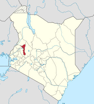
Elgeyo-Marakwet County is one of Kenya's 47 counties. Located in the former Rift Valley Province, its capital and largest town is Iten. It borders the counties of West Pokot to the north, Baringo County to the east, southeast and south, Uasin Gishu to the southwest and west, and Trans Nzoia to the northwest.