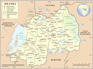
Rwanda is located in East Africa, to the east of the Democratic Republic of the Congo, at the co-ordinates 2°00′S30°0′E.

The Ruzizi is a river, 117 kilometres (73 mi) long, that flows from Lake Kivu to Lake Tanganyika in Central Africa, descending from about 1,500 metres (4,900 ft) to about 770 metres (2,530 ft) above sea level over its length. The steepest gradients occur over the first 40 kilometres (25 mi), where hydroelectric dams have been built. Further downstream, the Ruzizi Plain, the floor of the Western Rift Valley, has gentle hills, and the river flows into Lake Tanganyika through a delta, with one or two small channels splitting off from the main channel.

The Burundi Ministry of Energy and Mines also known as the Ministry of Hydraulics, Energy and Mines is responsible for managing energy development and distribution in Burundi. The main function of the Ministry of Energy and Mines include: design and implement the National policy in energy, geology and Mines; promote geological research and mining industry activities; developing and implementing policies related to electricity, minerals, petroleum and petroleum products. The current Cabinet Minister of Energy is Hon. Ibrahim Uwizeye, Jiji and Mulembwe Hydropower Project (PHJIMU), Hydro-Electric Plant Mpanda, Hydro-Electric Plant Kabu 16, Hydro-Electric Plant Rusumo falls, Kagu Project, Ruzizi III, Ruvyironza, Hydro-Electric Plant in Kirasa-Karonge, Peat Power Project.

The Nyabarongo is a major river in Rwanda, part of the upper headwaters of the Nile. With a total length of 351 km (218 mi), it is the longest river entirely in Rwanda. It is extended 421 km (262 mi) in Lake Rweru including a 69 km (43 mi) upper course of Kagera River before joining into Ruvuvu River to form the Kagera River. The river begins its course at the confluence of the rivers Mbirurume and Mwogo in the South West of the country. These two rivers themselves begin in Nyungwe Forest, and are considered by some to be the most distant source of the Nile. From its start, Nyabarongo flows northward for 85 km, and forms the border between the Western and Southern Provinces. At the confluence with the river Mukungwa, the river changes course and flows eastward for 12 km, then to a more South Eastern course for the last 200 km. For the longest stretch of this course, the river serves as the boundary between the Northern and Southern Provinces, then between the City of Kigali and the Southern Province, and lastly between the City of Kigali and the Eastern Province.

The Congo–Nile Divide or the Nile–Congo Watershed is the continental divide that separates the drainage basins of the Congo and Nile rivers. It is about 2,000 kilometres (1,200 mi) long.
Ruzizi III Hydroelectric Power Station is a proposed hydropower plant with planned capacity installation of 206 MW when completed.
Ruzizi IV Hydroelectric Power Station, is a proposed hydro-power plant, with planned capacity installation of 287 megawatts (385,000 hp) when completed.
Kabu 16 Hydroelectric Power Station is a 20 megawatts (27,000 hp) hydroelectric power station in Burundi. It was developed by the government of Burundi, with funding from the Exim Bank of India. Construction began in March 2019 and was completed in October 2024. It was formerly opened on October 25, 2024.
Rwegura Hydroelectric Power Station is a 18 megawatts (24,000 hp) hydroelectric power station in the Cibitoke Province of Burundi.
Ruzizi II Hydroelectric Power Station is a 44 megawatts (59,000 hp) hydroelectric power station on the Rusizi River between Rwanda and the Democratic Republic of the Congo
Ruzizi I Hydroelectric Power Station is a 29.8 megawatts (40,000 hp) hydroelectric power station on the Rusizi River between Rwanda and the Democratic Republic of the Congo
Ruvyironza Hydroelectric Power Station is an 0.8 megawatts (1,100 hp) run-of-the-river hydroelectric power station in the Muyinga Province of Burundi.
The Kitenge River, or Gitenge Rver, is a river in northwestern Burundi.
The Kagunuzi River is a river in northwestern Burundi.
The Mpanda River is a river in Bubanza Province, Burundi. It is a tributary of the Ruzizi River.
The Nyamagana River is a river in Cibitoke Province, Burundi. It is a tributary of the Ruzizi River.
The Muhira River is a river in Cibitoke Province, Burundi. It is a tributary of the Ruzizi River.
The Mwogere River is a river in Kayanza Province, Burundi, a right tributary of the Akanyaru River.


