
The Cangallo Province is a province located in the Ayacucho Region of Peru. It is one of the eleven that make up the region. The province has a population of 36,977 inhabitants as of census 2005. The capital of the province is the city of Cangallo.

The Yauyos Province is a province located in the Lima Region of Peru. It is one of the eleven that make up that region.

The Tayacaja Province is one of seven provinces located in the Huancavelica Region of Peru. The capital of this province is the city of Pampas. The province has a population of 116,371 inhabitants as of 2002.

Víctor Fajardo Province is a province in the centre of the Ayacucho Region in Peru.

The Castrovirreyna Province is one of seven provinces located in the Huancavelica Region of Peru. The capital of this province is the city of Castrovirreyna.

Urubamba Province is one of thirteen provinces in the Cusco Region in the southern highlands of Peru.

Santiago de Lucanamarca District is one of four districts of the province Huanca Sancos in Peru.
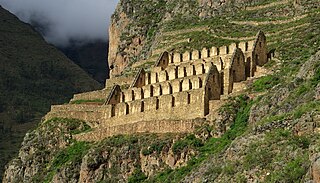
Ollantaytambo District is one of seven districts of the province Urubamba in Peru.
Huachocolpa District is one of nineteen districts of the province Huancavelica in Peru.

Huancavelica District is one of nineteen districts of the province Huancavelica in Peru.
Lircay District is one of twelve districts of the Angaraes Province in Peru.

The Chonta mountain range lies in the Huancavelica Region in the Andes of Peru. It extends between 12°37' and 13°07'S and 75°00' and 75°30'W for about 50 km. It is located in the Castrovirreyna Province and in the Huancavelica Province.
Kachimayu is a river in Peru located in the Huancavelica Region, Huancavelica Province, on the border of the districts of Ascensión and Huancavelica. It originates in the Chunta mountain range northwest of the peak of Antarasu near the village of Kachimayu (Cachimayo). At its confluence with the Pukapampa-Astupampa (Pucabamba-Astobamba) River, it forms the Ichhu River, which is an important affluent of the Mantaro River.
Inka Mach'ay is an archaeological site in Peru. It is situated in the Huancavelica Region, Tayacaja Province, Ñahuimpuquio District.
Tampu Mach'ay or Tampumach'ay is an archaeological site in Peru. It is located in the Huancavelica Region, Tayacaja Province, Acostambo District. Tampu Mach'ay is situated near the main square of Acostambo at a height of about 3,400 metres (11,155 ft).

Hatun Urqu is a mountain in the Huancavelica Region in Peru, about 4,900 metres (16,076 ft) high. It is situated in the Huaytará Province, in the west of the Pilpichaca District. Hatun Urqu lies south of the mountain Yana Urqu. Between these mountains there is an intermittent stream. It flows to the river Qullpamach'ay south of Hatun Urqu.
Warmi Mach'ay is a mountain in the Andes of Peru, about 4,800 m (15,748 ft) high. It is situated in the Huancavelica Region, Huancavelica Province, Acobambilla District, and in the Junín Region, Huancayo Province, Chongos Alto District. Warmi Mach'ay lies between the lakes named Warmiqucha in the southeast and Quylluqucha in the northwest.
Killa Mach'ay is an archaeological site with rock paintings and petroglyphs in Peru. It is situated in the Huancavelica Region, Acobamba Province, Acobamba District. The site consists of caves with images of llamas, lines and people. It is situated at a height of 3,400 metres (11,155 ft).
Yuraq Mach'ay is a mountain in the Chunta mountain range in the Andes of Peru, about 4,800 m (15,700 ft) high. It is located in the Huancavelica Region, Huancavelica Province, Huacocolpa District. Yuraq Mach'ay lies north of Yana Urqu.


