Huancavelica Wankawillka | |
|---|---|
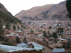 Huancavelica | |
 Flag  Coat of arms | |
 | |
| Country | |
| Region | Huancavelica |
| Province | Huancavelica |
| Capital | Huancavelica |
| Government | |
| • Mayor | Rómulo Cayllahua Paytán (2019–2022) |
| Area | |
• Total | 514.1 km2 (198.5 sq mi) |
| Elevation | 3,660 m (12,010 ft) |
| Population (2017) | |
• Total | 39,776 |
| • Density | 77/km2 (200/sq mi) |
| Time zone | UTC-5 (PET) |
| UBIGEO | 090101 |
Huancavelica District is one of nineteen districts of the province Huancavelica in Peru. [1]