Ahuaycha District

Last updated
Ahuaycha
Awaycha
Paisaje-Ahuaycha.jpg
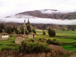
Landscape of Ahuaycha
Ahuaycha District
Country Flag of Peru.svg  Peru
Region Huancavelica
Province Tayacaja
FoundedDecember 14, 1954
Capital Ahuaycha
Government
   Mayor Raul Huaman Vasquez
Area
  Total
90.96 km2 (35.12 sq mi)
Elevation
3,280 m (10,760 ft)
Population
  Total
5,939
  Density65/km2 (170/sq mi)
Time zone UTC-5 (PET)
UBIGEO 090704

Ahuaycha District is one of sixteen districts of the province Tayacaja in Peru. [1]

Contents

Ethnic groups

The people in the district are mainly Indigenous citizens of Quechua descent. Quechua is the language which the majority of the population (54.30%) learnt to speak in childhood, 45.43% of the residents started speaking using the Spanish language (2007 Peru Census). [2]

Climate

Climate data for Pampas, Ahuaycha, elevation 3,250 m (10,660 ft), (1991–2020)
MonthJanFebMarAprMayJunJulAugSepOctNovDecYear
Mean daily maximum °C (°F)17.6
(63.7)
17.3
(63.1)
17.3
(63.1)
17.9
(64.2)
18.1
(64.6)
17.8
(64.0)
17.5
(63.5)
17.9
(64.2)
18.0
(64.4)
18.6
(65.5)
19.0
(66.2)
18.1
(64.6)
17.9
(64.3)
Mean daily minimum °C (°F)5.8
(42.4)
6.4
(43.5)
5.8
(42.4)
3.7
(38.7)
1.4
(34.5)
−0.3
(31.5)
−0.8
(30.6)
0.5
(32.9)
2.8
(37.0)
4.0
(39.2)
4.3
(39.7)
5.3
(41.5)
3.2
(37.8)
Average precipitation mm (inches)91.1
(3.59)
95.5
(3.76)
84.5
(3.33)
34.4
(1.35)
15.4
(0.61)
8.1
(0.32)
13.9
(0.55)
15.1
(0.59)
26.5
(1.04)
39.4
(1.55)
44.2
(1.74)
79.2
(3.12)
547.3
(21.55)
Source: National Meteorology and Hydrology Service of Peru [3]

See also

References

  1. (in Spanish) Instituto Nacional de Estadística e Informática. Banco de Información Distrital Archived April 23, 2008, at the Wayback Machine . Retrieved April 11, 2008.
  2. inei.gob.pe Archived 2013-01-27 at the Wayback Machine INEI, Peru, Censos Nacionales 2007, Frequencias: Preguntas de Población: Idioma o lengua con el que aprendió hablar (in Spanish)
  3. "Normales Climaticás Estándares y Medias 1991-2020". National Meteorology and Hydrology Service of Peru. Archived from the original on 21 August 2023. Retrieved 6 November 2023.

12°24′27″S74°53′29″W / 12.4074°S 74.8914°W / -12.4074; -74.8914