| Kachi Mayu | |
|---|---|
| Etymology | Quechua |
| Location | |
| Country | Bolivia |
| Region | Chuquisaca Department |
| Physical characteristics | |
| Mouth | |
• location | Chuquisaca Department (Yotalla Municipality) / Potosí Department |
• coordinates | 19°18′48″S65°15′59″W / 19.31333°S 65.26639°W |
Kachi Mayu (Quechua kachi salt, mayu river, [1] "salt river", also spelled Cachi) is a Bolivian river in the Chuquisaca Department, Oropeza Province, in the Sucre and Yotalla Municipalities. [2] It is a left tributary of the Pillku Mayu, not to be confused with the Kachi Mayu in the Oruro Department which is the headwater of the Pillku Mayu. The confluence is on the border of the Yotalla Municipality and the Potosí Department, west of the village of Tasapampa. [3]
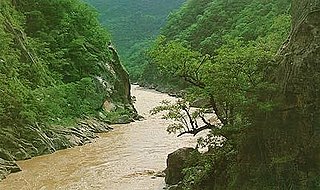
Pilcomayo is a river in central South America. At 1,100 kilometres (680 mi) long, it is the longest western tributary of the Paraguay River. Its drainage basin is 270,000 square kilometres (100,000 sq mi) in area, and its mean discharge is 200 cubic metres per second (7,100 cu ft/s).
Kachi Mayu is a Bolivian river east of Poopó Lake in the Oruro Department, Challapata Province, Challapata Municipality. Its source, the Jach'a Juqhu River, is considered the origin of the Pillku Mayu.
Ch'aki Mayu, also Kachi Mayu, is a Bolivian river in the Potosí Department. It flows towards the Pillku Mayu.
Jatun Mayu which downstream successively is named Challajtiri Mayu, Rosario, Agua Castilla, Jatun Mayu again and Qaysa is a Bolivian river in the provinces of Antonio Quijarro, José María Linares and Tomás Frías of the Potosí Department. It belongs to the Pillku Mayu river basin.
T'uruchipa is a Bolivian river in the Potosí Department, José María Linares Province, Ckochas Municipality, T'uruchipa Canton. It is a right tributary to the Pillku Mayu.
Chiñi Mayu is a Bolivian river in the Chuquisaca Department, Nor Cinti Province, San Lucas Municipality and Camargo Municipality. It belongs to the Pillku Mayu river basin.
Urqu Qucha is a lake in the Andes of Bolivia. It is located in the Potosí Department, Cornelio Saavedra Province, Tacobamba Municipality, at the border with the Tomás Frías Province, Potosí Municipality. Urqu Qucha lies south-west of the mountain Titi Pinkillu and north of the Challwiri River, an affluent of the Pillku Mayu.
Jatun Q'asa is a 4,590-metre-high (15,059 ft) mountain in the Bolivian Andes. It is situated in the Potosí Department, Tomás Frías Province, Potosí Municipality. Some of the nearest settlements are Umallani and Salla K'uchu. Jatun Q'asa lies east Wayra Wasi, between the Ch'aki Mayu in the west and the Challwiri River (Challviri) in the east. Both rivers flow to the north as right tributaries of the Pillku Mayu.
Titi Pinkillu is a 4,529-metre-high (14,859 ft) mountain in the Bolivian Andes. It is situated in the Potosí Department, Cornelio Saavedra Province, Tacobamba Municipality, near the border with the Tomás Frías Province, Potosí Municipality. Titi Pinkillu lies north-east of the lake Urqu Qucha. This is also where the Challwiri River, an affluent of the Pillku Mayu, originates.
Puka Qallpa is a 3,886-metre-high (12,749 ft) mountain in the Bolivian Andes. It is located in the Cochabamba Department, Mizque Province, Alalay Municipality. It lies in the northwest of Kachi Q'asa and northeast of Inka Pirqa. The Puka Urqu Mayu flows along its western slope. Its waters flow to the Jatun Mayu in the south.
Misk'a Urqu is a mountain in the Bolivian Andes which reaches a height of approximately 3,260 m (10,700 ft). It is located in the Chuquisaca Department, Oropeza Province, Yotala Municipality. Misk'a Urqu lies southeast of Chullpa Urqu. The Misk'a River originates east of the mountain. Its waters flow to the Pillku Mayu.
P'aqla Urqu is a 3,038-metre-high (9,967 ft) mountain in the Bolivian Andes. It is located in the Chuquisaca Department, Oropeza Province, Yotala Municipality. P'aqla Urqu lies at the Panti Mayu which is a left tributary of the Pillku Mayu.
Mulli Urqu is a 2,906-metre-high (9,534 ft) mountain in the Bolivian Andes. It is located in the Chuquisaca Department, Oropeza Province, Yotala Municipality. Mulli Urqu lies west of the Kachi Mayu which is a left tributary of the Pillku Mayu.
Jatun Mayu is a Bolivian river in the Chuquisaca Department, Jaime Zudáñez Province, Icla Municipality. It is a left affluent of the Icla River. It belongs to the watershed of the Pillku Mayu.
Q'illu Qisqa is a mountain in the Bolivian Andes which reaches a height of approximately 2,660 m (8,730 ft). It is located in the Chuquisaca Department, Jaime Zudáñez Province, Icla Municipality. Q'illu Qisqa lies at the Icla River which is a left tributary of the Pillku Mayu.
Uritu Mayu is a Bolivian river in the Chuquisaca Department, Jaime Zudáñez Province, Icla Municipality. It is a left affluent of the Pillku Mayu.
Wallqayuq Urqu is a 4,124-metre-high (13,530 ft) mountain in the Bolivian Andes. It is located in the Chuquisaca Department, on the border of the Azurduy Province, Tarvita Municipality, and the Jaime Zudáñez Province, Icla Municipality. Wallqayuq Kimray lies west of Wisk'achani and northeast of Wanaku Kimray. The Phaqcha Mayu originates south of the mountain. It flows to the south as an affluent of the Qucha Mayu which downstream is named San José. It is a left tributary of the Pillku Mayu.
Chhichayuq is a 3,846-metre-high (12,618 ft) mountain in the Bolivian Andes. It is located in the Chuquisaca Department, Azurduy Province, Tarvita Municipality. Chhichayuq lies northwest of Wisk'achani and northeast of Wallqayuq Urqu. The Qucha Mayu, which downstream is named San José originates northwest of the mountain. It is a left tributary of the Pillku Mayu.
Inka Wasi is a 3,146-metre-high (10,322 ft) mountain in the Bolivian Andes. It is located in the Chuquisaca Department, Azurduy Province, Tarvita Municipality. Inka Wasi lies southwest of Muyu Urqu and north of Pukara. The Laqha Mayu originates north of the mountain. Its waters flow to the Pillku Mayu.
T'uqu Chaka is a 4,164-metre-high (13,661 ft) mountain in the Andes of Bolivia. It is located in the Potosí Department, Cornelio Saavedra Province, Tacobamba Municipality. T'uqu Chaka lies between Qiñwa Qullu in the northeast and Wañuma Q'asa in the southwest. It is west of the Ch'aki Mayu. Its waters flow to the Pillku Mayu.
{{cite book}}: CS1 maint: location missing publisher (link)