
Fieldon is a village in Jersey County, Illinois, United States. As of the 2020 census, the village had a total population of 176. The village's current mayor is Julia Dixon.

Harveysburg is a village in Massie Township, Warren County, Ohio, United States. The population was 554 at the 2020 census. It is best known as the home of the Ohio Renaissance Festival.

The Squamish-Lillooet Regional District is a quasi-municipal administrative area in British Columbia, Canada. It stretches from Britannia Beach in the south to Pavilion in the north. Lillooet, Pemberton, Whistler and Squamish are the four municipalities in the regional district. Its administrative offices are in the Village of Pemberton, although the district municipalities of Squamish and Whistler are larger population centres. The district covers 16,353.68 km² of land area.

The Thompson–Nicola Regional District is a regional district in the Canadian province of British Columbia. The Canada 2021 Census population was 143,680 and the area covers 44,449.49 square kilometres. The administrative offices are in the main population centre of Kamloops, which accounts for 78 percent of the regional district's population. The only other city is Merritt; other municipally-incorporated communities include the District Municipalities of Logan Lake, Barriere and Clearwater and the Villages of Chase, Ashcroft, Cache Creek, Clinton and Lytton, and also the Mountain Resort Municipality of Sun Peaks.

Khagaria district is an administrative district in Mithila region in the state of Bihar in India. The district headquarters are located at Khagaria. Earlier it was a part of Munger District as a sub-division that was created in 1943–44. It was upgraded to the status of a district on 10 May 1981. Khagaria district is a part of Munger Division.

Simdega district is one of the 24 districts of Jharkhand state, India, and Simdega town is the administrative headquarters of this district. As of 2011, this district is the least densely populated district and the third least populous district of Jharkhand after Lohardaga and Khunti districts. Simdega District was carved out from erstwhile Gumla district on 30 April 2001. It is currently a part of the Red Corridor.

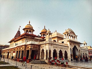
Bharatpur District is a district in Rajasthan state in western India. The city of Bharatpur is the District Headquarters, Division Headquarters and Headquarters of Bharatpur Police Range of Rajasthan Police. Bharatpur District is a part of National Capital Region of India Delhi.
Michigan's 1st congressional district is a United States congressional district that fully contains the 15 counties of the Upper Peninsula of Michigan and 20 counties of Northern Michigan in the Lower Peninsula. The district is currently represented by Republican Jack Bergman.
Karauli District is a district of the state of Rajasthan in western India. It is located in the Braj Bhoomi region. The town of Karauli serves as the administrative headquarters of the district. Karauli district also comes under the Bharatpur Divisional Commissionerate.
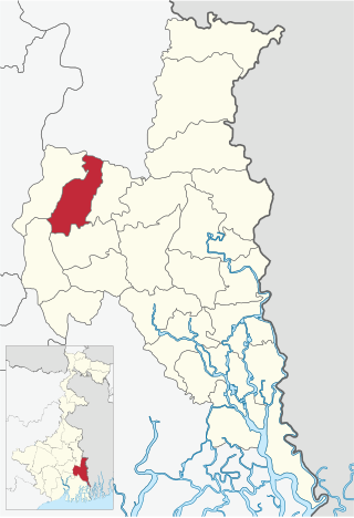
Amdanga is a community development block that forms an administrative division in North 24 Parganas district in the Indian state of West Bengal.
Deganga is a community development block that forms an administrative division in North 24 Parganas district in the Indian state of West Bengal.

Sandeshkhali I is a community development block that forms an administrative division in Basirhat subdivision of North 24 Parganas district in the Indian state of West Bengal.
Nata is a village in Central District of Botswana. It is located in the northern part of the district, and is served by Nata Airport. The population was 6,802 at the 2011 census. The village of Nata lies along the Nata River, which carries its rainy season flow to the Makgadikgadi Pans, a seasonal hypersaline lake.
Bokaa is a village in Kgatleng District of Botswana. The village is located around 20 km south-west of Mochudi and the population was 5,765 in 2011 census. The village is just north of the Bokaa Dam.
Mmopane is a village in the Kweneng District of Botswana. The village is located around 15 km from Gaborone, the capital of Botswana. The population was 3,512 in 2001 census and 14,655 at the 2011 census. It's now part of Gaborone agglomeration home to 421,907 inhabitants at the 2011 census.
Kopong is a small village in Kweneng District of Botswana. It is located around 25 km north of Gaborone, the capital of Botswana. The population was 5,571 in 2001 census and 9,520 at the 2011 census, making it the sixth largest settlement in Kweneng. It is now becoming a suburb of Gaborone agglomeration home to 421,907 inhabitants at the 2011 census.
Donja Gorevnica is a village in the municipality of Čačak, Serbia. According to the 2011 census, the village has a population of 877 people.
Arbanaška is a village in the municipality of Trebinje, Republika Srpska, Bosnia and Herzegovina.
Zovi Do is a village in the municipality of Nevesinje, Republika Srpska, Bosnia and Herzegovina.
Mokhdan is a village in Howmeh Rural District, in the Central District of Deyr County, Bushehr Province, Iran. At the 2006 census, its population was 37, in 9 families.
