
Rayalaseema is a geographic region in the Indian state of Andhra Pradesh. It comprises four southern districts of the state namely, Anantapur, Chittoor, Kadapa and Kurnool. As of 2011 census of India, the region with four districts had a population of 15,184,908 and covers an area of 67,526 km2 (26,072 sq mi).

Kalyandurg is a town in Anantapur district of the Indian state of Andhra Pradesh. It is the headquarters for Kalyandurg mandal and Kalyandurg revenue division. The discovery of diamond-bearing Kimberlites in Kalyandurg area, is one of the clusters that has been discovered.

Vizianagaram district is one of the nine districts in the Coastal Andhra region of the Indian state of Andhra Pradesh with its headquarters located at Vizianagaram. The district is bounded on the east by the district of Srikakulam, southwest by the City of Bheemunipatnam, southeast by the Bay of Bengal, and northwest by the state of Odisha. It was formed on 1 June 1979, with some parts carved from the neighbouring districts of Srikakulam and Visakhapatnam. The district is named after the princely state of Vizianagaram. It is the least populous district in Andhra Pradesh.
Khammam district is a district in the eastern region of the Indian state of Telangana. The city of Khammam is the district headquarters. The district shares boundaries with Suryapet, Mahabubabad, Bhadradri districts and with Andhra pradesh state.

Anantapur district is one of the four districts in the Rayalaseema region of the Indian state of Andhra Pradesh. The district headquarters is located at Anantapur city. It is one of the driest places in South India. As of 2011 census of India, it is the largest district in the state by area and with a population of 4,083,315, it is the eighth most populous district.

Kadapa district is one of the thirteen districts in the Indian state of Andhra Pradesh. It is also one of the four districts in the Rayalaseema region of the state. Kadapa is the seat of administration for the district. The district was renamed as YSR District in honour of Y. S. Rajasekhara Reddy, commemorating former chief minister of united Andhra Pradesh.

Srikakulam district is one of the nine districts in the Coastal Andhra region of the Indian state of Andhra Pradesh, with its headquarters located at Srikakulam. It is one of the nine coastal districts, located in the extreme northeastern direction of the state. It was formerly known as Chicacole.
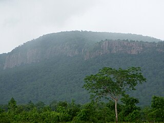
Kadiri is a major city in the Anantapur district of the Indian state of Andhra Pradesh. It is a 'Special Grade' Municipal City Council and headquarters of Kadiri Mandal and Kadiri Revenue Division. Kadiri Taluka ('Tehsil') was the largest taluk in the state of Andhra Pradesh when there was taluka system in Andhra Pradesh Kadiri is known for its jasmine and saffron flowers. Kadiri saffron is widely sold in Andhra and Karnataka. The Sri Lakshmi Narasimhaswamy Temple is reminiscent of Kadiri to the people of Karnataka, Telangana And Tamil Nadu. The name of Kadiri has also some interesting past. The habitation was initially named as Khadripuram as ‘khadara’ plants were largely found in the surrounding forests and Khadri has later transformed as Kadiri.

Pulivendula (2008) is a small town in YSR Kadapa district, a district of the Indian state of Andhra Pradesh. According to ancient folklore, its name is derived from "Puli Mandala", which was originally a forested area populated by tigers. It is located in Pulivendula mandal of the Jammalamadugu revenue division. Pulivendula is nearly 40 km away from Major City Kadiri.
Gandlapenta is a village in Anantapur district of the Indian state of Andhra Pradesh. It is the headquarters of Gandlapenta mandal in Kadiri revenue division.
Obuladevaracheruvu is a small town in Anantapur district of the Indian state of Andhra Pradesh. It is the headquarters of Obuladevaracheruvu mandal in Kadiri revenue division.
Nallacheruvu is a village in Anantapur district of the Indian state of Andhra Pradesh. It is the headquarters of Nallacheruvu mandal in Kadiri revenue division.
Talamarla is a village in Anantapur district of the Indian state of Andhra Pradesh. It is located in Kothacheruvu mandal of Kadiri Revenue Division.
A tehsil is a local unit of administrative division in some countries of the South Asia that is usually translated to "township". It is a subdistrict of the area within a district including the designated city, town, hamlet, or other populated place that serves as its administrative centre, with possible additional towns, and usually a number of villages. The terms in India have replaced earlier geographical terms, such as pargana (pergunnah) and thana.
Tanakal is a village in Anantapur district of the Indian state of Andhra Pradesh. It is the headquarters of Tanakal mandal in Kadiri revenue division.

Mangalagiri mandal is one of the 57 mandals in Guntur district of the Indian state of Andhra Pradesh. It is under the administration of Guntur revenue division and the headquarters are located at Mangalagiri town part of Mangalagiri Tadepalle Municipal Corporation. The mandal is bounded by Thullur, Tadepalle, Tadikonda, Pedakakani and Duggirala mandals and a portion of the mandal lies on the banks of Krishna River.
Tenali mandal is one of the 57 mandals in Guntur district of the Indian state of Andhra Pradesh. It is under the administration of Tenali revenue division, headquartered at Tenali. The mandal is located in Velanadu region, bounded by Pedakakani, Duggirala, Kollipara, Vemuru, Amruthalur, Tsundur and Chebrole mandals.

Repalle mandal is one of the 57 mandals in Guntur district of the state of Andhra Pradesh, India. It is under the administration of Tenali Revenue Division and the headquarters are located at Repalle. The mandal is situated on the banks of Krishna River of Velanadu region and is bounded by Bhattiprolu, Nagaram and Nizampatnam mandals.

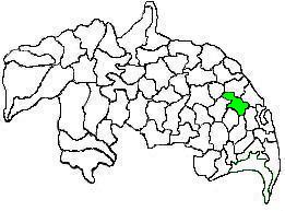
Kadiri revenue division is an administrative division in the Anantapur district of the Indian state of Andhra Pradesh. It is one of the 5 revenue divisions in the district with 12 mandals under its administration. The divisional headquarters is located at Kadiri.