Nalgonda is a city and municipality in the Indian state of Telangana. It is the headquarters of the Nalgonda district, as well as the headquarters of the Nalgonda mandal in the Nalgonda revenue division. It is located about 90 kilometres (56 mi) from the state capital Hyderabad.

Supaul district is one of the thirty-eight districts of Bihar, India. The town Supaul is the district's administrative headquarters. The district, which was split from the former Saharsa district on 14 March 1991, occupies 2,410 km2 (931 sq mi).

Dumka district is one of the twenty-four districts of Jharkhand state in eastern India. Dumka is the administrative headquarters of this district. This district covers an area of 3716.02 km2. This district has a population of 1,321,442.

Sawai Madhopur district is a district of Rajasthan state in north-west India. Sawai Madhopur is the chief town and district headquarters. Sawai Madhopur district comes under Bharatpur division.

Vizianagaram district is one of the six districts in the Uttarandhra region of the Indian state of Andhra Pradesh with its headquarters located at Vizianagaram. The district was once the part of ancient Kalinga.Saripilli Dibbilingeswara temple, Jayathi Mallikarjuna Temple are the finest examples of ancient Eastern Ganga Dynasty built monuments in the district. The district is bounded on the east by the district of Srikakulam, north by Parvathipuram Manyam south by Visakhapatnam, Anakapalli, southeast by the Bay of Bengal, and west by Alluri Sitharama Raju district. It was formed on 1 June 1979, with some parts carved from the neighbouring districts of Srikakulam and Visakhapatnam. The district is named after the princely state of Vizianagaram. In 2011, it was the least populous district in Andhra Pradesh.

Wardha District is in the state of Maharashtra in western India. This district is a part of Nagpur Division. The city of Wardha is the administrative headquarter of the district. Hinganghat, Pulgaon, Arvi and Wardha are the major cities in the District. The District had a population of 1,300,774, of which 26.28% were urban as of 2011.

Dharmasagar is a Town and a mandal in Hanamkonda district in Telangana, India. Dharmasagar is well connected with towns like Kazipet, and Hanamakonda by road. It is 14.4 km far from its District Main Town Warangal and 122 km far from its State Capital Hyderabad.

Anantapur district, officially Anantapuramu district, is one of the eight districts in the Rayalaseema region of the Indian state of Andhra Pradesh. The district headquarters is located in Anantapur city. It is one of the driest places in South India. In the year 2022, as part of re-organisation of districts, Sri Sathya Sai district was carved out.

Nizamabad district is a district located in the north-western region of the Indian state of Telangana. The city of Nizamabad is the district headquarters. The district share boundaries with Jagtial, Sircilla, Nirmal, Kamareddy districts and with Nanded district of the state boundary of Maharashtra.

Srikakulam district is one of the twenty-six districts of the Indian state of Andhra Pradesh, located in the Uttarandhra region of the state, with its headquarters located at Srikakulam. It is one of the six districts, located in the extreme northeastern direction of the state. It was formerly known as Chicacole, and was under Ganjam district till 1936 April 1, then merged under Vizagapatam district. Srikakulam district forms the core area of Kalinga where most of its historical capitals like Kalinganagari, pithunda, Dantapuram are located.

Bighapur is a town and nagar panchayat in Unnao district of Uttar Pradesh, India. First officially classified as a town for the 1981 census, it now serves as a tehsil headquarters(established in Patan). Important items manufactured here include clay pots, leather products, and wooden furniture. As of 2011, the population of Bighapur is 6,501, in 1,201 households.

Fatehpur Chaurasi is a town and a nagar panchayat in Unnao district in the state of Uttar Pradesh, India. First officially classified as a town for the 1981 census, Fatehpur Chaurasi is located on the north bank of the Kalyani river, a bit to the south of the main road from Unnao to Bangarmau. Local industries include the production of furniture, boxes, almirahs, shoes, and slippers. As of 2011, the town's population is 6,715, in 1,158 households.

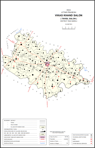
Salon is a town and nagar panchayat in Raebareli district in the Indian state of Uttar Pradesh. It serves as the headquarters of a tehsil as well as a community development block. Originally it was also the headquarters of the entire district, but they were moved after the Indian Rebellion of 1857. It is located a bit to the south of the Sai river, at the junction of the Raebareli-Pratapgarh and Jais-Khaga roads. Other roads lead to Dalmau, Manikpur, and Kunda. To the east is a large jhil.
Namkhana is a community development block that forms an administrative division in Kakdwip subdivision of South 24 Parganas district in West Bengal state of India.
Kurli is a village which is to the south of Pulivendula in Talupula mandal of Anantapur district in the state of Andhra Pradesh in India.
Magrahat II is a community development block that forms an administrative division in Diamond Harbour subdivision of South 24 Parganas district in the Indian State of West Bengal.

Narasapuram Mandal is one of the 19 mandals in the West Godavari district of the Indian state of Andhra Pradesh. Its headquarters are in Narasapuram, a town in the mandal. The mandal is bordered by the Godavari River to the north, the Bay of Bengal to the east, the Mogalthur mandal to the south, and the Palacole mandal to the west.

Medchal−Malkajgiri district is a district in the Indian state of Telangana. Shamirpet is the headquarter of the district. It is the second most populous district with a population of 25 lakh and also 91.40% urbanized district in the state of Telangana, standing next only to Hyderabad district which has a population of 40 lakhs. The district shares boundaries with Hyderabad, Medak, Sangareddy, Y. Bhuvanagiri, Siddipet and Rangareddy districts.The most part of the district consist of Hyderabad City (GHMC)
Unguturu mandal is one of 28 mandals in the Eluru district of the Indian state of Andhra Pradesh. The headquarters are located at Unguturu. The mandal is bordered by Tadepalligudem mandal and Pentapadu mandal to the north, Nallajerla mandal to the west, Nidamarru mandal to the east, and by Dwaraka Tirumala mandal and Bhimadole mandal to the south
Challapalli mandal is one of the 25 mandals in the Krishna district of the Indian state of Andhra Pradesh. The headquarters of this mandal are located in Challapalli.


