
Iguazú Falls or Iguaçu Falls are waterfalls of the Iguazu River on the border of the Argentine province of Misiones and the Brazilian state of Paraná. Together, they make up the largest waterfall system in the world. The falls divide the river into the upper and lower Iguazu. The Iguazu River rises near the heart of the city of Curitiba. For most of its course, the river flows through Brazil; however, most of the falls are on the Argentine side. Below its confluence with the San Antonio River, the Iguazu River forms the border between Argentina and Brazil.

Yoho National Park is a national park of Canada. It is located within the Rocky Mountains along the western slope of the Continental Divide of the Americas in southeastern British Columbia, bordered by Kootenay National Park to the south and Banff National Park to the east in Alberta. The word Yoho is a Cree expression of amazement or awe, and it is an apt description for the park's spectacular landscape of massive ice fields and mountain peaks, which rank among the highest in the Canadian Rockies.
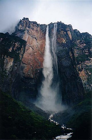
Angel Falls is a waterfall in Venezuela. It is the world's tallest uninterrupted waterfall, with a height of 979 metres (3,212 ft), and a plunge of 807 m (2,648 ft). The waterfall drops over the edge of the Auyán-tepui mountain in the Canaima National Park, a UNESCO World Heritage Site in the Gran Sabana region of Bolívar State. The height figure, 979 m (3,212 ft), mostly consists of the main plunge but also includes about 400 metres (1,300 ft) of sloped cascade and rapids below the drop and a 30-metre-high (100 ft) plunge downstream of the talus rapids.

The Montmorency Falls is a large waterfall on the Montmorency River in Quebec, Canada.

Rjukan is a town in Tinn Municipality in Telemark county, Norway. The town is also the administrative centre of Tinn Municipality. The town is located in the Vestfjorddalen valley, between the lakes Møsvatn and Tinnsjå. The municipal council of Tinn declared town status for Rjukan in 1996. The town is located about 10 kilometres (6.2 mi) to the west of the village of Miland and about 20 kilometres (12 mi) to the northwest of the village of Tuddal.

The Rideau Falls are two 11-metre waterfalls located in Ottawa, Ontario, Canada, where the Rideau River empties into the Ottawa River. The falls are divided by Green Island, with Ottawa's Old City Hall just to the south. To the west of the falls is the headquarters of the National Research Council while to the east are the Canada and the World Pavilion and the French Embassy. Samuel de Champlain described the falls as "...a marvelous fall...it descends a height of twenty or twenty-five fathoms with such impetuosity that it makes an arch nearly four hundred paces broad." The falls were named by the early French for their resemblance to a curtain, or rideau in French. The Rideau River was later named after the falls. The Rideau Canal was constructed to bypass these falls and the Hog's Back Falls.

The Geiranger Fjord is a fjord in the Sunnmøre region of Møre og Romsdal county, Norway. It is located entirely in the Stranda Municipality. It is a 15-kilometre-long branch off the Sunnylvsfjorden, which is a branch off the Storfjorden. The small village of Geiranger is located at the end of the fjord where the Geirangelva river empties into it.

Boali is a town located in the Central African Republic prefecture of Ombella-M'Poko.

Rusumo Falls is a waterfall located on the Kagera river on the border between Rwanda and Tanzania, part of the most distant headwaters of the river Nile. The falls are approximately 15 m (49 ft) high and 40 m (130 ft) wide and have formed on Precambrian schists and quartz–phyllites.

The Purling Brook Falls or sometimes incorrectly Purlingbrook Falls, a horsetail waterfall on the Purling Brook, is located in the UNESCO World Heritage–listed Gondwana Rainforests in the South East region of Queensland, Australia.

Tip Toe Falls, is a 6-foot (1.8 m) tall waterfall on Fall Creek in the Portola Redwoods State Park, California. There is also an 8-foot (2.4 m) upper falls, a few hundred feet upstream, which is much lesser known.

The Tully Falls, a horsetail chute waterfall on the Tully River, is located in the UNESCO World Heritage–listed Wet Tropics in the Far North region of Queensland, Australia. It formed the eastern boundary of the Dyirbal.

Anticosti National Park is a provincial park of Quebec, located in the Gulf of St. Lawrence. It consists of 3 non-contiguous areas totalling 572 square kilometres (221 sq mi) of land in the centre of Anticosti Island. Portions of the park are within Anticosti World Heritage site.

Havasu Creek is a stream in the U.S. state of Arizona. It is a tributary to the Colorado River, which it joins in the Grand Canyon. It primarily runs through the Havasupai Indian Reservation. It is sometimes called Cataract Creek, and should not be confused with Cataract Canyon, Utah.
The Park of the Kabir Kouba Cliff and Waterfall is a public park in Quebec City, Quebec crossed by the Saint-Charles River. The rapids and falls of this section of the river are called Kabir Kouba the «river of a thousand bends» in the Montagnais language. An interpretive center and trails permit the observation of the Kabir Kouba waterfall that has a height of 28 metres. The trails also provide a view of the canyon which at its highest point measures 42 metres as well as a rich variety of flora, fauna and fossils dating over 455 million years old. The interpretive center also offers services such as Kabir Kouba by Lantern, A Day at Loretteville package as well as guided visits of the falls. A song by the singer Claire Pelletier, Kabir Kouba, evoques the many Huron legends that honour the river and the waterfall.

The Félou Falls are located on the Sénégal River 15 kilometres (9.3 mi) upstream of Kayes in western Mali. The river tumbles 13 metres (43 ft) down an irregular series of rocky steps. The waterfalls mark the furthest point from the mouth of the river that can be reached by boat. In 2009 work started on the construction of the Félou Hydroelectric Plant, a 62.3 megawatts (83,500 hp) run-of-the-river hydroelectric plant at the falls replacing a small 600 kW plant dating from the 1920s.

Tourism in Venezuela has been developed considerably for decades, particularly because of its geographical position, the variety of landscapes, the richness of plants and wildlife, the artistic expressions and the privileged tropical climate of the country, which affords each region throughout the year. Since 2013, the country is having a very severe economic and political crisis affecting tourism all over the country.


