
The Gambia, officially the Republic of the Gambia, is a country in West Africa. It is the smallest country within mainland Africa and is surrounded by Senegal, except for its western coast on the Atlantic Ocean. The Gambia is situated on both sides of the lower reaches of the Gambia River, the nation's namesake, which flows through the centre of the Gambia and empties into the Atlantic Ocean. It has an area of 10,689 square kilometres (4,127 sq mi) with a population of 1,857,181 as of the April 2013 census. Banjul is the Gambian capital and the country's largest metropolitan area. The largest cities are Serekunda and Brikama.
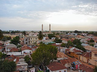
Banjul, officially the City of Banjul, is the capital and fourth largest city of The Gambia. It is the centre of the eponymous administrative division which is home to an estimated 400,000 residents, making it The Gambia's largest and most densely populated metropolitan area. Banjul is on St Mary's Island, where the Gambia River enters the Atlantic Ocean. The population of the city proper is 31,301, with the Greater Banjul Area, which includes the City of Banjul and the Kanifing Municipal Council, at a population of 413,397. The island is connected to the mainland to the west and the rest of Greater Banjul Area via bridges. There are also ferries linking Banjul to the mainland at the other side of the river.
Telecommunications in the Gambia includes radio, television, fixed and mobile telephones, and the Internet.

The demographic characteristics of the population of the Gambia are known through national censuses, conducted in ten-year intervals and analyzed by The Gambian Bureau of Statistics (GBOS) since 1963. The latest census was conducted in 2013. The population of The Gambia at the 2013 census was 1.8 million. The population density is 176.1 per square kilometer, and the overall life expectancy in The Gambia is 64.1 years. Since the first census of 1963, the population of The Gambia has increased every ten years by an average of 43.2 percent. Since 1950s, the birth rate has constantly exceeded the death rate; the natural growth rate is positive. The Gambia is in the second stage of demographic transition. In terms of age structure, The Gambia is dominated by 15- to 64-year-old segment (57.6%). The median age of the population is 19.9 years, and the gender ratio of the total population is 0.98 males per female.

Basse Santa Su, usually known as Basse, is a town in the Gambia, lying on the south bank of the River Gambia. The easternmost major town in the nation, it is the capital of the Upper River Region and is known for its important market. As of 2009 it has an estimated population of 18,414. The history of the town dates back to the founding of Kabakama, now a neighborhood, in the mid 13th century by the Mandinka army of Tiramakhan Traore, who was ultimately buried there, expanding the Mali Empire west.

The Wolof people are a West African ethnic group found in northwestern Senegal, the Gambia, and southwestern coastal Mauritania. In Senegal, the Wolof are the largest ethnic group (~43.3%), while elsewhere they are a minority. They refer to themselves as Wolof and speak the Wolof language, in the West Atlantic branch of the Niger–Congo family of languages.

Lower River Division is one of the five administrative divisions of the Gambia. Its capital is Mansa Konko. The city and area council elections were held during April 2002, when Wally S.M. Sanneh, an APRC candidate became the Mayor, winning unopposed. The council was led by Alliance for Patriotic Reorientation and Construction (APRC), which won all the 12 seats.

Central River was the largest of the five administrative divisions of the Gambia. Its capital was Janjanbureh, on MacCarthy Island. The largest settlement was Bansang, with an estimated population in 2008 of 8,381.

North Bank was one of the five administrative divisions of the Gambia. Its capital was Kerewan. It was subsequently reorganised as the Kerewan Local Government Area (LGA), without any change in the area covered.

Upper River was one of the five Divisions of the Gambia. Its capital was Basse Santa Su. It was subsequently reorganised as the Basse Local Government Area, without any change in the area covered.

West Coast Region, originally the Western Division, also known as Foni or Fonyi, was one of the five administrative divisions of the Gambia. Its capital was Brikama. It was subsequently reorganised as the Brikama Local Government Area (LGA), without any change in the area covered.

Kuntaur is a town located in the Central River Division of the Gambia.

The Jola or Diola are an ethnic group found in Senegal, the Gambia, and Guinea-Bissau. Most Jola live in small villages scattered throughout Senegal, especially in the Lower Casamance region. The main dialect of the Jola language, Fogni, is one of the six national languages of Senegal.
The Gambia is subdivided into 43 districts. They are listed below, by Local Government Area, each with its population at the 15 April 2013 Census.

The Gambia is divided into five administrative Regions and one City. The divisions of the Gambia are created by the Independent Electoral Commission in accordance to Article 192 of the National Constitution.
The following outline is provided as an overview of and topical guide to the Gambia:
The tourism industry today in the Gambia started when a party of 300 Swedish tourists arrived in 1965. That pioneering trip was organised by a Swede named Bertil Harding together with the tour operators Vingresor. It was seen as an ideal place to escape the harsh winter months of Scandinavia where Europeans would enjoy not only sun, sand and beaches but also experience the excitement of a real African holiday. It also offered a new opening for an affordable holiday to increasing numbers of traveling Europeans.
Karantaba Tenda is a small town in north-eastern Gambia. It is located in Sami District in the Central River Division. As of 2009, it has an estimated population of 1922.
The bushbuck is the nominate taxon of the bushbuck. It is a small to medium-sized antelope widespread in Africa. The Cape bushbuck is a southern and eastern subspecies which is recognised by some authors, which found evidence to consider the northern and southern populations to belong to a different subspecies in 2007.
The Gambian Creole people, or Krio or Aku, are a minority ethnic group of Gambia with connections to and some roots from the Sierra Leone Creole people. In Gambia the Aku account for about 2% of the population. Some estimates put the figure higher. However, according to the 2013 Gambian Census, the Aku make up 0.5% of the population or around 8,477 people.
