
Great Barrier Island lies in the outer Hauraki Gulf, New Zealand, 100 kilometres (62 mi) north-east of central Auckland. With an area of 285 square kilometres (110 sq mi) it is the sixth-largest island of New Zealand and fourth-largest in the main chain. Its highest point, Mount Hobson, is 627 metres (2,057 ft) above sea level. The local authority is the Auckland Council.

Waiheke Island is the second-largest island in the Hauraki Gulf of New Zealand. Its ferry terminal in Matiatia Bay at the western end is 21.5 km (13.4 mi) from the central-city terminal in Auckland.
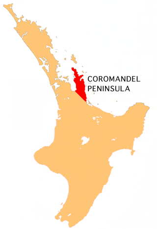
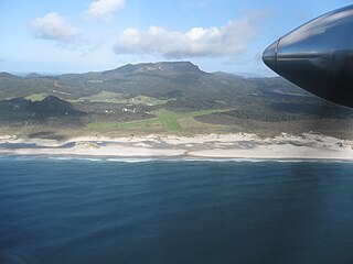
The Coromandel Peninsula on the North Island of New Zealand extends 85 kilometres (53 mi) north from the western end of the Bay of Plenty, forming a natural barrier protecting the Hauraki Gulf and the Firth of Thames in the west from the Pacific Ocean to the east. It is 40 kilometres (25 mi) wide at its broadest point. Almost its entire population lives on the narrow coastal strips fronting the Hauraki Gulf and the Bay of Plenty. In clear weather the peninsula is clearly visible from Auckland, the country's biggest city, which lies on the far shore of the Hauraki Gulf, 55 kilometres (34 mi) to the west. The peninsula is part of the Thames-Coromandel District and the Waikato Region.

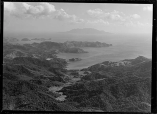
Cape Colville is the northernmost point of the Coromandel Peninsula in New Zealand's North Island. It lies 85 kilometres north of Thames, and 70 kilometres northeast of the city of Auckland, on the other side of the Hauraki Gulf. The small settlements of Port Jackson and Fletcher Bay lie immediately to the west and east respectively of the cape.

Little Barrier Island, or Hauturu in Māori, lies off the northeastern coast of New Zealand's North Island. Located 80 kilometres (50 mi) to the north of Auckland, the island is separated from the mainland to the west by Jellicoe Channel, and from the larger Great Barrier Island to the east by Cradock Channel. The two aptly named islands shelter the Hauraki Gulf from many of the storms of the Pacific Ocean.
Pakatoa Island, previously known as Bell's Island is one of many islands in the Hauraki Gulf of New Zealand, covering 24 hectares. Purchased in the early 1900s by the Salvation Army it was used as an alcohol treatment centre for men for two years, and later women when a larger facility was constructed on Rotoroa Island.
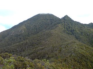
Mount Hobson is the highest mountain on Great Barrier Island, New Zealand. Located in the centre of the island, it rises 627 m (2,057 ft) above sea level.
Port Fitzroy is a harbour and coastal community on Great Barrier Island in New Zealand's Hauraki Gulf.
The Mokohinau Islands (Pokohinau), sometimes spelt Mokohīnau Islands are a small group of islands that lie off the northeast coast of New Zealand's North Island. The islands are 100 km (62 mi) northeast of Auckland, 21 km (13 mi) northwest of Great Barrier Island and approximately 52 km (32 mi) east of Bream Head. The main islands of the group include Fanal Island (Motukino), Burgess Island (Pokohinu), Flax Island (Hokoromea), and Atihau Island. Smaller islands include Bird Rock. Most of them are managed by the Department of Conservation as nature reserves and wildlife sanctuaries. Landing is not allowed without a permit, with the exception of Burgess Island, much of which is managed as a scenic reserve by the Department of Conservation. The remainder of Burgess Island is Crown Land and is administered by the Ministry of Transport. The total land area of the Mokohinau Islands is 160 ha (400 acres).

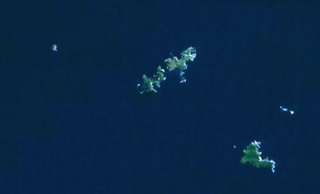
Tarahiki Island, also known as Shag Island, is a 6 ha island in the Hauraki Gulf of New Zealand. Its highest point is 68 m (223 ft) ASL and it lies 15.6 km (9.7 mi) from the mainland and about 3 km (1.9 mi) east of Waiheke Island. It is well known for its breeding colony of up to 700 spotted shags.

Harataonga Bay is a coastal feature and area on the northeast coast of Great Barrier Island in New Zealand's Hauraki Gulf, approximately 51 nautical miles northeast of central Auckland. Most of the area is in the Harataonga Recreation Reserve, with some of the hinterland forming the Harataonga Scenic Reserve.

Whale watching in New Zealand is predominantly centered around the areas of Kaikōura and the Hauraki Gulf. Known as the 'whale capital', Kaikōura is a world-famous whale watching site, in particular for sperm whales which is currently the most abundant of large whales in New Zealand waters. The Hauraki Gulf Marine Park is also a significant whale watching area with a resident population of Bryde's Whales commonly viewed alongside other cetaceans Common Dolphins, Bottlenose Dolphins and Orca. Whale watching is also offered in other locations, often as eco-tours and in conjunction with dolphin watching. Land-based whale watching from New Zealand's last whaling station, which closed in 1964, is undertaken for scientific purposes, mostly by ex-whalers. Some compilations of sighting footages are available on YouTube.

Aotea / Great Barrier Local Board is one of the 21 local boards of the Auckland Council, and is represented by the council's Waitematā and Gulf Ward councillor.

Aotea Conservation Park is a 12,300 hectare protected area on Great Barrier Island in New Zealand's Hauraki Gulf. It was established in 2015, and comprises 43 percent of the island.
Kaitoke Beach is a long sandy beach and settlement on the east coast of Great Barrier Island in the Hauraki Gulf of the Auckland Region of New Zealand. At the northern end is the Kaitoke Creek, which drains the Kaitoke Swamp, and a headland, beyond which is Palmers Beach. At the southern end is the Sugar Loaf headland and beyond that Medlands Beach. Kaitoke Beach has golden sand and dunes.
Awana Bay is a beach on the east coast of Great Barrier Island in the Hauraki Gulf of New Zealand's Auckland Region. The beach is used by both swimmers and surfers alike. It is deep-sloping, with a risk of both strong waves and rip currents. There are several peaks for intermediate to expert surfers, including a good left-hander at the northern end and a good left-hander at the southern end.
Ōkiwi is a small settlement and rural community at the head of the Whangapoua Estuary, in Whangapoua Bay, on Great Barrier Island in New Zealand's Hauraki Gulf.

Whangapoua Beach is on the east coast of Great Barrier Island in New Zealand's Hauraki Gulf. The beach runs roughly north–south and has views of Rakitu Island. The Whangapoua Creek drains large estuarine wetlands and enters the sea at the southern end of the beach.

Whangaparapara is a harbour and coastal community on Great Barrier Island in New Zealand's Hauraki Gulf.
Katherine Bay, alternatively spelt as Catherine Bay, is a bay located on the northwestern coast of Great Barrier Island, New Zealand. The bay was named in 1870 by Captain Nagle after his wife.

