Last updated Ellmauer HaltSt Anthony's Chapel, View of the valley and PendlingTunnel in the Kaisertal, upper tunnel portalHinterbärenbad
The Kaisertal (formerly Sparchental) is a striking mountain valley between the mountain chains of the Zahmer and Wilder Kaiser in Austria's Kaisergebirge range in the Tyrol. In the ravine (Sparchenklamm) on the valley floor flows the stream of the Kaiserbach (Sparchenbach), which discharges north of Kufstein into the Inn (river). It is home to several, scenic isolated farms (e.g. the Pfandlhof and Veitenhof). A popular calendar image is St. Anthony's Chapel (Antoniuskapelle) on the Kaisertal footpath in the centre of the valley.
The Kaisertal lies within the Kaisergebirge Nature Reserve (created in 1963) and, until 1 June 2008, could only be reached on foot. The most frequently used approach route runs from Eichelwang (Ebbs) over ca. 280 steps on the Kaiseraufstieg into the valley. The Kaisertal was the last inhabited valley in Austria without a road link. The cars and motorcycles of the farmers in the Kaisertal were either flown in by helicopter or transported in pieces over the Kaiseraufstieg. For years there were discussions about improving access to the Kaisertal. Suggestions included the construction of an inclined lift (Schrägaufzug) or an improved form of the existing aerial ropeway (Materialseilbahn) from Kufstein.
The first cut of the spade for the construction of a road from Ebbs through a ca. 800 m long tunnel to the Kaisertal took place on 19May 2006. For reasons of nature conservation the road was only to be used by the inhabitants, firms and emergency vehicles (secured with barriers and keys). The building of the road was only agreed after years of negotiations by the village of Ebbs with the town of Kufstein (the largest land owner in the Kaisertal). For a long time Kufstein was against the road in the Kaisertal for conservation reasons and had offered to upgrade the existing cable car for the inhabitants there so that vehicles could be transported there. This was rejected by the village of Ebbs.
On 10 March 2007 the tunnel broke through into the Kaisertal. The development of the tunnel and the road were completed in autumn 2007; work then began on canalisation in the valley. On 31 May 2008 the tunnel was officially opened to traffic.
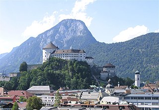
Kufstein is a town in the Austrian state of Tyrol, the administrative seat of Kufstein District. With a population of about 20,000 it is the second largest Tyrolean town after the state capital Innsbruck. The greatest landmark is Kufstein Fortress, first mentioned in the 13th century. The town was the place of origin of the Austrian noble family Kuefstein.
The Bezirk Kufstein is an administrative district (bezirk) in Tyrol, Austria. It borders Bavaria (Germany) in the north, the Kitzbühel district in the southeast, and the Schwaz district in the southwest.
State Highway 94 is a New Zealand state highway connecting the large Southland town of Gore with one of New Zealand's most popular destinations, Milford Sound. It also passes the significant townships of Lumsden and Te Anau as well going through the Homer Tunnel. The road also goes through Fiordland and crosses the Main Divide of the Southern Alps.
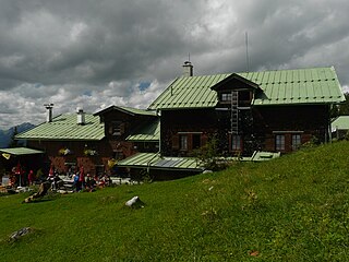
The Vorderkaiserfelden Hut is an alpine hut in the Kufstein district, Austria. It is located at 1,384 metres (4,541 ft) on the southwest slope of the Zahmer Kaiser below the Naunspitze and high above the Kaisertal valley in the Kaisergebirge mountain range. It has a good view over the Inn valley and Kufstein and across to the Mangfall Mountains and the Wilder Kaiser.
The Tauern Railway Tunnel in Austria is the longest tunnel of the Tauern Railway crossing the main chain of the Alps. Currently, it has a length of 8.371 kilometres (5.201 mi). The highest point of the tunnel, which is also the highest point in all of the railway line, is at 1,226 metres (4,022 ft) above sea level. The tunnel's north entrance is at Böckstein in the valley of Bad Gastein in the state of Salzburg, while the south entrance is near Mallnitz in Carinthia.
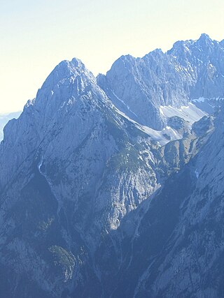
The Kaiser Mountains are a mountain range in the Northern Limestone Alps and Eastern Alps. Its main ridges – are the Zahmer Kaiser and south of it the Wilder Kaiser. The mountains are situated in the Austrian province of Tyrol between the town of Kufstein and the town of St. Johann in Tirol. The Kaiser Mountains offer some of the loveliest scenery in all the Northern Limestone Alps.
The Lower Inn Valley Railway is a two-track, electrified railway line that is one of the major lines of the Austrian railways. It was originally opened as the k.k. Nordtiroler Staatsbahn. It begins at the German border near the Austrian city of Kufstein as a continuation of the Rosenheim–Kufstein line and runs in a generally south-westerly direction through Tyrol along the Inn valley to Innsbruck. The line is part of the Line 1 of Trans-European Transport Networks (TEN-T). The line is owned and operated by Austrian Federal Railways (ÖBB).
The New Lower Inn Valley railway is a partially completed double-track high-speed main line of the Austrian railways. It connects the Brenner railway at Innsbruck and the Innsbruck bypass with the line to Kufstein, connecting with Germany, Salzburg, and eastern Austria. It forms a part of the core of the network of Austrian Federal Railways (ÖBB). The bypass is part of Line 1 of the Trans-European Transport Networks (TEN-T). The first section (Kundl–Baumkirchen), which is designed for speeds up to 220 km/h (140 mph), was opened on 26 November 2012. Since the timetable change on 9 December 2012, it relieves the existing Lower Inn Valley railway between Wörgl and Baumkirchen with trains able to operate at up to 250 km/h (160 mph). In the future, these and other construction projects are expected to reduce travel time on the Munich–Innsbruck route from 1:50 to 0:55 and on the Munich–Verona route from 5:20 to 2:20. The cost of the project amounted to €2.358 billion.
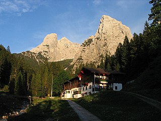
The Stripsenjoch is a small mountain pass in Austria with a height of 1,577 m (AA), which forms a bridge between the mountain ridges of the Zahmer Kaiser and the Wilder Kaiser, the two halves of the Kaisergebirge. In addition it marks the watershed between the Kaisertal in the west and the Kaiserbach valley in the east. It derives its name from the neighbouring peak of the Stripsenkopf. At the same time the Stripsenkopf is the local mountain (Hausberg) for the Stripsenjochhaus, an Alpine club hut belonging to the Austrian Alpine Club.
The Stripsenjochhaus is an Alpine club hut owned by the Kufstein branch of the Austrian Alpine Club in the Kaisergebirge mountain range in the Austrian state of Tyrol.
The Stripsenkopf is a 1,807-metre-high (5,928 ft) mountain in the Kaisergebirge range of the Northern Limestone Alps in Austria. It belongs to the Zahmer Kaiser group and its summit is covered in mountain pine.
The Hans Berger Haus is a refuge hut belonging to the Kufstein section of the Austrian Friends of Nature, located in the Kaisergebirge mountains in Tyrol. The tenants run a well-known climbing school here.
The Fritz Pflaum Hut is an Alpine club hut belonging to the Bayerland Section of the German Alpine Club, located in the Kaisergebirge mountains in the Austrian federal state of Tyrol.
The Anton Karg Haus, formerly the Neue Hinterbärenbad Hut, is an Alpine club hut belonging to the Kufstein Section of the Austrian Alpine Club in the Kaisergebirge mountains in the Austrian state of Tyrol. The hut is named after the co-founder of the Kufstein Section, Anton Karg, who was the manager of the hut from 1888 and, from 1890 to 1919, the chairman of the Kufstein Branch of the Alpine Club.
The Gaudeamus Hut is an Alpine club hut in the Kaisergebirge mountains in Tyrol. It is run by the Main-Spessart section of the German Alpine Club.
The Lärchegg is a 2,123-metre-high (6,965 ft) mountain in the Kaisergebirge range of the Northern Limestone Alps in Austria.
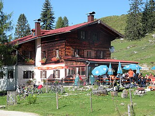
The Kaindl Hut is a privately run mountain hut at a height of 1,293 metres (4,242 ft) in the Kaiser mountains in the Austrian state of Tyrol.
The Sonneck is a 2,260-metre-high (7,410 ft) mountain in the Kaisergebirge range of the Northern Limestone Alps in Austria. On its broad peak stands a solid summit cross, the panorama is comprehensive and there are particularly good views of the Ellmauer Halt, the highest mountain in the range, the Treffauer and Lake Hinterstein.
The Kaiserbach is a river of Tyrol, Austria, in the valley Kaisertal in the Kaiser Mountains in the Tyrolean Unterland. It is a right tributary of the Inn. The Kaiserbach rises at about 1,500 m above sea level (NN) near the Stripsenjoch saddle and empties in Untere Sparchen, a quarter of Kufstein, into the Inn.
The Tischofer Cave is a cave in the Kaisertal valley in the Kaisergebirge mountains in Austria. It was a locally important gathering place and weapons cache during the Tyrolean Rebellion in the Napoleonic Wars. The roughly 40 m (130 ft) long cave, which is about 8.5 m (28 ft) high at the entrance, was occupied by cave bears and other predators as shelter during the Paleolithic as evidenced by numerous excavated skeletal remains. Bone tools of paleo-human inhabitants made of cave bear bones and skulls discovered here and dated to about 27,000 - 28,000 years ago may be viewed in the local history museum in the fortress at Kufstein. That dating makes the Tischofer Cave the oldest known uncontested site of human occupation in Tyrol.
This page is based on this Wikipedia article Text is available under the CC BY-SA 4.0 license; additional terms may apply. Images, videos and audio are available under their respective licenses.