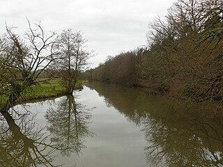
The Kaj is a river of western Afghanistan, flowing through Daykundi Province. It is a major tributary of the Helmand River.
The Kaj is a river of western Afghanistan, flowing through Daykundi Province. It is a major tributary of the Helmand River.
The river rises in the far northern province of Daykundi Province in Daykundi District in the region called Hazarajat not far from the boundary with Bamyan Province. Shortly after its birth, the Kaj follows a southbound direction. It ends with its confluence with the right bank of the Helmand river, about forty miles north of Deh Rawod.
The seasonal pattern of flow is typical of rivers in high mountains of central Afghanistan taking into account seasonal snow melt.
The average annual flow or module was calculated over a period of 6 years (from 1974 to 1979) and was more or less than 35 cubic meters per second. The curve oscillation observed daily flows in 1978 is quite similar to the average of these 6 years.
The period of high water occurs in late winter and the beginning of spring. The maximum flow is observed in late February to early May when there is snowmelt. It reaches 200 to 300 cubic meters per second on average during the first half of April. This period of high water is followed by a steadily declining rate that falls below 20 cubic meters as of early June The drop therefore slows and the rate reached its lowest average of 5 to 7 m3 per second in early autumn, i.e. in September–October. Some thunderstorms and showers are present in the dry season which account for occasional breaks in the trend. An intermediate period (with a moderate flow rate) occurs during the cold season, from early October to early March, during which the average rate rises slowly but fairly steadily, from 7 to 15 cubic meters per second.
For the year 1978 the rate fluctuated between a low of 5 and a high of approximately 160 m3. The peak was reached rapidly melting snow in April.

Iguazú Falls or Iguaçu Falls are waterfalls of the Iguazu River on the border of the Argentine province of Misiones and the Brazilian state of Paraná. Together, they make up the largest waterfall system in the world. The falls divide the river into the upper and lower Iguazu. The Iguazu River rises near the heart of the city of Curitiba. For most of its course, the river flows through Brazil; however, most of the falls are on the Argentine side. Below its confluence with the San Antonio River, the Iguazu River forms the border between Argentina and Brazil.

The Saône is a river in Eastern France. It is a right tributary of the Rhône, rising at Vioménil in the Vosges department and joining the Rhône in Lyon, at the southern end of the Presqu'île.

The Helmand River is the longest river in Afghanistan and the primary watershed for the endorheic Sistan Basin. It originates in the Sanglakh Range of the Hindu Kush mountains in the northeastern part of Maidan Wardak Province, where it is separated from the watershed of the Kabul River by the Unai Pass. The Helmand feeds into the Hamun Lake on the border between Afghanistan and Iran.

The Little Colorado River is a tributary of the Colorado River in the U.S. state of Arizona, providing the principal drainage from the Painted Desert region. Together with its major tributary, the Puerco River, it drains an area of about 26,500 square miles (69,000 km2) in eastern Arizona and western New Mexico. Although it stretches almost 340 miles (550 km), only the headwaters and the lowermost reaches flow year-round. Between St. Johns and Cameron, most of the river is a wide, braided wash, only containing water after heavy snowmelt or flash flooding.

Daykundi, also spelled as Daikundi, Daikondi, or Daykondi, is one of the thirty-four provinces of Afghanistan, located in the central part of the country. It has a population of about 516,504 and is a Hazara, and pashtun
In hydrology, discharge is the volumetric flow rate of a stream. It equals the product of average flow velocity and the cross-sectional area. It includes any suspended solids, dissolved chemicals like CaCO
3(aq), or biologic material in addition to the water itself. Terms may vary between disciplines. For example, a fluvial hydrologist studying natural river systems may define discharge as streamflow, whereas an engineer operating a reservoir system may equate it with outflow, contrasted with inflow.

The Ardèche is a 125-kilometre (78 mi) long river in south-central France, a right-bank tributary of the River Rhône. Its source is in the Massif Central, near the village of Astet. It flows into the Rhône near Pont-Saint-Esprit, north-west of Orange. The river gives its name to the French department of Ardèche.

The Orne is a river in Grand Est, north-eastern France, which is a left tributary of the Moselle and sub-tributary of the Rhine. Its source is in the hills northeast of Verdun. It flows east and joins the Moselle near Mondelange, between Metz and Thionville.

The Marghab River, anciently the Margiana, is an 850-kilometre (530 mi) long river in Central Asia. It rises in the Paropamisus Mountains in Ghor Province, flows through the Marghab District in central Afghanistan, then runs northwest towards the Bala Murghab. Reaching the oasis of Mary in the Karakum Desert of Turkmenistan, the Marghab debouches into the Karakum Canal, a diversion of water from the Amu Darya. The catchment area of the Marghab is estimated at 46,880 square kilometres (18,100 sq mi).

The Tanaro, is a 276-kilometre (171 mi) long river in northwestern Italy. The river begins in the Ligurian Alps, near the border with France, and is the most significant right-side tributary to the Po in terms of length, size of drainage basin, and discharge.

Lake Hāmūn, or the Hamoun Oasis, is a seasonal lake and wetlands in the endorheic Sīstān Basin in the Sistan region on the Afghanistan–Iran border. In Iran, it is also known as Hāmūn-e Helmand, Hāmūn-e Hīrmand, or Daryācheh-ye Sīstān.

The Gowd-i zerrah, i.e., Zerrah Depression is the lowest part of an inland drainage basin covering large parts of southern Afghanistan and Iran known as the Sistan Basin. The Sistan Basin is an endorheic basin and encompasses a complex system of rivers, shallow lakes, marshes and wetlands as its watershed, draining into the Hamun Lakes in southeastern Iran. Occasional outflows from these lakes are carried back into Afghanistan by the seasonal Shile river to the basin's terminus, the Godzareh depression in Afghanistan. The depression is flat and very shallow with fine textured sediment at its lowest portions. The lowest section of the Godzareh depression is 467 m above sea level. The depression only receives runoff water when the main tributaries are overflowing every 10 years on the average.
The Arghistan or Arghastan is a river in southern Afghanistan. It flows through Arghistan District and the provinces of Zabul and Kandahar. It is a tributary of the Dori River, a sub-tributary of the Helmand River. It flows for 280 kilometres (170 mi) and has a basin area of 20,219 square kilometres (7,807 sq mi).

The Vologne is a river of the Vosges department in France. It is a right tributary of the Moselle. Its source is in the Vosges Mountains, on the northwestern slope of the Hohneck. It flows through the lakes of Retournemer and Longemer, and passes the villages of Xonrupt-Longemer, Granges-sur-Vologne, Lépanges-sur-Vologne and Docelles, finally flowing into the Moselle in Pouxeux.

The Dahla Dam, also known as Arghandab Dam and Kasa, is located in the Shah Wali Kot District of Kandahar Province in Afghanistan, approximately 40 km (25 mi) north of the provincial capital Kandahar. It is the second largest dam in Afghanistan after the Kajaki Dam in neighboring Helmand Province. In 2019, the Afghan government planned to spend $450 million in upgrading the dam. The project includes raising the dam's walls by around 13 meters so the reservoir could hold nearly a billion cubic meters of fresh water and installing three turbines to produce 22 megawatts (MW) of electricity.
The Don is a river in Brittany, northwestern France. It is a tributary of the river Vilaine. It is 92.1 km (57.2 mi) long.
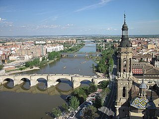
The Ebro is a river of the north and northeast of the Iberian Peninsula, in Spain. It rises in Cantabria and flows 930 kilometres (580 mi), almost entirely in an east-southeast direction. It flows into the Mediterranean Sea, forming a delta in the Province of Tarragona, in southern Catalonia. In the Iberian peninsula, it ranks second in length after the Tagus and second in discharge volume, and drainage basin, after the Douro. It is the longest river entirely within Spain; the other two mentioned flow into Portugal. It is also the second-longest river in the Mediterranean basin, after the Nile.
Changning is a county-level city in Hunan Province, China, under the administration of Hengyang prefecture-level City. Located on the south-central part of the province, the city is bordered to the north by Qidong and Hengnan Counties, to the east by Leiyang City, to the south by Guiyang County, to the west by Qiyang County. Changning City covers 2,046.6 km2 (790.2 sq mi) with registered population of 958,988 and resident population of 810,447. The city has three subdistricts, 14 towns and four townships under its jurisdiction, the government seat is Yiyang Subdistrict (宜阳街道).

The Moselotte is a river in Lorraine, in the French department of Vosges. It is a direct right tributary of the Moselle, and thus a sub-tributary of the Rhine.

The Acqua Tignese is a stream in the Haute-Corse department of the Corsica region that has its mouth north of Cap Corse, in the Ligurian Sea.
| Districts | 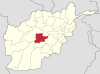 | |
|---|---|---|
| Landforms | ||
| Other | ||
| | This article related to a river in Afghanistan is a stub. You can help Wikipedia by expanding it. |