Related Research Articles

Ghana is a West African country in Africa, along the Gulf of Guinea.

Togo is a small Sub-Saharan state, comprising a long strip of land in West Africa. Togo's geographic coordinates are a latitude of 8° north and a longitude of 1°10′ east. It is bordered by three countries: Benin to the east, with 644 km (400 mi) of border; Burkina Faso to the north, with 126 km (78 mi) of border; and Ghana, with 877 km (545 mi) of border. To the south Togo has 56 km (35 mi) of coastline along the Bight of Benin of the Gulf of Guinea in the North Atlantic Ocean. Togo stretches 579 km (360 mi) north from the Gulf and is only 160 km (99 mi) wide at the broadest point. In total, Togo has an area of 56,785 km2 (21,925 sq mi), of which 54,385 km2 (20,998 sq mi) is land and 2,400 km2 (927 sq mi) is water.

The Gulf of St. Lawrence fringes the shores of the provinces of Quebec, New Brunswick, Nova Scotia, Prince Edward Island, Newfoundland and Labrador, in Canada, plus the islands Saint-Pierre and Miquelon, possessions of France, in North America.

Cape Coast is a city and the capital of the Cape Coast Metropolitan District and the Central Region of Ghana. It is located about 38.4 mi (61.8 km) from Sekondi-Takoradi and approximately 80 mi (130 km) from Accra. The city is one of the most historically significant settlements in Ghana. As of the 2010 census, Cape Coast has a population of 108,374 people. The majority of people who lived in the city are Fante.

Kumasi is a city and the capital of the Kumasi Metropolitan Assembly and the Ashanti Region of Ghana. It is the second largest city in the country, with a population of 443,981 as of the 2021 census. Kumasi is located in a rain forest region near Lake Bosomtwe and is located about 200 kilometres (120 mi) from Accra. The city experiences a tropical savanna climate, with two rainy reasons which range from minor to major. Major ethnic groups who lived in Kumasi are the Asante, Mole-Dagbon and Ewe. As of 2021, the mayor of the metropolitan is Samuel Pyne.

The Western region is located in south Ghana, spreads from the Ivory Coast in the west to the Central region in the east, includes the capital and large twin city of Sekondi-Takoradi on the coast, coastal Axim, and a hilly inland area including Elubo. It includes Ghana's southernmost location, Cape Three Points, where crude oil was discovered in commercial quantities in June 2007. The region covers an area of 13,842 km2, and had a population of 2,060,585 at the 2021 Census. It has a coastline that stretches from South Ghana's border with Ivory Coast to the it's boundary with the Central region on the east.

The Cohansey River, also called Cohansey Creek, is a 30.6-mile-long (49.2 km) river in southern New Jersey of the United States. It drains approximately 108 square miles (280 km2) of rural agricultural and forested lowlands on the north shore of Delaware Bay.

Elmina is a town and the capital of the Komenda/Edina/Eguafo/Abirem District on the south coast of Ghana in the Central Region. It is situated on a bay on the Atlantic Ocean, 12.2 km (7.6 mi) west of Cape Coast. Elmina was the first European settlement in West Africa and it has a population of 33,576 people, as of 2013. The current Municipality chief of Elmina is Solomon Ebo Appiah.

Kakum National Park, located in the coastal environs of the Central Region of Ghana, covers an area of 375 square kilometres (145 sq mi). Established in 1931 as a reserve, it was gazetted as a national park only in 1992 after an initial survey of avifauna was conducted. The area is covered with tropical forest. The uniqueness of this park lies in the fact that it was established at the initiative of the local people and not by the State Department of wildlife who are responsible for wildlife preservation in Ghana. It is one of only 3 locations in Africa with a canopy walkway, which is 350 metres (1,150 ft) long and connects seven tree tops which provides access to the forest.
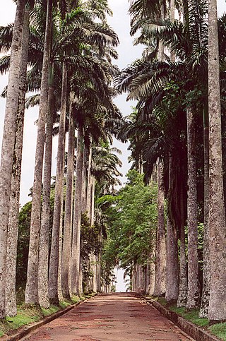
Aburi is a town in the Akuapim South Municipal District of the Eastern Region of south Ghana famous for the Aburi Botanical Gardens and the Odwira festival. Aburi has a population of 18,701 people as of 2013.

The Central Region is one of the sixteen administrative regions of Ghana. Ashanti and Eastern regions border it to the north, Western region to the west, Greater Accra region to the east, and the Gulf of Guinea to the south. The Central Region is renowned for its many elite high schools and an economy based on an abundance of industrial minerals and tourism. The Central region boasts of many tourist attractions, such as castles, forts and beaches dotted along the region's coastline.

Mfantsipim is an all-boys boarding secondary school in Cape Coast, Ghana, established by the Methodist Church in 1876 to foster intellectual, moral, and spiritual growth on the then Gold Coast. Its founding name was Wesleyan High School and the first headmaster was James Picot, a French scholar, who was only 18 years old on his appointment.
Articles related to Ghana include:

Twifo/Heman/Lower Denkyira District is a former district that was located in Central Region, Ghana. Originally created as an ordinary district assembly in 1988, which was created from the former Denkyira District Council. However on 28 June 2012, it was split off into two new districts: Twifo-Atti Morkwa District and Hemang-Lower Denkyira District. The district assembly was located in the northwest part of Central Region and had Twifo Praso as its capital town.
Prestea is a town in the Western Region, in southwest Ghana and about 50 km north of the coast of the Atlantic Ocean. It lies on the west bank of the Ankobra River, about 60 mi (100 km) northwest of Cape coast. The town is part of the Prestea-Huni Valley District. Prestea is the forty-sixth most populous in Ghana, in terms of population, with a population of 35,760 people. A railway line connects Prestea to Tarkwa and beyond to the coastal city of Sekondi-Takoradi.
The Assin-Attandanso Game Production Reserve is a protected area in the Central Region of Ghana which falls in the IUCN Category VI. The site which is adjacent to the Kakum National Park was established in 1991. The area of the site is 139.86 square kilometres (54.00 sq mi).
Abrafo is a small village located in Twifo/Heman/Lower Denkyira District of the Central Region of Ghana about 30 kilometers north of Cape Coast.
The Ministry of Tourism, Arts & Culture (MoTAC) Ghana is the government ministry responsible for the development and promotion of tourism-related activities in the country.
Tourism in Ghana is regulated by the Ministry of Tourism, Arts & Culture. This ministry is responsible for the development and promotion of tourism related activities in Ghana.
References
- ↑ "Kakum River claims three lives in Cape Coast". Modern Ghana. 7 June 2008. Retrieved 15 October 2024.
- ↑ Otchere, Gertrude Owireduwaah (2023-04-11). "Running water sweeps away boy, 12, at Cape Coast - Adomonline.com" . Retrieved 2024-10-15.
- ↑ "Kakum National Park anticipates more than 20,000 visitors in December - MyJoyOnline". www.myjoyonline.com. 2023-12-05. Retrieved 2024-10-15.
- ↑ Majumder, Rupankar (7 August 2022). "Aluminium ladders support the canopy walkway at Kakum National Park, Ghana". AL Circle. Retrieved 15 October 2024.
- ↑ "Veep inspects Kakum River dredging project". Modern Ghana. 30 July 2013. Retrieved 15 October 2024.
- ↑ "Kakum National Park (Assin Attandanso Reserve) (#)". whc.unesco.org. 15 October 2024. Retrieved 15 October 2024.