
The Northern Mariana Islands, officially the Commonwealth of the Northern Mariana Islands, is an unincorporated territory and commonwealth of the United States consisting of 14 islands in the northwestern Pacific Ocean. The CNMI includes the 14 northernmost islands in the Mariana Archipelago; the southernmost island, Guam, is a separate U.S. territory. The CNMI and Guam are the easternmost territories of the United States.

Cave-In-Rock is a village in Hardin County, Illinois, United States. Its principal feature and tourist attraction is nearby Cave-In-Rock, on the banks of the Ohio River. In 1816, the earliest known permanent white settlers arrived and started building a town near the cave. The town was originally known as Rock and Cave, Illinois, with a post office under this name. On October 24, 1849, the town was officially renamed Cave-In-Rock. Cave-In-Rock was incorporated as a village in 1901. The population was 318 at the 2010 census.

Saipan is the largest island of the Northern Mariana Islands, a commonwealth of the United States in the western Pacific Ocean. According to 2017 estimates by the United States Census Bureau and the Commonwealth's Department of Commerce, Saipan's population was 47,565.
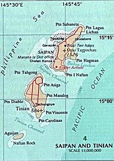
Tinian is one of the three principal islands of the Commonwealth of the Northern Mariana Islands. Together with uninhabited neighbouring Aguigan, it forms Tinian Municipality, one of the four constituent municipalities of the Northern Marianas. Tinian's largest village is San Jose.

The Yorkshire Dales is an upland area of the Pennines in the historic county of Yorkshire, England, most of it in the Yorkshire Dales National Park created in 1954.

Hagåtña is the capital village of the United States territory of Guam. From the 18th through mid-20th century, it was Guam's population center, but today it is the second smallest of the island's 19 villages in both area and population. However, it remains one of the island's major commercial districts in addition to being the seat of government.

Chamorro is an Austronesian language spoken by about 58,000 people. It is the native and spoken language of the Chamorro people, the indigenous people of the Marianas.

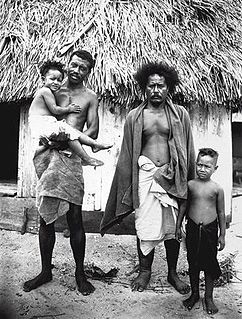
The Chamorro people are the indigenous people of the Mariana Islands, politically divided between the United States territories of Guam and the Commonwealth of the Northern Mariana Islands in Micronesia. Today, significant Chamorro populations also exist in several U.S. states including Hawaii, California, Washington, Texas, Tennessee, Oregon, and Nevada. According to the 2000 Census, approximately 65,000 people of Chamorro ancestry live in Guam and another 19,000 live in the Northern Marianas. Another 93,000 live outside the Marianas in Hawaii and the West Coast of the United States. The Chamorros are primarily Austronesian, but many also have European and Southeast Asian ancestry.

Pagan is a volcanic island in the Marianas archipelago in the northwest Pacific Ocean, under the jurisdiction of the Commonwealth of the Northern Mariana Islands. It lies midway between Alamagan to the south, and Agrihan to the north. The island has been largely uninhabited ever since most of the residents were evacuated due to volcanic eruptions in 1981.

Garapan is the largest village and the center of the tourism industry on the island of Saipan, which is a part of the United States Commonwealth of the Northern Mariana Islands (CNMI). Garapan, as a census-designated place, has an area of 1.2 km² and a population of 3,588.

The United States territory of Guam is divided into nineteen municipalities, called villages. Each village is governed by an elected mayor. Village populations range in size from under 1,000 to over 40,000. As of the 2000 census, the total population of Guam was 154,805. Each village is counted as a single county equivalent by the United States Census Bureau for statistical purposes.

The Legislature of Guam is the law-making body for the United States territory of Guam. The unicameral legislative branch consists of fifteen senators, each serving for a two-year term. All members of the legislature are elected at-large with the island under one whole district. After the enactment of the Guam Organic Act in 1950, the First Guam Legislature was elected composing of 21 elected members. Today, the current fifteen-member 36th Guam Legislature was elected in November 2020.
Songsong is the second largest village on the island of Rota, Northern Mariana Islands, United States. As of 2000, its population is 593. Songsong is located along the southern coast, in a narrow peninsula. The village's most recognizable landmark is Mt. Tinubal, more commonly known as Wedding Cake Mountain because of its resemblance to a layered wedding cake. The word songsong is a Chamorro word meaning "village, people." The village itself is subdivided into several districts:
Chalan Piao is a village on the southwestern area of Saipan. Commonwealth of the Northern Mariana Islands. It is bordered on the north by Chalan Kanoa, on the east by As Perdido village and on the south by San Antonio village. To the west is the Pacific Ocean.

Chalan Kanoa is one of the settlements on Saipan, the largest of the Northern Mariana Islands. It is located in the southwest of the island. The village contains the island's central post office, as well as the historic Our Lady of Mount Carmel Cathedral and Mount Carmel School, directed by the Spanish Mercedarian Missionaries of Berriz. Once a separate village, it is now virtually contiguous with other nearby villages on Beach Road, including Susupe and San Antonio.
Carolinians are Micronesian ethnic group who originated in Oceania, in the Caroline Islands, with a total population of around 8,500 people. They are also known as Remathau in the Yap's outer islands. The Carolinian word means "People of the Deep Sea." It is thought that their ancestors may have originally immigrated from Asia and Indonesia to Micronesia around 2,000 years ago. Their primary language is Carolinian, called Refaluwasch by native speakers, which has a total of about 5,700 speakers. The Carolinians have a matriarchal society in which respect is a very important factor in their daily lives, especially toward the matriarchs. Most Carolinians are of the Roman Catholic faith.

The Orote Peninsula is a four kilometer-long peninsula jutting from the west coast of the United States territory of Guam. A major geologic feature of the island, it forms the southern coast of Apra Harbor and the northern coast of Agat Bay. Its tip, Point Udall, is Guam's westernmost point and also the United States' westernmost point by travel, not longitude. The peninsula historically was the site of the important Chamorro village of Sumay, as well as Fort Santiago of the Spanish colonial period. In modern times, the peninsula is politically in the village of Santa Rita, but it is controlled in its entirety by Naval Base Guam.
Laolao Bay is a large bay on the southeast side of Saipan in the Northern Mariana Islands.
San Jose is the largest village on the island of Tinian, in the Northern Mariana Islands. It is located on the south coast of the island, close to the island's main harbor and three beaches: Kammer Beach, Taga Beach, and Tachogña Beach.

Latte Stone Park, officially Senator Angel Leon Guerrero Santos Latte Stone Memorial Park, is an urban park in Hagåtña, Guam. Established in the 1950s and operated by the Guam Department of Parks and Recreation, it is best known for its set of eight historical latte stones, which were transferred from their original site in Fena. The Park is located along the cliffline below the Governor's residence in Agana Heights and south of the Plaza de España. It is often visited by sightseers visiting central Hagåtña. The park also includes the entrances to two sets of caves that were constructed during the Japanese occupation (1941-1944) by forced laborers and that were listed in the National Register of Historic Places in 1991 as the Agana/Hagåtña Cliffline Fortifications.