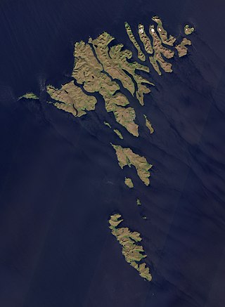
The Faroe Islands are an island group consisting of eighteen islands between the Norwegian Sea and the North Atlantic, about half-way between Iceland and Norway. Its coordinates are 62°N7°W. It is 1,393 square kilometres in area, and includes small lakes and rivers, but no major ones. There are 1,117 kilometres of coastline, and no land boundaries with any other country.
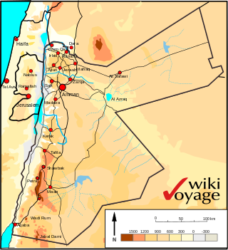
Jordan is situated geographically in West Asia, south of Syria, west of Iraq, northwest of Saudi Arabia, east of Israel and the Palestinian territory of the West Bank. The area is also referred to as the Middle or Near East. The territory of Jordan now covers about 91,880 square kilometres (35,480 sq mi).

With an area of 238,397 km2 (92,046 sq mi), Romania is the twelfth-largest country in Europe. It is a Balkan country located at the crossroads of Eastern and Southeast Europe. It's bordered on the Black Sea, the country is halfway between the equator and the North Pole and equidistant from the westernmost part of Europe—the Atlantic Coast—and the most easterly—the Ural Mountains. Romania has 3,195 kilometres (1,985 mi) of border. Republic of Moldova and Ukraine lies to the east, Bulgaria lies to the south, and Serbia and Hungary to the west. In the southeast, 245 kilometres (152 mi) of sea coastline provide an important outlet to the Black Sea and the Atlantic Ocean.

Korab is the highest peak of the eponymous mountain range and the fourth-highest mountain located entirely in the Balkan Peninsula, standing at 2,764 metres.

Chimborazo is an inactive stratovolcano situated in the Cordillera Occidental range of the Andes. Its last known eruption is believed to have occurred around 550 A.D. Despite not being the tallest mountain in the Andes or on Earth, its summit holds the distinction of being the farthest point on Earth's surface from the Earth's center, due to its location along the planet's equatorial bulge. Chimborazo's height is 6,263 m (20,548 ft), well below that of Mount Everest.

Kampong Speu is a province of Cambodia. It borders the provinces of Pursat and Kampong Chhnang to the north, Kandal to the east, Takéo to the southeast, Kampot to the south and Koh Kong to the west. Its capital is the town of Chbar Mon.
Cheaha Mountain, often called Mount Cheaha, is the highest natural point in the U.S. state of Alabama. It is located a few miles northwest of the town of Delta in Cheaha State Park, which offers a lodge, a restaurant, and other amenities. The nearest higher peak is Brushy Top in Gilmer County, Georgia, 106.72 miles away.
The Lugomir is a river in central Serbia, a 57 km-long right tributary to the Velika Morava river. It flows through many villages including Majur.

West Spanish Peak is a high and prominent mountain summit that is the higher of the two Spanish Peaks in the Rocky Mountains of North America. The prominent 13,631-foot (4,155 m) peak is located in the Spanish Peaks Wilderness of San Isabel National Forest, 9.1 miles (14.7 km) south of the Town of La Veta, Colorado, United States, on the drainage divide between Huerfano and Las Animas counties. The summit of West Spanish Peak is the highest point in Las Animas County, Colorado.

East Spanish Peak is a prominent mountain summit that is the lower of the two Spanish Peaks in the Rocky Mountains of North America. The 12,688-foot (3,867 m) peak is located in the Spanish Peaks Wilderness of San Isabel National Forest, 9.3 miles (14.9 km) southeast by south of the Town of La Veta, Colorado, United States, on the drainage divide between Huerfano and Las Animas counties. The Spanish Peaks are two large igneous stocks which form an eastern outlier of the Culebra Range, a subrange of the Sangre de Cristo Mountains. East Spanish Peak is higher than any point in the United States east of its longitude; it is also the easternmost point in the United States over 12,000 feet (3,700 m), 11,000 feet (3,400 m), and 10,000 feet (3,000 m) feet above sea level.
Amol County is in Mazandaran province, Iran. Its capital is the city of Amol.

The Acarnanian Mountains is a mountain range in the northwestern part of the Aetolia-Acarnania regional unit in western Greece. It stretches from the village Monastiraki, near Vonitsa, in the north to Astakos in the south, with a total length of nearly 40 km. The Ionian Sea lies to the west.

The topographic isolation of a summit is the minimum distance to a point of equal elevation, representing a radius of dominance in which the peak is the highest point. It can be calculated for small hills and islands as well as for major mountain peaks and can even be calculated for submarine summits.

The Battle of Čegar, also known as the Battle of Kamenica took place during the First Serbian Uprising between the Serbian Revolutionaries and Ottoman forces near the Niš Fortress on 31 May 1809. Fought on the Čegar hill situated between the villages of Donji Matejevac and Kamenica near Niš in what is today southeastern Serbia, it ended in an Ottoman victory. Commander Stevan Sinđelić famously blew up the gunpowder magazine when the Ottomans overtook his trench, killing everyone in it. Skulls of dead Serb rebels were embedded into the Skull Tower.

Banasura Hill is one of the tallest mountains in the Western Ghats of the Wayanad district, Kerala, India. The hill is named after Banasura, a mythical character of Indian legends. It is one of the highest peaks exceeding 2,000m between Nilgiris and Himalayas after Chembra Peak.

Bear Peak is a mountain summit in the Front Range of the Rocky Mountains of North America. The 8,459-foot (2,578 m) peak is located in Boulder Mountain Park, 5.2 miles (8.3 km) south-southwest of downtown Boulder in Boulder County, Colorado, United States.
North Mamm Peak is a prominent mountain summit on Grand Mesa in the Rocky Mountains of North America. The 11,129-foot (3,392 m) peak is located in White River National Forest, 11.6 miles (18.6 km) south-southwest of the Town of Rifle in Garfield County, Colorado, United States.

Oscura Mountains, originally known to the Spanish as the Sierra Oscura, are a ridge of mountains, trending north and south, east of the Jornada del Muerto and west of the Tularosa Valley. The word oscura means "dark" and refers to the dark color of the mountains due to the Pinyon-juniper vegetation at their higher elevations. The Oscuras are located in Socorro County and Lincoln County, New Mexico. Their southern end is at 33°30′30″N106°18′45″W and their northern end is at 33°49′15″N106°22′20″W near North Oscura Peak. Their highest elevation is Oscura Peak at 8,625 feet.

Cirque Peak is a 12,900-foot-elevation (3,900-meter) mountain summit located on the crest of the Sierra Nevada mountain range in California. It is situated on the common border of Tulare County with Inyo County, as well as the shared boundary of Golden Trout Wilderness and John Muir Wilderness, on land managed by Inyo National Forest. It is 14 miles (23 km) southwest of the community of Lone Pine, 7.7 miles (12.4 km) south-southeast of Mount Whitney, and 3.2 miles (5.1 km) south of Mount Langley, the nearest higher neighbor. Cirque Peak is the highest point of the Golden Trout Wilderness, and ranks as the 175th highest peak in California. Topographic relief is significant as it rises 1,800 feet above Cirque Lake in approximately one mile. The Pacific Crest Trail traverses the southwest slope of this mountain, providing an approach option. The mountain was apparently named in 1890 by Joseph Nisbet LeConte and companions who noted the remarkable cirque on the north aspect.

North Albert Peak is a 2,934-metre (9,626-foot) mountain summit located in British Columbia, Canada.

