
Kaliningrad Oblast is the westernmost federal subject of the Russian Federation, in Central and Eastern Europe. It is a semi-exclave situated on the Baltic Sea. The oblast is surrounded by two European Union and NATO members: Poland to the south and Lithuania to the north and east. The largest city and administrative centre of the province (oblast) is the city of Kaliningrad, formerly known as Königsberg. Half of the population of the oblast lives in Kaliningrad City proper. The port city of Baltiysk is Russia's only port on the Baltic Sea that remains ice-free in winter. Kaliningrad Oblast had a population of roughly 1 million in the Russian Census of 2021.

Sambia or Samland or Kaliningrad Peninsula is a peninsula in the Kaliningrad Oblast of Russia, on the southeastern shore of the Baltic Sea. The peninsula is bounded by the Curonian Lagoon to the north-east, the Vistula Lagoon in the southwest, the Pregolya River in the south, and the Deyma River in the east. As Sambia is surrounded on all sides by water, it is technically an island. Historically it formed an important part of the historic region of Prussia.

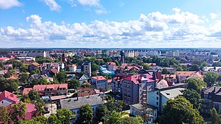
Gusev is a town and the administrative center of Gusevsky District of Kaliningrad Oblast, Russia, located at the confluence of the Pissa and Krasnaya Rivers, near the border with Poland and Lithuania, east of Chernyakhovsk. Population: 28,177 (2021 Census); 28,260 (2010 Russian census); 28,467 (2002 Census); 27,031 (1989 Soviet census).

Baltiysk is a seaport town and the administrative center of Baltiysky District in Kaliningrad Oblast, Russia, located on the northern part of the Vistula Spit, on the shore of the Strait of Baltiysk separating the Vistula Lagoon from Gdańsk Bay. Population: 33,946 (2021 Census); 32,697 (2010 Russian census); 33,252 (2002 Census); 27,070 (1989 Soviet census).
Zelenogradsk is a town and the administrative center of Zelenogradsky District in Kaliningrad Oblast, Russia, located 34 kilometers (21 mi) north of Kaliningrad, on the Sambian coastline near the Curonian Spit on the Baltic Sea. Population: 17,296 (2021 Census); 13,026 (2010 Russian census); 12,509 (2002 Census); 10,786 (1989 Soviet census).

Balga was a medieval castle of the Teutonic Knights in Kaliningrad Oblast, Russia. The castle ruins are located on the shore of the Vistula Lagoon, north of Mamonovo in the Pogranichny municipality of Bagrationovsky District, about 30 km (19 mi) southwest of Kaliningrad.
Gvardeysk, is a town and the administrative center of Gvardeysky District in Kaliningrad Oblast, Russia, located on the right bank of the Pregolya River 38 kilometers (24 mi) east of Kaliningrad. Population figures: 13,353 (2021 Census); 13,899 (2010 Russian census); 14,572 (2002 Census); 11,904 (1989 Soviet census). It is located within the historic region of Sambia.

Pravdinsk, is a town and the administrative center of Pravdinsky District in Kaliningrad Oblast, Russia. It is on the Lava River and is 30 kilometers (19 mi) east of Bagrationovsk and 53 kilometers (33 mi) southeast of Kaliningrad. Population figures: 4,323 (2010 Russian census); 4,480 (2002 Census); 4,143 (1989 Soviet census).

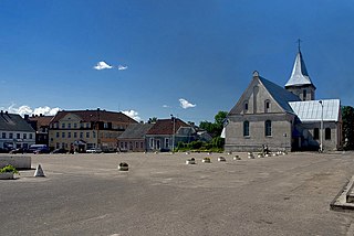
Bagrationovsk is a town and the administrative center of Bagrationovsky District in Kaliningrad Oblast, Russia, located close to the border with Poland, 37 kilometers (23 mi) south of Kaliningrad, the administrative center of the oblast. It has a population of 6,400 (2010 Russian census).

Primorsk is a town in Baltiysky District of Kaliningrad Oblast, Russia, located on the Vistula Lagoon.

Polessk is a town and the administrative center of Polessky District in Kaliningrad Oblast, Russia, located 49 kilometers (30 mi) northeast of Kaliningrad, the administrative center of the oblast, at the junction of a main road and a railroad at the Deyma River, shortly before it enters the Curonian Lagoon. Population figures: 7,581 (2010 Russian census); 7,681 (2002 Census); 6,859 (1989 Soviet census); 4,744 (1885).

Ladushkin is a town in Kaliningrad Oblast, Russia, located between Kaliningrad and the Polish border. Population figures: 3,787 (2010 Russian census); 3,796 (2002 Census); 3,108 (1989 Soviet census).

Mamonovo, is a town in Kaliningrad Oblast, Russia. Population figures: 7,761 (2010 Russian census); 7,393 (2002 Census); 7,816 (1989 Soviet census).

Pionersky ; Lithuanian: Kuršiai) is a town in Kaliningrad Oblast, Russia, located along the Baltic Sea on the Sambian Peninsula, between Zelenogradsk and Svetlogorsk. Population figures: 11,016 (2010 Russian census); 11,816 (2002 Census); 11,635 (1989 Soviet census).

Yantarny is an urban locality in Kaliningrad Oblast, Russia, located on the Sambian Peninsula, about 40 kilometers (25 mi) from Kaliningrad, the administrative center of the oblast. Population: 5,524 (2010 Russian census); 5,455 (2002 Census); 4,948 (1989 Soviet census).

Guryevsk is a town and the administrative center of Guryevsky District of Kaliningrad Oblast, Russia, located 7 kilometers (4.3 mi) northeast of Kaliningrad. Population: 19,670 (2021 Census); 12,431 (2010 Russian census); 10,913 (2002 Census); 7,934 (1989 Soviet census).

Sovetsk is a town in Kaliningrad Oblast, Russia, located on the south bank of the Neman River which forms the border with Lithuania.
Russian Prussia refers to two periods in the history of Prussia. Since 1991 Russian Prussia has been a synonym for Kaliningrad Oblast.
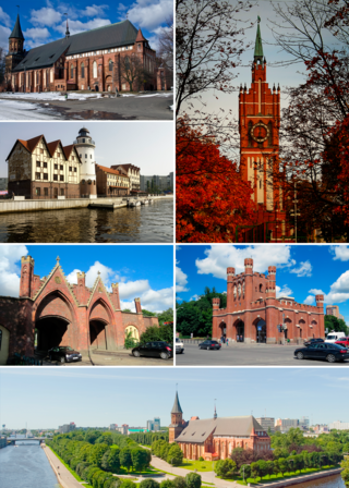
Kaliningrad, until 1946 known as Königsberg, is the largest city and administrative centre of Kaliningrad Oblast, a Russian exclave between Lithuania and Poland. The city sits about 663 kilometres (412 mi) west of the bulk of Russia. The city is situated on the Pregolya River, at the head of the Vistula Lagoon on the Baltic Sea, and is the only ice-free Russian port on the Baltic Sea. Its population in 2020 was 489,359, with up to 800,000 residents in the urban agglomeration. Kaliningrad is the second-largest city in the Northwestern Federal District, after Saint Petersburg, the third-largest city in the Baltic region, and the seventh-largest city on the Baltic Sea.

The Kaliningrad question is a political question concerning the status of Kaliningrad Oblast as an exclave of Russia, and its isolation from the rest of the Baltic region following the 2004 enlargement of the European Union.