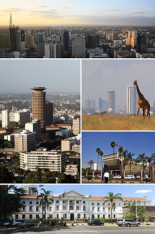
Nairobi is the capital and largest city of Kenya. The name is derived from the Maasai phrase Enkare Nairobi, which translates to "place of cool waters", a reference to the Nairobi River which flows through the city. The city proper had a population of 4,397,073 in the 2019 census, while the metropolitan area has a projected population in 2022 of 10.8 million. The city is commonly referred to as The Green City in the Sun.

Kenya, officially the Republic of Kenya, is a country in East Africa. With a population of more than 47.6 million in the 2019 census, Kenya is the 27th most populous country in the world and 7th most populous in Africa. Kenya's capital and largest city is Nairobi, while its oldest, currently second largest city, and first capital is the coastal city of Mombasa. Kisumu City is the third-largest city and also an inland port on Lake Victoria. As of 2020, Kenya is the third-largest economy in sub-Saharan Africa after Nigeria and South Africa. Kenya is bordered by South Sudan to the northwest, Ethiopia to the north, Somalia to the east, Uganda to the west, Tanzania to the south, and the Indian Ocean to the southeast. Its geography, climate and population vary widely, ranging from cold snow-capped mountaintops with vast surrounding forests, wildlife and fertile agricultural regions to temperate climates in western and rift valley counties and dry less fertile arid and semi-arid areas and absolute deserts.

Eldoret is a principal town in the Rift Valley region of Kenya and serves as the capital of Uasin Gishu County. The town was referred to by white settlers as Farm 64 and colloquially by locals as 'Sisibo'. As per the 2019 Kenya Population and Housing Census, Eldoret is the fifth most populated urban area in the country after Nairobi, Mombasa, Nakuru and Ruiru. Lying south of the Cherangani Hills, the local elevation varies from about 2,100 metres (6,900 ft) at the airport to more than 2,700 metres (8,900 ft) in nearby areas. The population was 289,380 in the 2009 Census, and it is currently the fastest growing town in Kenya with 475,716 people according to 2019 National Census.

Kisumu is the third-largest city in Kenya after the capital, Nairobi, and Mombasa. It is the second-largest city after Kampala in the Lake Victoria Basin. The city limit has a population of slightly over 600,000. The metro region, including Maseno and Ahero has over 1.2 million people.

Trans-Nzoia County is a county in the former Rift Valley Province, Kenya, located between the Nzoia River and Mount Elgon, 380 km northwest of Nairobi. At its centre is the town of Kitale which is the capital and largest town. The county borders Bungoma to the west, Uasin Gishu and Kakamega to the south, Elgeyo-Marakwet to the east, West Pokot to the north and the republic of Uganda to the Northwest. Trans Nzoia covers an area of 2495.5 square kilometres.
The Luhya comprise a number of Bantu ethnic groups native to western Kenya. They are divided into 20 culturally and linguistically related tribes.

Uasin Gishu County is one of the 47 counties of Kenya located in the former Rift Valley Province. Eldoret has the county's largest population center as well as its administrative and commercial center. “It lies between longitudes 34 degrees 50’ east and 35 degrees 37’ West and latitudes 0 degrees 03’ South and 0 degrees 55’ North. It is a highland plateau with altitudes falling gently from 2,700 meters above sea level to about 1,500 meters above sea level. The topography is higher to the east and declines gently towards the western border”.
The culture of Kenya consists of multiple traditions and trends. Kenya has no single prominent culture that identifies it. Its cultural heritage and modern expressions of culture instead consist of various cultures, shaped and practiced by the country's different communities.

The North Eastern Province is one of the former provinces in Kenya. It has a land area of 127,358.5 km2, with its capital at Garissa. Previously known as the Northern Frontier District (NFD), the North Eastern Province territory was carved out of the present-day southern Somalia during the colonial period.

After the 2013 general election, and the coming into effect of the new constitution, provinces became defunct and the country was now divided into 47 counties. Each county has its own government and therefore there is no central regional capital. Western Province became the Western region, comprising four counties: Kakamega, Bungoma, Vihiga, and Busia.
Bungoma is the county town of Bungoma County in Kenya. It was established as a trading centre in the early 20th century. It is located in Kenya's fertile Western region and at the foot of Mount Elgon, Kenya's second tallest mountain. The town and the surrounding areas boast of one of Kenya's highest average rainfall, making it one of the nation's most important food baskets.
Kisii is a municipality and urban centre in south-western Kenya and the capital of the Kisii County. Kisii Town also serves as major urban and commercial centre in the Gusii Highlands—Kisii and Nyamira counties—and the South Nyanza region and the second largest town in formerly greater Nyanza after Kisumu City. Kisii municipality sits right at the centre of the western Kenya tourist circuit that includes the Tabaka Soapstone Carvings, Maasai Mara, Ruma National Park and part of the Lake Victoria Basin.
Thika is an industrial town and a major commerce hub in Kiambu County, Kenya, lying on the A2 road 42 kilometres (26 mi), Northeast of Nairobi, near the confluence of the Thika and Chania Rivers. Although Thika town is administratively in Kiambu County, the greater Thika area comprising such residential areas such as Bendor estate, Maporomoko, Thika Greens, Thika Golden Pearl, Bahati Ridge, Thika Sports Club, among others, are within Murang'a County. Thika has a population of 279,429 which is growing rapidly, as is the entire greater Nairobi area. Its elevation is approximately 1,631 metres (5,351 ft).

Lodwar is the largest town in north-western Kenya, located west of Lake Turkana on the A1 road. Its main industries are basket weaving and tourism. The Loima Hills lie to its west. Lodwar is the capital of Turkana County. The town has a population of 82,970 in 2019.

Kwale is a small town in and the capital of Kwale County, Kenya. It is located at around 4°10′28″S39°27′37″E; 30 km southwest of Mombasa and 15 km inland. The town has an urban population of 10,063. It is next to the Shimba Hills National Reserve.
Mumias is a town in Kakamega County of Kenya. The town has an urban population of 116,358 and is the second largest town in Kakamega County. Mumias was the centre of the Mumias District. The town is linked by road to Kakamega, Busia (west), Bungoma (north), Butere, Luanda, Maseno and Kisumu (south). Two major rivers, River Nzoia and River Lusumu pass close to the town.
The Embu are a Bantu people inhabiting Embu county in Kenya. They speak the Embu language as a mother tongue. To the south of Embu are to be found their cousins, the Mbeere people. In essence Embu county encompasses the ethnic Kîembu dialect, from whom the Embu county's name derives, and the Kimbere dialect spoken by their Mbeere counterparts who inhabit the lower reaches of the county. Historically, both were just referred to as the Embu people. To the west, Embu neighbours are the closely related Kikuyu in Kirinyaga, Nyeri, Kiambu, Muranga and Nyandarua counties. The Meru people border the Embu to the East.

Bukwo District is a district in the Eastern Region of Uganda. The town of Bukwo is its main political, administrative, and commercial center and the site of the district headquarters.
Kibwezi is a town in Makueni County, Kenya.
Uriri is an electoral constituency in Kenya. It is one of eight constituencies of Migori County. There are five wards in the constituency, all electing councillors to the Migori County council. The constituency was established for the 1997 elections. Its mainly inhabited by two ethnic tribes namely Luo and the Abaluhya, who live harmoniously, with kiswahili being the lingua franca in this sub county region.
