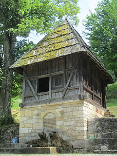
Kaludra (Rekovac)

Last updated
Kaludra (Rekovac)
Village
Serbia adm location map.svg
Red pog.svg
Kaludra (Rekovac)
Coordinates: 43°46′N21°04′E / 43.767°N 21.067°E / 43.767; 21.067
CountryFlag of Serbia.svg  Serbia
District Pomoravlje District
Municipality Rekovac
Population (2002)
  Total 327
Time zone CET (UTC+1)
  Summer (DST) CEST (UTC+2)

Kaludra is a village in the municipality of Rekovac, Serbia. According to the 2002 census, the village has a population of 327 people. [1]

Village Small clustered human settlement smaller than a town

A village is a clustered human settlement or community, larger than a hamlet but smaller than a town, with a population ranging from a few hundred to a few thousand. Though villages are often located in rural areas, the term urban village is also applied to certain urban neighborhoods. Villages are normally permanent, with fixed dwellings; however, transient villages can occur. Further, the dwellings of a village are fairly close to one another, not scattered broadly over the landscape, as a dispersed settlement.
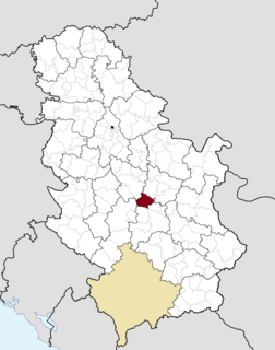
Rekovac Village and municipality in Šumadija and Western Serbia, Serbia

Rekovac is a village and municipality located in the Pomoravlje District of central Serbia. According to 2011 census, the population of the village is 1,587, while population of the municipality is 10,971. Rekovac is the center of small geographical region called Levač.

Serbia Republic in Southeastern Europe

Serbia, officially the Republic of Serbia, is a country situated at the crossroads of Central and Southeast Europe in the southern Pannonian Plain and the central Balkans. The sovereign state borders Hungary to the north, Romania to the northeast, Bulgaria to the southeast, North Macedonia to the south, Croatia and Bosnia and Herzegovina to the west, and Montenegro to the southwest. The country claims a border with Albania through the disputed territory of Kosovo. Serbia's population is about seven million. Its capital, Belgrade, ranks among the oldest and largest citiеs in southeastern Europe.

Related Research Articles

Odobești Town in Vrancea County, Romania

Odobești is a town in Vrancea County, Romania. The town administers one village, Unirea.

Extreme points of Azerbaijan Wikimedia list article

This is a list of the extreme points of Azerbaijan, the points that are farther north, south, east or west than any other location.

Tušická Nová Ves municipality of Slovakia

Tušická Nová Ves is a village and municipality in Michalovce District in the Kosice Region of eastern Slovakia.

Vedea, Giurgiu Commune in Giurgiu County, Romania

Vedea is a commune located in Giurgiu County, Romania. It is composed of a single village, Vedea. It also included Malu village until 2003, when it was split off to form Malu Commune.

Paltin Commune in Vrancea County, Romania

Paltin is a commune located in Vrancea County, Romania. It is composed of five villages: Ghebari, Paltin, Prahuda, Țepa and Vâlcani. It included seven other villages until 2005, when they were split off to form Spulber Commune.

Ususău Commune in Arad County, Romania

Ususău is a commune in Arad County, Romania, situated in the couloir zone of the Mureş River, in the northern part of the Lipovei Hills. The administrative territory of the commune is 13,543 hectares. It is composed of five villages: Bruznic (Marosborosznok), Dorgoș (Dorgos), Pătârș (Petercse), Ususău and Zăbalț (Szabálcs). Until 2005, the commune was called Dorgoș and that village was the commune centre.

Przyrownica Village in Łódź, Poland

Przyrownica is a village in the administrative district of Gmina Wodzierady, within Łask County, Łódź Voivodeship, in central Poland. It lies approximately 8 kilometres (5 mi) north-west of Wodzierady, 21 km (13 mi) north of Łask, and 28 km (17 mi) west of the regional capital Łódź.

Cholerzyn Village in Lesser Poland, Poland

Cholerzyn is a village in the administrative district of Gmina Liszki, within Kraków County, Lesser Poland Voivodeship, in southern Poland. It lies approximately 4 kilometres (2 mi) north of Liszki and 13 km (8 mi) west of the regional capital Kraków.

Gétye is a village in Zala County, Hungary.

Tržac (Aleksandrovac) Village in Župa, Serbia

Tržac is a village in the municipality of Aleksandrovac, Serbia. According to the 2002 census, the village has a population of 241 people.

Ljuša Village in Toplica District, Serbia

Ljuša is a village in the municipality of Kuršumlija, Serbia. According to the 2002 census, the village has a population of 109 people.

Arbanaška (Prokuplje) Village in Toplica District, Serbia

Arbanaška is a village in the municipality of Prokuplje, Serbia. According to the 2002 census, the village has a population of 51 people.

Lepenac (Brus) Village in Rasina District, Serbia

Lepenac is a village in the municipality of Brus, Serbia. According to the 2002 census, the village has a population of 932 people.

Tiido is a village in Kanepi Parish, Põlva County in southeastern Estonia.

Gornja Dobrinja Village in Zlatibor District, Serbia

Gornja Dobrinja is a village in the municipality of Požega, western Serbia. According to the 2002 census, the village has a population of 505 people.

Namga Village in Raška District, Serbia

Namga is a village in the municipality of Tutin, Serbia. According to the 2002 census, the village has a population of 189 people.

Boće (Raška) Village in Raška District, Serbia

Boće is a village in the municipality of Raška, Serbia. According to the 2002 census, the village has a population of 70 people.

Suvaja (Varvarin) Village in Rasina District, Serbia

Suvaja is a village in the municipality of Varvarin, Serbia. According to the 2002 census, the village has a population of 149 people.

Malan River is a river in western India in Gujarat whose origin is Mordhara hills. Its basin has a maximum length of 44 km. The total catchment area of the basin is 332 km2.

Krasnaya Rechka is the name of several rural localities in Russia:

References

  1. Popis stanovništva, domaćinstava i Stanova 2002. Knjiga 1: Nacionalna ili etnička pripadnost po naseljima. Republika Srbija, Republički zavod za statistiku Beograd 2003. ISBN   86-84433-00-9

Coordinates: 43°46′N21°04′E / 43.767°N 21.067°E / 43.767; 21.067

Geographic coordinate system Coordinate system

A geographic coordinate system is a coordinate system that enables every location on Earth to be specified by a set of numbers, letters or symbols. The coordinates are often chosen such that one of the numbers represents a vertical position and two or three of the numbers represent a horizontal position; alternatively, a geographic position may be expressed in a combined three-dimensional Cartesian vector. A common choice of coordinates is latitude, longitude and elevation. To specify a location on a plane requires a map projection.