This article needs additional citations for verification .(February 2016) |
Kaluneerkulam is a village panchayat located in the Tirunelveli district of Tamil Nadu, India.
This article needs additional citations for verification .(February 2016) |
Kaluneerkulam is a village panchayat located in the Tirunelveli district of Tamil Nadu, India.
The latitude 8.908222 and longitude 77.449022 are the geo-coordinates of the Kaluneerkulam.
The nearest railway station to Kaluneerkulam is Tenkasi Jn which is located in and around 16.0 kilometer distance.
Kaluneerkulam's nearest airport is Tuticorin Airport situated at 66.8 km distance.
Kaluneerkulam nearest schools has been listed as follows. மறவா நடுநிலை பள்ளி . Raja Middle School-0.1 km. Anna Boy S High School-3.3 km. T P S Govt Higher Secondary School-3.8 km. Rathna Middle School-5.1 km. Nadar Hindu High School-5.9 km. [1]
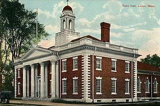
Lenox is a town in Berkshire County, Massachusetts, United States. Set in Western Massachusetts, it is part of the Pittsfield Metropolitan Statistical Area. The population was 5,025 at the 2010 census. Lenox is the site of Shakespeare & Company and Tanglewood, summer home of the Boston Symphony Orchestra. Lenox includes the villages of New Lenox and Lenoxdale, and is a tourist destination during the summer.

Utraula is a city and a municipal board in Balrampur district in the Indian state of Uttar Pradesh. It is approximately 90 kilometres from the border with Nepal and is 175 km in north east of capital city Lucknow. Utraula is situated near the West Rapti River.

Sarbhon is a village in the municipality of Bardoli in Surat district in the state of Gujarat, India. It is located about 10 km south of Bardoli, situated on the State Highway 88 between National Highway 8 and National Highway 6. Surat Airport is the nearest airport and Bardoli Railway Station is the nearest railhead.
Sakruli is a village in Punjab, India.

Rurka Kalan is a village in the Tehsil Phillaur, Jalandhar, Punjab, India.Khurd and Kalan Persian language word which means small and Big respectively when two villages have same name then it is distinguished as Kalan means Big and Khurd means Small with Village Name.
Koonimedu is a panchayat village in Tamil Nadu, India. It is part of the Marakkanam block of the Viluppuram district and is located 16 kilometres from Pondicherry and 130 km (81 mi) from Chennai. It has a population of approximately 5000 people, of whom 50% are Muslims and the remaining 50% predominantly non Muslims.Koonimedu is also known as chinna Kuwait because of their occupational route. One after another, koonimedu people travelleing Kuwait to earn. Apart from Kuwait, some other countries where Koonimedu NRIs living is Singapore, Malaysia, UAE, Oman, Qatar, France and Saudi Arabia. Koonimedu village was one of the oldest villages in Villupuram. It is said that, Muslim population spread here during period King Arcod Nawab, for his soldiers passing way to Pondicherry old French colony. The latitude 12.11574 and longitude 79.907041 are the geocoordinate of the Koonimedu. Chennai is the state capital for Koonimedu village. It is located around 116.5 km (72.4 mi) away from Koonimedu.. The other nearest state capital from Koonimedu is Pondicherry and its distance is 21.3 km The other surrounding state capitals are Pondicherry 21.3 km, Bangalore 271.3 km, Thiruvananthapuram 506.5 km (314.7 mi)
Kottaipattinam is a village panchayat located in the Pudukkottai district of Tamil Nadu state, India. The latitude 9.97908 and longitude 79.198595 are the geocoordinate of the Kottaipattinam.

Suroth is a tehsil in Hindaun Block, Karauli District, Rajasthan.
Khanduva is a village panchayat located in the district of Moradabad, Uttar Pradesh in India.

Kheri Naru, also known as Naru Ki Kheri, derived its name from the name of famous saint NARU BABA who lived there, is a village located in Karnal Tehsil of Karnal district, Haryana, India.
Beesalpur is a village in Kheragarh tehsil, Agra district, Uttar Pradesh, India, located at 16 km from main Agra city. The population was 4,106 at the 2011 Indian census.

Isoli is a village panchayat located in the Buldhana district, in the Chikhli Tehsil of Maharashtra, India. Mumbai is located 414.2 kilometer away from Isoli..
Mauzmabad is a town and a municipality in Jaipur district in the state of Rajasthan, India. The town is situated at a distance of 51.5 km from Jaipur on National Highway No. 12. Town is also one of the 16 tehsil headquarters of Jaipur District.
Chhokran is a village in Jalandhar District of Punjab State, India. The village is administrated by Sarpanch who is elected representative of village. It is located 3.8 km (2.4 mi) away from census town Apra. Chhokran is located 45 km towards East from Jalandhar, 17.5 km (10.9 mi) from Phillaur and 120 km (75 mi) from Chandigarh. The nearest train station is situated 23 km (14 mi) away in Phillaur, nearest domestic airport is at Ludhiana and the nearest international airport is 139 km (86 mi) away in Amritsar. The village has postal head office 1 km (0.62 mi) away in Moron.
Mandi is a large village in Phillaur tehsil of Jalandhar District of Punjab State, India. The village is administrated by Sarpanch who is elected representative of the village. It is 1 km away from census town and postal head office Apra. The village is 47.3 km from Jalandhar, 15 km from Phillaur and 117 km away from state capital Chandigarh.
Dahitane is a village in Barshi Taluka of Solapur district in Maharashtra, India. The village is located between Town Vairag and Tehsil Mohol. Dahitane is a village panchayat located in the Solapur district of Maharashtra state, India. The latitude 18.0079127 and longitude 75.7683995 are the geocoordinate of the Dahitane. Mumbai is the state capital for Dahitane village. It is located around 328.5 kilometer away from Dahitane. The other nearest state capital from Dahitane is Hyderabad and its distance is 295.1 km. The other surrounding state capitals are Hyderabad 295.1 km, Daman 408.8 km, Bangalore 591.6 km.
Dhameta is a village in Kangra district, Himachal Pradesh, India. Most of the villagers speak Pahari, Hindi or Punjabi, with Hindi most widely used. Panchayati Raj functions as a system of governance in Dhameta.

Kandikuppam is a panchayat in Bargur Block Krishnagiri district in the state of Tamil Nadu, India. The economy is dependent on mango cultivation. Chennai is the state capital for Kandikuppam village. It is located around 223.5 kilometer away from Kandikuppam.. The other nearest state capital from Kandikuppam is Bangalore and its distance is 93.7 km. The other surrounding state capitals are Bangalore 93.7 km., Pondicherry 178.4 km., Thiruvananthapuram 463.4 km., Kandikuppam is located along Chennai – Krishnagiri National Highway. Banks and ATM: Indian Bank with ATM, 1 India ATM. Central Government own India Post Branch post office. The surrounding nearby villages and its distance from Kandikuppam are Achamangalam 2.6 km, Kurumber Theru 1.9 km, Thandavanpallam 1.5 km, Varattanapalli 4.3 km, Karakuppam 5.4 km, Bargur 6.6 km, Thogarapalli 6.7 km, Jagadevi 6.9 km, Mallapadi 8.0 km, Oppathavadi 10.1 km, Valasagoundanoor 21.9 km, Jingalkathirampatti 27.1 km, Parandapalli 28.5 km, Kottagaram.

Avinangudi is a village panchayat located in the Cuddalore district of Tamil-Nadu state, India. The latitude of Avinangudi is 11.3851707 and its longitude is 79.1606569. Chennai is the state capital for Avinangudi village. It is located around 226.3 kilometer away from Avinangudi. The nearest state capital from Avinangudi is Pondicherry and its distance is 95.5 km. The other surrounding state capitals are Pondicherry 95.5 km., Bangalore 247.6 km., Thiruvananthapuram 392.3 km.
Pandrimalai is a village panchayat located in the Dindigul district of Tamil Nadu, India. The latitude 10.3627476 and longitude 77.99234 are the geocoordinate of the Pandrimalai. Chennai is the state capital for Pandrimalai village. It is located around 393.6 kilometer away from Pandrimalai. The other nearest state capital from Pandrimalai is Thiruvananthapuram and its distance is 226.6 km. The other surrounding state capitals are Thiruvananthapuram 226.6 km., Pondicherry 266.4 km., Bangalore 294.4 km.,
| | This Tirunelveli district location article is a stub. You can help Wikipedia by expanding it. |