
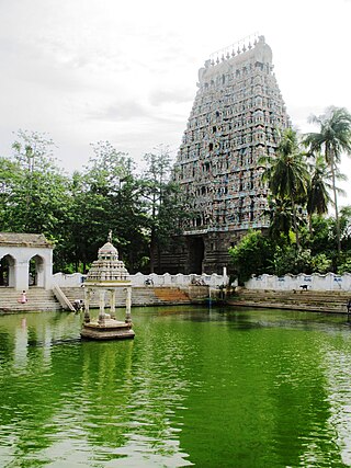
Kumbakonam, or Kudanthai, is a city municipal corporation in the Thanjavur district in the Indian state of Tamil Nadu. It is located 40 km (25 mi) from Thanjavur and 282 km (175 mi) from Chennai and is the headquarters of the Kumbakonam taluk of Thanjavur district. It is the second largest city in the district after Thanjavur. The city is bounded by two rivers, the Kaveri River to the north and Arasalar River to the south. Kumbakonam is known as a "Temple town" due to the prevalence of a number of temples here and is noted for its Mahamaham festival, which happens once in 12 years, attracting people from all over the country.

Thanjavur, also known as Thanjai, previously known as Tanjore, is a city in the Indian state of Tamil Nadu. It is the 11th biggest city in Tamil Nadu. Thanjavur is an important center of southern Indian religion, art, and architecture. Most of the Great Living Chola Temples, which are UNESCO World Heritage Monuments, are located in and around Thanjavur. The foremost among these, the Brihadeeswara Temple, built by the Chola emperor Rajaraja I, is located in the centre of the city. This temple has one of the largest bull statues in India carved out of a single granite rock. Thanjavur is also home to Tanjore painting, a painting style unique to the region. Thanjavur is the headquarters of the Thanjavur District. The city is an important agricultural centre located in the Kaveri Delta and is known as the Rice bowl of Tamil Nadu. Thanjavur is administered by a municipal corporation covering an area of 36.31 km2 (14.02 sq mi) and had a population of 222,943. Roadways are the major means of transportation, while the city also has rail connectivity. The nearest airport is Tiruchirapalli International Airport, located 59.6 km (37.0 mi) away from the city. The nearest seaport is Karaikal, which is 94 km (58 mi) away from Thanjavur. The city first rose to prominence during the reign of the Cholas when it served as the capital of the empire. After the fall of the Cholas, the city was ruled by various dynasties such as the Mutharaiyar dynasty, the Pandyas, the Vijayanagar Empire, the Madurai Nayaks, the Thanjavur Nayaks, the Thanjavur Marathas and the British Empire. It has been a part of independent India since 1947.
Mayiladuthurai is a Special grade Municipality and district headquarter of Mayiladuthurai district in Tamil Nadu, India. The town is located at a distance of 256 km (159 mi) from the state capital, Chennai.

Mannargudi is a Municipality in Thiruvarur district in the Indian state of Tamil Nadu. It is the headquarters of the Mannargudi taluk. The town is located at a distance of 28 km (17 mi) from the district headquarters Thiruvarur, 12 km from Needamangalam, 36 km from Kumbakonam, 40 km from Thanjavur, and 310 km (190 mi) from the state capital Chennai. Mannargudi is known for the Rajagopalaswamy temple, a prominent Vaishnavite shrine.

Ariyalur district is an administrative district, one of the 38 districts in the state of Tamil Nadu in India. The district headquarters is located at Ariyalur. The district encompasses an area of 1,949.31 km2.

Pudukkottai District is one of the 38 districts of Tamil Nadu state in southern India. The city of Pudukkottai is the district headquarters. It is also known colloquially as Pudhugai.

Papanasam is a panchayat town in Thanjavur district in the Indian state of Tamil Nadu. It is located 25 kilometres (16 mi) from Thanjavur and 15 kilometres (9.3 mi) from Kumbakonam. The name literally translates to "Destruction of Sins" in the Tamil language. It is the suburban region of Kumbakonam.

Pattukkottai is a major town in Thanjavur district in the Indian state of Tamil Nadu and also important town in Delta districts and Commercial town of Thanjavur, Thiruvarur and Pudukkottai district Coastal areas. The town came to prominence throughout Southern India after the construction of the fort by Vanaji Pandithar, a feudatory of the Thanjavur Maratha ruler Shahuji I in 1686–87. The recorded history of Pattukkottai is known from the 17th century and has been ruled, at different times, by the Thanjavur Marathas and the British. It is the headquarters of the Pattukkottai taluk of Thanjavur district and is one of the two municipalities in the district.
Orathanad is a town in Thanjavur district of the Indian state of Tamil Nadu. It is recognised as a Town Panchayat. It is located at a distance of 33 km from Thanjavur and 23 km from Mannargudi. The town is surrounded by vast agricultural lands.

Thanjavur district is one of the 38 districts of the state of Tamil Nadu, in southeastern India. Its headquarters is Thanjavur (Tanjore). The district is located in the delta of the Cauvery River and is mostly agrarian.

Thiruvarur district is one of the 38 districts in the Tamil Nadu state of India. As of 2011, the district had a population of 1,264,277 with a sex-ratio of 1,017 females for every 1,000 males.
Sengipatti is a village in Budalur taluk on the Tanjore–Trichy National Highway of Thanjavur district, Tamil Nadu. It is located 23 kilometers from Thanjavur, 33 kilometers from Tiruchirapalli, 46 kilometers from Pudukkottai, 65 kilometers from Ariyalur, and 66 kilometers from Kumbakonam. It is a main junction for bus routes connecting Thanjavur, Trichy, and Pudukottai districts.

Punnai Nallur is a village in the Thanjavur taluk of Thanjavur district, Tamil Nadu, India. The temple of goddess Punnainallur Mariamman is located in the outskirts of Thanjavur in the Thanjavur District.

Thanjavur is a taluk of Thanjavur district of the Indian state of Tamil Nadu.
Papanasam taluk is a taluk of Thanjavur district of the Indian state of Tamil Nadu. The headquarters of the taluk is the town of Papanasam.
Adirampattinam is a newly established Municipality in the Pattukottai taluk of the Thanjavur district in the Indian state of Tamil Nadu. It is also short known by Adirai. It is the largest coastal town in the district and fourth largest town in the Thanjavur district.
Tamil Nadu is one of the 28 states of India. Its capital and largest city is Chennai. Tamil Nadu lies in the southernmost part of the Indian Peninsula and is bordered by the States of Puducherry, Kerala, Karnataka and Andhra Pradesh. It is the tenth-largest state in India and the seventh most populous state.
Peravurani taluk is a taluk in the Thanjavur district of Tamil Nadu, India. The headquarters is the town of Peravurani.
Sathanur may refer to several places in India:
