
The West Godavari district is a coastal district in the Indian state of Andhra Pradesh with an administrative headquarters in Bhimavaram. As of the 2011 Census of India, the district has an area of 2,178 km2 (841 sq mi) and a population of 1,779,935. It is bounded by the Krishna district and Bay of Bengal to the south, East Godavari district to the east, and Eluru district, Kolleru Lake and Upputeru Drain to the northwest.

Eluru is a city and the district headquarters of Eluru district in the Indian state of Andhra Pradesh. It is one of the 14 municipal corporations in the state and the mandal headquarters of Eluru mandal in the Eluru revenue division. Situated on the banks of the Tammileru River, Eluru is strategically positioned in the southeastern part of Andhra Pradesh. It was historically known as Helapuri. As of 2011 Census of India, the city had a population of 214,414, reflecting its status as a major urban centre. The city's historical significance dates back to the second century CE, with evidence of its ancient roots found in various archaeological sites and historical records. Eluru was a prominent town under the rule of the Qutub Shahis, who governed the region in the 16th century. It came under the control of the Mughal Empire in the 17th century as the empire expanded its influence across South India. The town later became part of the Nawab of Hyderabad's dominions in the 18th century. During British India, Eluru was incorporated into the Madras Presidency and made capital for Northern Circars in the early 19th century. The British established administrative and infrastructural developments in the town, shaping its modern identity.

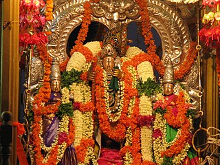
Dwaraka Tirumala is a census town in Eluru district of the Indian state of Andhra Pradesh. It is located in Dwaraka Tirumala mandal of Jangareddygudem revenue division. The Venkateswara Temple is a pilgrimage center for hindus, which is the abode of Lord Venkateswara. This is often referred by the locals as Chinna Tirupati, meaning mini Tirupati.
Narasapuram is a town in West Godavari district of the Indian state of Andhra Pradesh. It is a municipality and mandal headquarters of Narasapuram mandal in Narasapuram revenue division. The city is situated on the banks of the Vasista Godavari River. The lace industry is prevalent in the city and its surroundings.

Unguturu is a village in Eluru district of the Indian state of Andhra Pradesh. It is located in Unguturu mandal of Eluru revenue division. Vasuki Sunkavalli of this village was elected Miss India Universe in 2011. It is located 12 km from the nearest town, Tadepalligudem. As per the 2011 census of India, the village is spread over 4405 hectares with 3912 houses and a population of 14280. The number of males in the village is 7143, the number of females is 7137. The number of Scheduled Castes is 3349 and the number of Scheduled Tribes is 130.

Andhra Pradesh is a state in India. Andhra Pradesh Tourism Development Corporation (APTDC) is a state government agency which promotes tourism in Andhra Pradesh, describing the state as the Koh-i-Noor of India. Andhra Pradesh has a variety of tourist attractions including beaches, hills, caves, wildlife, forests and temples.
Eluru mandal is one of the 28 mandals in Eluru district of the Indian state of Andhra Pradesh. It is administered under Eluru revenue division and its headquarters are located at Eluru city. The mandal is bounded by Pedapadu mandal, Pedavegi mandal, Denduluru mandal, Bhimadole mandal and it also borders Krishna district.
Kamavarapukota is a mandal in Eluru district in the state of Andhra Pradesh in India.
Guntupalle is a village in Eluru District of the Indian state of Andhra Pradesh. It is located in Kamavarapukota mandal of Eluru revenue division. It is located at a distance of 42 km from district headquarters Eluru city. It is well known tourist destination famously known for Guntupalli caves. The nearest train station is Eluru railway station.
Tadikalapudi is a village in Eluru district of the Indian state of Andhra Pradesh. It is located in Kamavarapukota mandal of Eluru revenue division. It is located at a distance of 26 km from district headquarters Eluru city.
Dwaraka Tirumala mandal is one of the 28 mandals in Eluru district of the Indian state of Andhra Pradesh. It is under the administration of Eluru revenue division, and the headquarters are located at Dwaraka Tirumala. The mandal is bounded by Jangareddygudem, Koyyalagudem, Kamavarapukota, Nallajerla, Pedavegi, Unguturu, Denduluru and Bhimadole mandals.
Yerrakaluvaa is a river that forms boundary between Khammam district of Telangana and West Godavari district of Andhra Pradesh.
Chebrolu is a village in West Godavari district of the Indian state of Andhra Pradesh. It is located in Unguturu mandal of Eluru revenue division. The nearest town is Tadepalligudem.The AH45 which runs from NH16 in Kolkata to NH48 in Bangalore passes by the village with beautiful Godavari canal on the other side.
Ganapavaram mandal is one of the 20 mandals in West Godavari district of the Indian state of Andhra Pradesh. It is under the administration of Bhimavaram revenue division and the headquarters are located at Ganapavaram. Ganapavaram Mandal is bounded by Nidamarru Mandal towards west, Pentapadu Mandal towards North, Undi Mandal towards South, Unguturu Mandal towards North. Tadepalligudem, Bhimavaram, Tanuku, Eluru are the nearby Cities to Ganapavaram. It is located 55 km from Eluru and 22 km from Bhimavaram.
Velagalapalli is a village located in Chintalapudi Mandal of West Godavari District in the state of Andhra Pradesh, India.
Lingapalem Mandal is one of 28 mandals in the Eluru district of Andhra Pradesh in India. Its headquarters are located in Lingapalem. It is bordered by T.Narasapuram and Chintalapudi in the North, Khammam district tin the West, Kamavarapukota mandal in the East, and Pedavegi mandal in the South.
Nidamarru Mandal is one of 28 Mandals in the Eluru district of Andhra Pradesh, India. Its headquarters is located in Nidamarru. Its bordering states are Unguturu mandal, Bhimadole mandal, Pentapadu mandal, Ganapavaram mandal, Akividu mandal and Undi mandal.
Unguturu mandal is one of 28 mandals in the Eluru district of the Indian state of Andhra Pradesh. The headquarters are located at Unguturu. The mandal is bordered by Tadepalligudem mandal and Pentapadu mandal to the north, Nallajerla mandal to the west, Nidamarru mandal to the east, and by Dwaraka Tirumala mandal and Bhimadole mandal to the south
T. Narasapuram Mandal is one of the 28 mandals in Eluru district of the Indian state of Andhra Pradesh. The headquarters are located in T. Narasapuram town. The mandal is bordered by Jangareddygudem Mandal and Jeelugumilli to the north, Kamavarapukota Mandal to the east, Chintalapudi Mandal to the south and Khammam district to the west.

Eluru district is a district in coastal Andhra Region in the Indian state of Andhra Pradesh. With Eluru as its administrative headquarters, it was proposed on 26 January 2022 to become one of the resultant twenty six districts in the state once a final notification is issued by the government of Andhra Pradesh. It is formed from Eluru revenue division and Jangareddygudem revenue division from West Godavari district and Nuzvid revenue division from Krishna district.


