
The Black Forest is a large forested mountain range in the state of Baden-Württemberg in southwest Germany, bounded by the Rhine Valley to the west and south and close to the borders with France and Switzerland. It is the source of the Danube and Neckar rivers.

Infrared is electromagnetic radiation (EMR) in the spectral band lower than that of visible light and higher than that of microwaves. In other words, the nominal red edge of the visible spectrum is where infrared transitions to visible light; that is, IR invisible to the human eye. IR is generally understood to encompass wavelengths from around 750 nm to 1000 μm.

The Middle East is a geopolitical region encompassing the Arabian Peninsula, the Levant, Turkey, Egypt, Iran, and Iraq. The term came into widespread usage as a replacement of the term Near East beginning in the early 20th century. The term "Middle East" has led to some confusion over its changing definitions, and being seen as too Eurocentric. The region includes the vast majority of the territories included in the closely associated definition of West Asia, but without the South Caucasus, and additionally includes all of Egypt and all of Turkey.

A near-Earth object (NEO) is any small Solar System body whose orbit around the Sun can bring it near the Earth. By convention, a small natural Solar System body is a NEO if its closest approach to the Sun (perihelion) is less than 1.3 astronomical units (AU). If a NEO's orbit crosses the Earth's orbit, and the object is larger than 140 meters (460 ft) across, it is considered a potentially hazardous object (PHO). Most known PHOs and NEOs are asteroids, but about 0.35% are comets.

The Rhine is one of the major European rivers. The river begins in the Swiss canton of Graubünden in the southeastern Swiss Alps. It forms part of the Swiss-Liechtenstein, Swiss-Austrian, and Swiss-German borders. After that the Rhine defines much of the Franco-German border, after which it flows in a mostly northerly direction through the German Rhineland. Finally in Germany, the Rhine turns into a predominantly westerly direction and flows into the Netherlands where it eventually empties into the North Sea. It drains an area of 9,973 sq km and its name derives from the Celtic Rēnos. There are also two German states named after the river, North Rhine-Westphalia and Rhineland-Palatinate.

South East England is one of the nine official regions of England in the United Kingdom at the first level of ITL for statistical purposes. It consists of the counties of Buckinghamshire, East Sussex, Hampshire, the Isle of Wight, Kent, Oxfordshire, Berkshire, Surrey and West Sussex. Major towns and cities in the region include Brighton and Hove, Milton Keynes, Southampton, Portsmouth, Slough, Reading and Oxford.

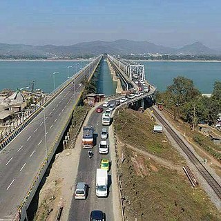
The Brahmaputra is a trans-boundary river which flows through Tibet (China), Northeastern India, and Bangladesh. It is known as Brahmaputra or Luit in Assamese,Yarlung Tsangpo in Tibetan, the Siang/Dihang River in Arunachali and Jamuna River in Bengali. It is the 9th largest river in the world by discharge, and the 15th longest.

The Near East is a transcontinental region around the East Mediterranean encompassing parts of West Asia, the Balkans, and North Africa, including the historical Fertile Crescent, the Levant, Anatolia, East Thrace and Egypt. The term was invented by modern Western geographers and was originally applied to the Ottoman Empire, but today has varying definitions within different academic circles. The term Near East was used in conjunction with the Middle East and the Far East, together known as the “3 Easts”; it was a separate term from the Middle East during earlier times and official British usage. Today, the terms Near East and Middle East are used interchangeably to refer to the same region.

Kalyan is a city on the banks of Ulhas River in Thane district of Maharashtra state in Konkan division. It is governed by Kalyan-Dombivli Municipal Corporation. Kalyan is a subdivision (Taluka) of Thane district. Kalyan and its neighbouring township of Dombivli jointly form Kalyan-Dombivli Municipal Corporation, abbreviated as KDMC. It is a founding city of the Mumbai Metropolitan Region. Kalyan is the 7th biggest city in Maharashtra and 29th in India. Kalyan also serves as a major railway station for the trains bound to Mumbai and is a large junction separating two routes, one going Karjat and other Kasara.

The conservation status of a group of organisms indicates whether the group still exists and how likely the group is to become extinct in the near future. Many factors are taken into account when assessing conservation status: not simply the number of individuals remaining, but the overall increase or decrease in the population over time, breeding success rates, and known threats. Various systems of conservation status are in use at international, multi-country, national and local levels, as well as for consumer use such as sustainable seafood advisory lists and certification. The two international systems are by the International Union for Conservation of Nature (IUCN) and The Convention on International Trade in Endangered Species of Wild Fauna and Flora (CITES).
A near-threatened species is a species which has been categorized as "Near Threatened" (NT) by the International Union for Conservation of Nature (IUCN) as that may be vulnerable to endangerment in the near future, but it does not currently qualify for the threatened status.

National Highway 16 is a major National Highway in India that runs along east coast of West Bengal, Odisha, Andhra Pradesh, and Tamil Nadu. It was previously known as National Highway 5.
A near-death experience (NDE) is a profound personal experience associated with death or impending death which researchers describe as having similar characteristics. When positive, which the great majority are, such experiences may encompass a variety of sensations including detachment from the body, feelings of levitation, total serenity, security, warmth, joy, the experience of absolute dissolution, review of major life events, the presence of a light, and seeing dead relatives. When negative, such experiences may include sensations of anguish, distress, a void, devastation, vast emptiness, seeing hellish places and "the devil".
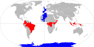
The equator is a circle of latitude that divides a spheroid, such as Earth, into the Northern and Southern hemispheres. On Earth, the Equator is an imaginary line located at 0 degrees latitude, about 40,075 km (24,901 mi) in circumference, halfway between the North and South poles. The term can also be used for any other celestial body that is roughly spherical.

The ancient Near East was the home of early civilizations within a region roughly corresponding to the modern Middle East: Mesopotamia, ancient Egypt, ancient Persia, Anatolia and the Armenian highlands, the Levant and the Arabian Peninsula. The ancient Near East is studied in the fields of ancient Near East studies, Near Eastern archaeology, and ancient history.
National Highway 27, an East - West National highway in India that starts in Porbandar and ends in Silchar, the highway passes through the states of Gujarat, Rajasthan, Madhya Pradesh, Uttar Pradesh, Bihar, West Bengal, Assam. NH-27 was laid and is maintained by Ministry of Road Transport and Highways (MoRTH). It is the second longest National Highway in India and is a part of NS-EW Corridor of NHAI.

National Highway 19 is a national highway in India. It was previously referred to as Delhi–Kolkata Road and is one of the busiest national highways in India. After renumbering of national highways, Delhi to Agra route is now national highway 44 and Agra to Kolkata route is numbered national highway 19. It constitutes a major portion of the historical Grand Trunk Road. It is also part of AH1 of Asian Highway Network, that traverses from Japan to Turkey.
National Highway 48 is a major National Highway of India that starts at Delhi and terminates at Chennai traversing through seven states of India. It has a total length of 2807 km. NH 48 passes through the states of Delhi, Haryana, Rajasthan, Gujarat, Maharashtra, Karnataka and Tamil Nadu. The stretch between Pune and Bengaluru was known as P.B. Road in olden days.

The battle of Avdiivka is an ongoing military engagement between the Russian Armed Forces and Russian-controlled Donbas militias on one side and the Ukrainian Armed Forces on the other. It is being fought over the city of Avdiivka, located in the Donbas region. Fighting started when violence erupted in the Donbas again on 21 February 2022, when Russian president Vladimir Putin recognized the Donetsk People's Republic. Days later, when Russia invaded Ukraine, Avdiivka was among the first places to be attacked.
