
Interlaken is a former district of the canton of Bern, now part of the Interlaken-Oberhasli district. Its administrative capital was Interlaken. It comprised 23 municipalities with a total area of 724 km²:

The European route E 22 is one of the longest European routes. It has a length of about 5,320 km (3,310 mi). Many of the E-roads have been extended into Asia since the year 2000; the E 22 was extended on 24 June 2002.
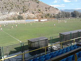
City Stadium Kičevo is a multi-purpose stadium in Kičevo, Republic of Macedonia. It is used mostly for football matches and is the home stadium of FK Napredok. The stadium holds 5,000 people.
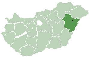
Nagyhegyes is a village in Hajdú-Bihar county, in the Northern Great Plain region of eastern Hungary.

Los Palmitos is a town and municipality located in the Sucre Department, northern Colombia.
The A2020 is a previous road in Kent but has been renumbered to A20 following the construction of the M20 motorway.
Wingham railway station was a terminus on the East Kent Light Railway. It opened in 1925 and the last passenger train ran on 30 October 1948. There was a siding to the south of the road, and carriages were usually run into the station under gravity.. Occasional freight/parcel trains ran until 1950 but the station was not officially closed until 1951.
Bryson High School or Bryson School is a public secondary school located in Bryson, Texas (USA) and classified as a 1A school by the UIL. It is part of the Bryson Independent School District located in west central Jack County. In 2015, the school was rated "Met Standard" by the Texas Education Agency.
3822 Segovia, provisional designation 1988 DP1, is a stony Flora asteroid from the inner regions of the asteroid belt, approximately 5 kilometers in diameter.
Siennica-Klawy is a village in the administrative district of Gmina Czyżew-Osada, within Wysokie Mazowieckie County, Podlaskie Voivodeship, in north-eastern Poland.
Boughrood is a village in the community of Glasbury in Powys, Wales.
Việt Ngọc is a commune (xã) and village in Tân Yên District, Bắc Giang Province, in northeastern Vietnam.
The Whangamomona River is a river of the Manawatu-Wanganui Region of New Zealand's North Island. It flows generally southeast from its sources near Whangamomona before turning east to reach the Whanganui River.
Mercury nitride describes chemical compounds that contain mercury cations and nitrido anions. Binary mercury nitrides, e.g. stoichiometrically compounds such as Hg3N2, are not well characterized and are probably unstable in the condensed phase under ordinary conditions. A nitride of mercury has been reported in the form of [Hg2N](NO3). This reddish solid adopts a network structure consisting of NHg4 tetrahedra linked by nitrate ligands.
The Estonian Sports and Olympic Museum, founded in 1963 and modernised in 2001, is the largest sports museum in the Baltic states. The museum is located on Rüütli street in Tartu, Estonia and the museum has a small outpost in Otepää that concentrates on the Winter sports. Before 2016, Estonian Sports and Olympic Museum was named Estonian Sports Museum.
Eşmekaya, Hopa is a village in the District of Hopa, Artvin Province, Turkey. As of 2010 it had a population of 363 people.
English Township is a township in Lucas County, Iowa, USA.
The Siege of Nice took place between 15 March 1705 and 4 January 1706 as part of the War of the Spanish Succession. It pitched the forces of Louis XIV of France against those of Victor Amadeus II of Savoy – the latter were led by the marquis of Caraglio.
IC 2714 is an open cluster in the constellation Carina. It was discovered by James Dunlop in 1826. It is located approximately 4,000 light years away from Earth, in the Carina–Sagittarius Arm.
Kinfauns railway station served the area of Kinfauns, Perth and Kinross, Scotland, from 1847 to 1950 on the Dundee and Perth Railway.


