
Bragg Creek is a hamlet in southern Alberta under the jurisdiction of Rocky View County in Division No. 6. It is also recognized as a designated place by Statistics Canada.

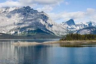
Kananaskis Country is a park system situated to the west of Calgary, Alberta, Canada in the foothills and front ranges of the Canadian Rockies. Kananaskis Country can be accessed by three highways that run into or through the area: Highway 40, a 66 km (41 mi) segment of the Bighorn Highway and also known as Kananaskis Trail; Highway 66, a 28 km (17 mi) highway originating near Bragg Creek known as Elbow Falls Trail; and Highway 68, a 42 km (26 mi) gravel highway originating from the Trans-Canada Highway known as Sibbald Creek Trail.

Exshaw is a hamlet in Alberta, Canada within Municipal District (M.D.) of Bighorn No. 8. Located approximately 90 kilometres (56 mi) west of downtown Calgary and 15 kilometres (9.3 mi) east of Canmore, Exshaw is situated within the Bow River valley north of the Bow River.
Peter Lougheed Provincial Park is a provincial park located in Alberta, Canada. The park is in Kananaskis Country about 90 kilometres (56 mi) west of Calgary, along the Kananaskis Trail.

Division No. 15 is a census division in Alberta, Canada. The majority of the division is located in Alberta's Rockies, while the southernmost portion of the division is located within southern Alberta. The division's largest urban community is the Town of Canmore.

Alberta Provincial Highway No. 40, commonly referred to as Highway 40, is a south-north highway in western Alberta, Canada. It is also named Bighorn Highway and Kananaskis Trail in Kananaskis Country. Its segmented sections extend from Coleman in the Municipality of Crowsnest Pass northward to the City of Grande Prairie and is currently divided into four sections.
Benchlands is a hamlet in Alberta within the Municipal District of Bighorn No. 8. The Ghost River is located on the hamlet's south side, while Highway 40 borders the north side.

Lac des Arcs is a hamlet in Alberta, Canada within the Municipal District (M.D.) of Bighorn No. 8. It is located on the south side of the Bow River opposite the Hamlet of Exshaw and has an elevation of 1,320 metres (4,330 ft). Highway 1 borders Lac des Arcs on the south.
Stoney 142, 143, 144 make up an Indian reserve in southwest Alberta, Canada in Division No. 15. It is home to the Bearspaw, Chiniki and Wesley first nations of the Nakoda.
Seebe is a former hamlet in Alberta, Canada, within the Municipal District of Bighorn No. 8. It is a former Calgary Power Company Ltd. employee townsite that was closed on August 31, 2004.

Acadia Valley is a hamlet in southeast Alberta within the Municipal District (M.D.) of Acadia No. 34. The M.D. of Acadia No. 34's municipal office is located in Acadia Valley.

Wildwood is a hamlet in west-central Alberta, Canada within Yellowhead County. It is located on the Yellowhead Highway, approximately 112 kilometres (70 mi) west of Edmonton and 82 kilometres (51 mi) east of Edson. The Yellowhead Highway's intersection with Cowboy Trail is 9 kilometres (5.6 mi) east of the hamlet. The Lobstick River, which flows from Chip Lake to the west, runs through the hamlet.
Ghost Lake is a summer village in Alberta, Canada. It is located between the Bow Valley Trail and the northern shore of the Ghost Lake Reservoir in the Municipal District of Bighorn No. 8, west of Cochrane.
Dead Man's Flats is a hamlet in Alberta within the Municipal District of Bighorn No. 8. Statistics Canada also recognizes it as a designated place under the name of Pigeon Mountain. It is located within Alberta's Rockies at Highway 1 exit 98, approximately 7 kilometres (4.3 mi) southeast of Canmore and 78 kilometres (48 mi) west of Calgary.
Harvie Heights is a hamlet in Alberta, Canada within the Municipal District of Bighorn No. 8. It is located within Alberta's Rockies on the Trans-Canada Highway approximately 4 kilometres (2.5 mi) northwest of Canmore and immediately east of the park gate for Banff National Park.
Kananaskis Village is an unincorporated community in Alberta's Rockies within the Kananaskis Country park system in the Kananaskis Improvement District of Alberta, Canada. It is located approximately 26 km (16 mi) south of the Trans-Canada Highway, 3 km (1.9 mi) west of Highway 40 via Mt. Allan Drive and Centennial Drive. The community is located on the west shore of the Kananaskis River at the base of Mount Kidd.
Lodgepole is a hamlet in central Alberta, Canada within Brazeau County. It is located approximately 31 kilometres (19 mi) west of Highway 22 and 131 kilometres (81 mi) southwest of Edmonton.
New Brigden is a hamlet in southern Alberta, Canada within Special Area No. 3. It is located 1 kilometre (0.62 mi) east of Highway 41, approximately 185 kilometres (115 mi) north of Medicine Hat.
Kananaskis Improvement District is an improvement district in Alberta, Canada. It is located within Alberta's Rockies, sharing much of its boundaries with Kananaskis Country.


