Clendenin is a town in Kanawha County, West Virginia along the Elk River. The population was 1,227 at the 2010 census.

Dunbar is a city in Kanawha County, West Virginia, along the Kanawha River. The population was 7,907 at the 2010 census.

Pinch is a census-designated place (CDP) in Kanawha County, West Virginia, United States. The population was 3,262 at the 2010 census.

Sissonville is a census-designated place (CDP) in Kanawha County, West Virginia, along the Pocatalico River. The population was 4,028 at the 2010 census. Sissonville is located less than 14 miles north of Charleston.

South Charleston is a city in Kanawha County, West Virginia, United States The population was 13,450 at the 2010 census. South Charleston was established in 1906, but not incorporated until 1917.

Buffalo is a town in Putnam County, West Virginia, United States, along the Kanawha River. The population was 1,236 at the 2010 census. Buffalo is a part of the Huntington-Ashland, WV-KY-OH, Metropolitan Statistical Area (MSA).

Red House is a small unincorporated community located in Putnam County in the U.S. state of West Virginia. The community is divided into two distinct areas: Red House (Proper) which follows the Kanawha River Valley along WV 62, and Red House Hill along WV 34 which is in the hills just off the Kanawha River Valley. The Red House Post Office is still in service and was founded on September 26, 1840. Some say the town was named for a red house which stood at the town site, while others believe nearby red rock formations account for the name.

The Little Kanawha River is a tributary of the Ohio River, 169 mi (269 km) long, in western West Virginia in the United States. Via the Ohio, it is part of the watershed of the Mississippi River, draining an area of 2,320 mi² (6,009 km²) on the unglaciated portion of the Allegheny Plateau. It served as an important commercial water route in the early history of West Virginia, particularly in the logging and petroleum industries.
Marshall University – South Charleston Campus is a non-residential branch campus of Marshall University located in South Charleston, West Virginia, which is primarily focused on extension graduate programs.

Kanawha State Forest is a 9,300-acre (38 km2) recreation area located near the community of Loudendale, West Virginia, which is about 7 miles (11 km) from downtown Charleston, West Virginia, United States. It is managed by the West Virginia Department of Natural Resources.

The Battle of Charleston was an engagement on September 13, 1862, near Charleston, Virginia during the American Civil War. It should not be confused with the Battle of Charleston (1861), which occurred a year earlier in Missouri.

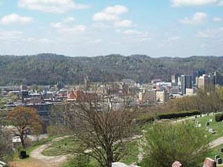
The Charleston Metropolitan Statistical Area, as defined by the United States Census Bureau, is an area consisting of three counties in West Virginia, anchored by the city of Charleston. It is the largest metropolitan area entirely within the state of West Virginia. While the Huntington Metro Area is more populous, it spans three states, and the core county of the Charleston area, Kanawha County, is more populous than the West Virginia portion of the Huntington area.

The United States District Court for the Southern District of West Virginia is a federal court in the Fourth Circuit.

Mallory Airport is a private-use airport located three miles (5 km) southwest of the central business district of South Charleston, in Kanawha County, West Virginia, United States. It is privately owned by Ben F. Mallory.
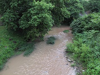
Davis Creek is a tributary of the Kanawha River, 9.4 miles (15.1 km) long, in West Virginia in the United States. Via the Kanawha and Ohio rivers, it is part of the watershed of the Mississippi River, draining an area of 47.1 square miles (122 km2) on the unglaciated portion of the Allegheny Plateau, in the Charleston metropolitan area.
Georges Creek is a stream in the U.S. state of West Virginia. It is a tributary of the Kanawha River.
Walgrove is an unincorporated community in Kanawha County, in the U.S. state of West Virginia.
Wellford is an unincorporated community in Kanawha County, in the U.S. state of West Virginia.